Save river basin - Natural Environment
Topography
The higher elevations flank the northern and northeastern regions of the basin, with considerably lower values in the Mozambique section. Some lakes are seen in center to west locations in the middle basin.
North-east Zimbabwe, the Mutanda Range forms part of the Mutare–Odzi gold belt, which stretches from Penhalonga Valley down to the Save River and this, has been mentioned to be an important gold mining area with combined historical production (Chipangura, 2019).
Geology
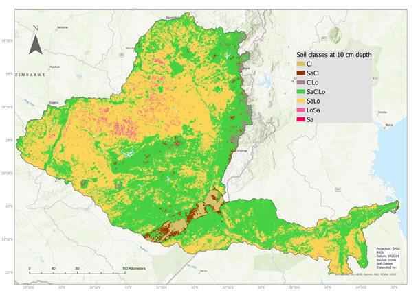
In the following figure, soil texture classes from the USDA system, acquired from the OpenLandMap Soil Texture dataset, show the basin soil classification with 250 m spatial resolution at 10 cm depth (Tomislav Hengl, 2021). The majority of the basin is classified as Sandy Loam or Sandy Clay Loam soils, with an interesting formation of Sandy Clay and Clay in the middle basin section.
References:
Chipangura, N. (2019). “We are one big happy family”: The social organisation of artisanal and small scale gold mining in Eastern Zimbabwe. The Extractive Industries and Society, 6(4), 1265–1273. https://doi.org/10.1016/j.exis.2019.08.001
Tomislav Hengl (2021). Soil texture classes (USDA system) for 6 soil depths (0, 10, 30, 60, 100 and 200 cm) at 250 m. Publicación en línea avanzada. https://doi.org/10.5281/zenodo.2525817