Save river basin - Hydrology
River Network
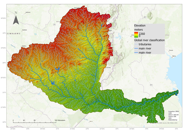
The map below shows the main river network, along with the smaller tributaries across the basin, from the Global River Classification data (Ouellet Dallaire et al., 2019). There is a wetland located in the lower deltaic plain of the Save river, which has been considered unique as it shows minimal influence of human activities in comparison with other tropical deltas with mangrove ecosystems (Massuanganhe et al., 2018).
Hydroclimatic events
(Ray et al., 2022) mention that, in relation to extreme hydro climatic events, major cyclones have made landfall in the study area over the last 15 years: Eline in 2000, Japhet in 2003 and Favio in 2007. The wetland presents seasonal floodings, associated with the river discharge and storm surges that tend to raise sea level temporarily too.
More recently, in 2019, Cyclone Idai hit eastern Zimbabwe, with particular consequences in Chimanimani and Chipinge (Verbist, 2022). Due to particular risk of droughts, floods and landslides in the Chimanimani district, disaster risk mapping has been implemented, high-resolution flood and drought monitoring and early warning systems have been deployed. While there are also some activities to mobilize the population on a preventive approach, highlighted by workshops such as “Towards a community focused flood Early Warning System for the Buzi-Pungwe and Save (BuPuSa) Transboundary River Basins”, these activities have been joint efforts from organization like the Zimbabwe Idai Recovery Project and the UNESCO offices locally (Verbist, 2022).
A drought analysis currently undertaken by the University of Cincinnati, used the Sequent Peak Algorithm methodology for the Save and Buzi river systems, focusing on drought severity and duration. Some findings from their analysis of the time series from 1980-2015 show that the most severe and longest drought on record was the 1991-1995 period, with a deficit of 90 mm and a total duration of 5 years (Ray et al., 2022a; Verbist, 2022). The same authors highlighted the importance of furthering adaptation measures that would enhance the groundwater storage capacity, by means of aquifer recharge and surface infrastructure like check dams, since drought events are expected to come sooner and more often in the future.
Water infrastructure
A project is currently doing the necessary analysis for the proposal or the construction of water infrastructure such as check dams or major dams and undertaking a knowledge based approach to the consideration of the best structures and locations, in terms of costs, flood protection potential, environmental and social impacts. The associated study on viable gray infrastructure or Nature-based solutions development, takes into account seasonal storage and local hydro meteorological conditions, along with other social aspects like job creation and operational recommendations (Ray et al., 2022).
References:
Massuanganhe, E. A., Macamo, C., Westerberg, L.-O., Bandeira, S., Mavume, A. y Ribeiro, E. (2015). Deltaic coasts under climate-related catastrophic events – Insights from the Save River delta, Mozambique. Ocean & Coastal Management, 116, 331–340. https://doi.org/10.1016/j.ocecoaman.2015.08.008
Ouellet Dallaire, C., Lehner, B., Sayre, R. y Thieme, M. (2019). A multidisciplinary framework to derive global river reach classifications at high spatial resolution. Environmental Research Letters, 14(2), 24003. https://doi.org/10.1088/1748-9326/aad8e9
Ray, P., Mandavya, G., Tracy, J., Wi, S. y Verbist, K. (2022a). Management of Climate-Related Risks to the Chimanimani Biosphere Reserve: UNESCO contract 4500449611.
Ray, P., Mandavya, G., Tracy, J., Wi, S. y Verbist, K. (2022b). Management of Climate-Related Risks to the Chimanimani Biosphere Reserve: UNESCO contract 4500449611-Final Report.
Verbist, K. (2022). Comprehensive Resilience Building in the Chimanimani and Chipinge Districts in Zimbabwe.