Paute River Basin (Ecuador)
Socioeconomic Development
For the description of the socioeconomic aspects, the three provinces that belong to the river basin are taken as reference: Azuay, Cañar, and Morona Santiago. The area of the Paute River Basin is 6,439 km², of which 57% corresponds to the province Azuay, 24% to the province Cañar and 19% to the province Morona Santiago. This Paute River Basin covers 2.5% of the total area of Ecuador and has a population density of 101 inhabitants/km².
According to the National Statistics and Census Institute of Ecuador (INEC), the population in 2007 was 654,333 (INEC, 2007).
- This population represented 4.8% of the total population of Ecuador.
- 61% of the population was urban.
- The literacy rate was 8.8% for the population over 10 years old.
- From 2001 to 2007, there was a population growth rate of 1.92%. Assuming this growth rate remains constant, the projected population in 2027 would be 964,000, meaning that the population density will have increased from 101 inhabitants/km2 to 149 inhabitants/km2.
In 2008, the tertiary sector (provision of various services) was the greatest contributor to the regional economy (contributing between 49.8% and 52.4%) with respect to the total gross production of the area. The secondary sector (industrial production) contributed between 38.2 and 41.1% while the primary sector (agricultural, livestock and forestry sector) contributed between 9.0% and 9.5%. Table 4 describes the economic activities of the economically active population.
Table 4: Socioeconomic activities in the Paute River Basin
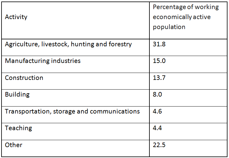
Source: Instituto Nacional de Estadística y Cencos, INEC, 2007
References and further reading:
Bendix, J., Rollenbeck, R., Göttlicher, D., and Cermak, J. (2006). Cloud occurrence and cloud properties in Ecuador. Clim. Res. 30, 133–147.
Buytaert, W., De Bièvre, B., Wyseure, G., and Deckers, J. (2004). The use of the linear reservoir concept to quantify the impact of changes in land use on the hydrology of catchments in the Andes. Hydrol. Earth Syst. Sci. 8, 108–114.
Buytaert, W., Célleri, R., De Bièvre, B., Cisneros, F., Wyseure, G., Deckers, J., Hofstede, R. (2006). Human impact on the hydrology of the Andean páramos
Earth-Science Reviews, 79 (1-2), pp. 53-72. doi: 10.1016/j.earscirev.2006.06.002.
Buytaert, W., and De Bièvre, B. (2012). Water for cities: The impact of climate change and demographic growth in the tropical Andes. Water Resources Research, 48, W08503. https://doi.org/10.1029/2011WR011755.
Campozano, L., Célleri, Ro., Trachte, K., Bendix, J., and Samaniego, E. (2016). Rainfall and Cloud Dynamics in the Andes: A Southern Ecuador Case Study. Advances in Meteorology. https://doi.org/10.1155/2016/3192765.
Célleri, R., Willems, P., Buytaert, W., and Feyen, J. (2007). Space–time rainfall variability in the Paute basin, Ecuadorian Andes. Hydrological Processes, 21, 3316–3327. https://doi.org/10.1002/hyp.6575.
Célleri, R., and Feyen, J. (2009). The hydrology of tropical Andean ecosystems: Importance, knowledge status, and perspectives. Mt. Res. Dev. 29, 350–355, doi:10.1659/mrd.00007.
Célleri, R., Buytaert, W., De Bièvre, B., Tobón, C., Crespo, P., Molina, J., and Feyen, J. (2010). Understanding the hydrology of tropical Andean ecosystems through an Andean Network of Basins. IAHS-AISH, 336, 209–212. https://doi.org/10.13140/2.1.4187.3608.
Coltorti, M., and Ollier, C.D. (2000). Geomorphic and tectonic evolution of the Ecuadorian Andes. Geomorphology 32, 1-19.
Consejo de Gestión de Aguas de la Cuenca del Paute, CG Paute (2008). Plan maestro de la Cuenca del Río Paute.
Hall, M.L., and Beate, B. (1991). El vulcanismo Plio-Quaternario en los Andes del Ecuador. El paisaje Volcanico de la Sierra Ecuatoriana. Estudios Geograficos, vol. 4, pp. 5–17
Instituto Nacional de Estadística y Cencos, INEC (2001). VI Censo de Población y V de Vivienda 2001, Resultados Definitivos, Resumen Nacional.
Instituto Nacional de Estadística y Cencos, INEC (2007). Proyecciones de la Población Ecuatoriana por Áreas y Años Calendario, según Provincias y Cantones Período 2001-2010.
Intergovernmental Panel on Climate Change, IPCC (2013). The Physical Science Basis.
Noblet, C., Lavenu, A., and Schneider, F. (1988). Etude géodynamique s'un bassin intramontagneux tertiaire sur décrochements dans les Andes du sud de l'Equateur: l'example du bassin de Cuenca. Géodynamique 3, 117–138.
Sierra, R. (1999). Propuesta preliminar de un sistema de clasificación de vegetación para el Ecuador continental. Proyecto INEFAN/GEF-BIRF y EcoCiencia. Quito, Ecuador.
Unidad de Manejo para la Cuenca del Río Paute, UMACPA (1995). Estudios Geomorfológico de la Dinámica de los Principales Procesos Erosivos y de Sedimentación de la Cuenca del Río Paute. Cuenca-Ecuador.
Vanacker, V., Molina, A., Govers, G., Poesen, J., and Deckers, J. (2007). Spatial variation of suspended sediment concentrations in a tropical Andean river system: The Paute River, southern Ecuador. Geomorphology 87, 53-67.
Vuille, M., Bradley, R.S., and Keimig, F. (2000). Climate variability in the andes of Ecuador and its relation to tropical Pacific and Atlantic sea surface temperature anomalies. J. Clim. 13, 2520–2535.