LIMARÍ (CHILE)
Natural Environment
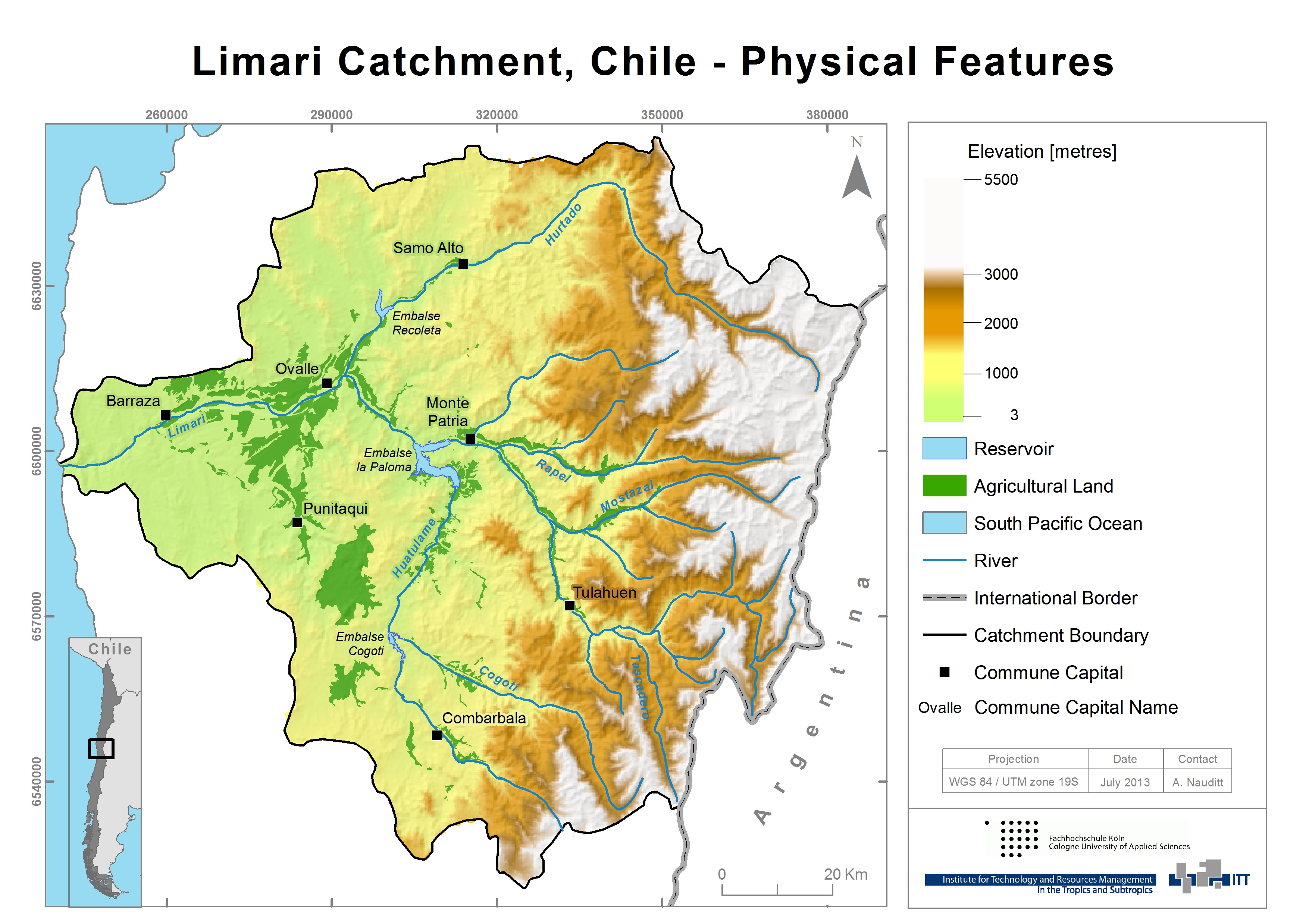
The Central Chilean semi-arid Limarí River Basin is located at the latitude of 30º 15’ to 31º 30’ S and longitude between 70º 15’ and 71º 45’ W and covers an area of 11.696 km². The basin is situated between the valleys of the Elqui basin in the North and the Choapa basin in the South and reaches from the Andes at >5500masl in the East to the coast of the Pacific Ocean in the West. The following map illustrates topography, agricultural land use and hydrology in the Limarí basin:
GEOMORPHOLOGY
Regarding the geomorphology, the basin can be characterized by the main landforms of the High Andean Mountain, the Middle Height Mountains, the Transverse Fluvial Valleys and the Coastal Stripe.
The High Mountains are corresponding to the mountain range of the Andes. Its summits overcome 3.500 meter above sea level, reaching on the Chilean-Argentine border at almost 6.000 masl. The Middle Height Mountains groups all those reliefs which height does not overcome 3.000 masl and it is separated from the Mountain range of the Andes by the fault of Vicuña. It appears like a relief dismembered and discontinuous, subject to the intense fluvial dissection. The Transverse Fluvial Valleys are characterized for presenting a complete system of terraces that correspond to the surfaces of marine sedimentation. And the coastal stripe described the area where the domain of marine terraces sedimentation starts. “Los Altos de Talinay”, a part of the coastal geomorphological structure, presents a set of platforms of marine abrasion that are correlated to the levels of sedimentation of the bays of Coquimbo and Tongoy.
GEOLOGY
The geology of the Limarí basin consists of a variety of rock formations ranging in age from Palaeozoic to Quaternary. The cordillera comprises the volcanic series of the Dona Ana Formation (Upper Oligocene-Lower Miocene). Unlike other parts of the Andes, there is no quaternary volcanism in the Coquimbo region. Nevertheless, in tectonic terms, two major phases are identified as Jurassic to lower Cretaceous (Marianas extensive type) and upper Cretaceous (Andean compressive type) (Oyarzún, 2008). The region hosts also one of the largest precious metal deposits, leading to an extensive mining exploitation. The coastal range primarily consists of Mesozoic intermediate calc‐alkaline rocks alternating with andesitic volcanic rocks. Quaternary alluvial sediments are concentrated in the river beds in the lower part of the catchments (Strauch et al., 2009; Oyarzún, 2010).
SOILS
Scarce information on soils is available for the region, especially above the cultivated areas. The entire region could be roughly divided into the coastal region and the upper Andean zone. In the coastal zone, alluvial clay rich fertile soils are found on marine terraces whereas Luvisols and Calcisols dominate in the valleys evolved from both marine and continental young sediments. Calcisols are common in arid and semiarid areas with calcareous parent materials (DGA, 2004; INIA, 2009). In the upper Andean area, where our pilot subcatchment is located, eutric and dystric Leptosols are dominating. These are very shallow unfertile soils over hard rock common in steppe landscapes in mountainous regions and are not appropriate for arable cropping (FAO, 2002; DGA, 2004). The following photograph shows the upper mountainous region at around 1000m of elevation.
Recently a study of CIREN has been released (CIREN, 2012), about the soils of the cultivated area in the region. It is an update of CIREN (1994) and also contains some geographic information.
LANDUSE
A detailed land use and vegetation classification map is missing for the region. The dominant vegetation is “Matorral”, steppe, mainly presenting bushes of sparse distribution on bare ground. Agriculture is found mainly in the valleys and flood plains of the lower areas.
The following map shows the land cover in the Limarí according to a DGA source cited by Oyarzún (2010):
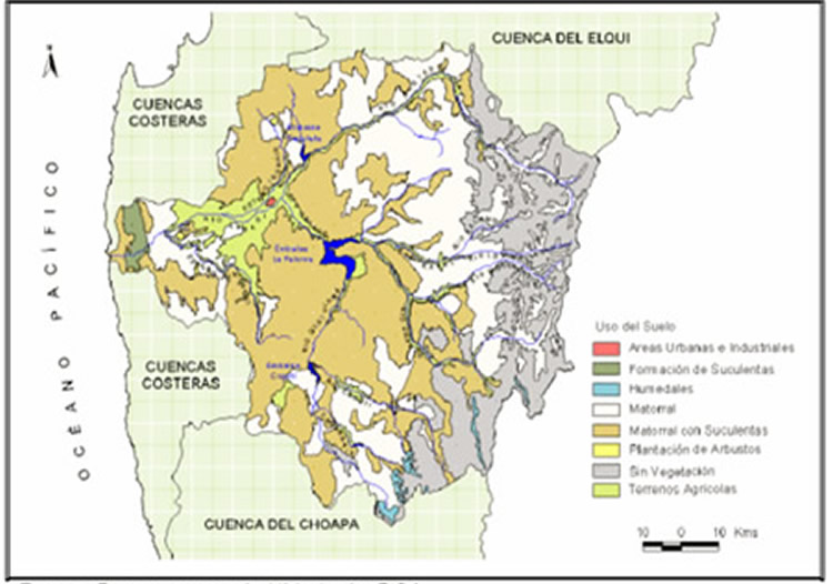
This map describes the main land cover types of the region. The brown surface represents “Matorral con Suculentas”, a sparse shrub vegetation with cacti on bare ground, which can be referred to as steppe. The light green corresponds to agricultural land, the white areas to arid mountainous “Matorral”, sparse bush vegetation, while the grey surface corresponds to rocks without vegetation.
In regard to the agricultural use, following land use characteristics can be described: the Limarí province is an important producer of high value wine grapes and table grapes. Citrus fruits, avocados and table grapes represent 34% of the cultivated area, annual crops to 24.5 % and wine to 21.5 % (Parga et al., 2005). The climatic conditions are especially favorable for the cultivation of mandarins in the Limarí Valley, which now contributes with 70% to the national production of mandarins (INIA, 2009). The total cultivated area has increased significantly since the construction of the Paloma reservoir system in 1973. Nowadays agricultural land covers an area of up to more than 62.000ha (Oyarzún, 2010). However more impressing than the total agricultural area is the change in crop types. The composition of crops has changed significantly from a large portion of annual plants as cereals to vineyards and fruit tree plantations as well as forage (Oyarzún, 2010). The extension of perennial plant types in the Limarí Valley is one of the main reasons why the permanent water demand in this area is increasing.
References and further reading:
Álvarez, P., Kretschmer, N., Oyarzún, R. (2006) Water Management for Irrigation in Chile: Causes and Consequences, paper presented at the international water fair Wasser Berlin 2006.
Ciren (1994) Estudio Agrológico de los valles de Choapa, Illapel y Limarí, Centro de Información de Recursos Naturales.
Ciren (2012) Describciones de suelos, Materiales y Simbolos, Publicación CIREN no. 129, Propiedad Intelectual N°151.231, ISBN956-7153-65-5, Esta edición complementa la cartografía digital de suelos, actualizada sobre 215 ortoimágenes satelitales año 2010-2011 en escala de salida 1:10.000 (the map in the annex shows the area of study).
DGA (2004) Diagnóstico y Clasificación de los Cursos y Cuerpos de Agua según Objetivos de Calidad. Cuenca del Río Limarí, Elaborado por CADE‐IDEPE Consultores en Ingeniería.
FAO (2002) Digital Soil Map of the World and derived soil properties, Land and Water Digital Media Series #1 rev 1. FAO, Rome.
INE (2007) Censo Agropecuario (2007), www.inecoquimbo.cl, accessed: 18.04.2012.
INIA (2009) Tierra adentro, frutales y viñas, Valle del Limarí, un aporte a la fruticultura chilena, http://www.inia.cl/link.cgi/; accessed: 12.03.2012.
Oyarzún, R., Arumí, J. L., Álvarez, P., Rivera, D. (2008) Water use in the Chilean agriculture: current situation and areas for research development, Sorensen ML (ed) Agricultural water management trends, Nova Publishers, New York, 213-236.
Oyarzún, R. (2010) Estudio de caso: Cuenca del Limarí, Región de Coquimbo, Chile, Compilación Resumida de Antecedentes, Centro de Estudios Avanzados en Zonas Aridas- Universidad de la Serena (CEAZA-ULS).
Parga, F., León, A., Vargas, X., Fuster, Y. (2006) El índice de pobreza hídrica aplicado a la cuenca del río Limarí en Chile semiárido, Eval. Usos del Agua en Tierras Secas de Iberoamérica, 12: 93-109.
Strauch, G., Oyarzún, R., Reinstorf, F., Oyarzún, J., Schirmer, M., Knöller, K. (2009) Interaction of water components in the semi-arid Huasco and Limarí river basins, North Central Chile, Advances in Geosciences, 22, 51–57.