Save river basin
Authors: Silvia Krautzik & Jorge Masis
Main description
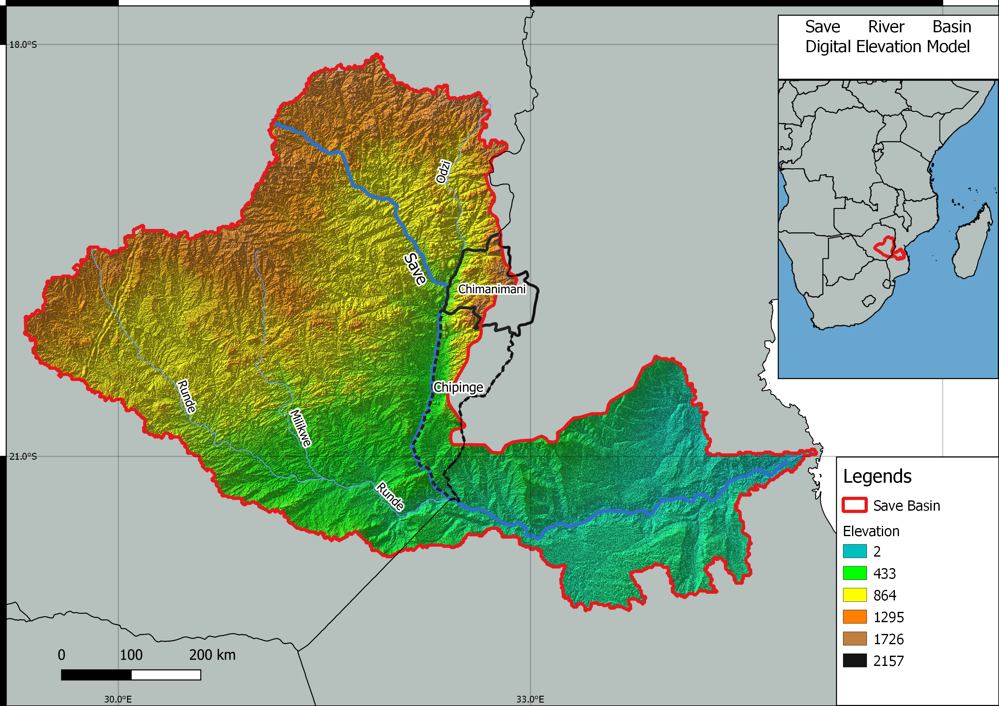
The Save basin is an African transboundary catchment, the largest northern section of its total approximately 102 000 km2 extension is located in Zimbabwe, but the drainage area includes part of southern Mozambique as well (see map below). Its main water body is the Save river, which begins flowing from about 80 km south of Harare in Zimbabwe and continues southeast from the Zimbabwean highlands. It is joined by the Odzi river and the Runde river on its path towards lower elevations and then through the Mozambique Channel, to finally flow into the Indian Ocean (Jonnalagadda y Mhere, 2001; Meck et al., 2009).
There are seven sub catchment areas in the Save catchment area, these are Odzi, Upper Save, Lower Save, Macheke, Pungwe, Devure and Budzi (Kujinga, 2002).

Figure 1: Topographic Overview of the Save River Basin (Zimbabwe/Mozambique) (Map by Juan Miguel Viquez & Daniel Knopp).
As mentioned previously, the Odzi River is one of the main tributaries in Zimbabwe's Eastern Highlands. It is of great significance as it carries waters from other mountain affluent.
In general, the basin economic activities revolve around various interests, such as communal areas with different levels of agricultural intensity and crops ranging from maize, sorghum, pine trees and even tobacco, while there are also areas dedicated primarily to forestry development or cattle and goat management (Nyoni et al., 2013). Another sector is dedicated to artisanal small-scale mining for gold (Chipangura, 2019; Meck et al., 2009).
Authors have highlighted pressures on water management in the basin concerning the extension of the cultivated land on the riverbank in many sections and land use changes due to cattle activities, leading to related problems like erosion and river siltation (Nyoni et al., 2013). Others studied possible sources of pollution coming from abandoned artisanal mining sites in the upper basin near Dorowa and necessary further analysis of sediment samples and related protection initiatives ("M. Meck et al., 2001).
Research
The Chimanimani District and Odzi subcatchment are pilot areas within the Open Science to Support Water Security in Southern Africa (OWASA) research project
Contact
Alexandra Nauditt: This email address is being protected from spambots. You need JavaScript enabled to view it.
References
Chingombe, W.; Musarandega, H. (2021): Understanding the Logic of Climate Change Adaptation: Unpacking Barriers to Climate Change Adaptation by Smallholder Farmers in Chimanimani District, Zimbabwe. In: Sustainability, 13(7):3773. https://doi.org/10.3390/su13073773
Chipangura, N. (2019). “We are one big happy family”: The social organisation of artisanal and small scale gold mining in Eastern Zimbabwe. The Extractive Industries and Society, 6(4), 1265–1273. https://doi.org/10.1016/j.exis.2019.08.001
Jonnalagadda, S.B. y Mhere, G. (2001). Water quality of the odzi river in the eastern highlands of zimbabwe. Water Research, 35(10), 2371–2376. https://doi.org/10.1016/S0043-1354(00)00533-9
Kujinga, K. (2002). Decentralizing water management: an analysis of stakeholder participation in the management of water in Odzi subcatchment area, Save Catchment. Physics and Chemistry of the Earth, Parts A/B/C, 27(11-22), 897–905. https://doi.org/10.1016/S1474-7065(02)00092-X
Meck, M., Atlhopheng, J. y Masamba, W.R.L. (2009). Current impact of mining alkaline rocks on Save River water quality in Zimbabwe. Journal of African Earth Sciences, 55(1-2), 58–62. https://doi.org/10.1016/j.jafrearsci.2008.12.006
Nyoni, K., Kaseke, E. y Shoko, M. (2013). Assessing the Presence or Absence of Climate Change Signatures in the Odzi Sub-Catchment of Zimbabwe. American Journal of Climate Change, 02(04), 225–236. https://doi.org/10.4236/ajcc.2013.24023

