MATA ATLÂNTICA DO RIO: MACACÚ (BRAZIL)
Climate
According to the Köppen classification, the GMRB belongs to the Aw (tropical wet and dry) group (Pinheiro et al., 2012). Furthermore, climate within the GMRB is strongly influenced by orography (ranging from sea level to 2,250 m.a.s.l.) and by Atlantic tropical air masses. The most important climatic system influencing precipitation patterns and temperatures in the region is the South Atlantic Convergence Zone (SACZ). SACZ is a band of convective activity with high rainfall rates existent throughout the year but stronger during the austral summer (Barreiro et al., 2002). The coastal area in the southwest of the watershed shows higher temperatures and lower precipitation rates compared to the mountain range in the northeast. For instance, Niterói (14 m.a.s.l.), representing the coastal weathering, shows an annual average temperature of 23.0°C while Nova Friburgo (856 m.a.s.l.) and Teresópolis (874 m.a.s.l.), located in the mountainous region, have an annual mean temperature of 18.0°C and 17.5°C, respectively (UFF/FEC, 2010). The maximum temperatures are reached in February (26.5°C in Niterói, 21.3°C in Teresópolis) while the lowest temperatures are experienced in July (19.6°C in Niterói, 13.7°C in Teresópolis).

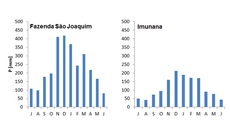
Moreover, according to the available precipitation data the mean annual precipitation within the watershed varies between 1,200mm and 2,800mm (ANA, 2012). The distribution over the year shows a relevant inter-annual variability with a maximum in the summer months from November until March and a minimum in the winter season from June until August. The orographic precipitation pattern can be observed in the next figure where the precipitation stations Fazenda São Joaquim (275 m.a.s.l.) and Imunana (10 m.a.s.l.) present annual values of 2,195 mm and 1,350 mm, respectively, for the period 1996-2010.
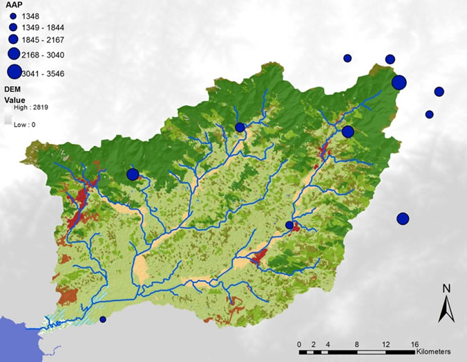
Moreover, the next figure shows the geographical distribution of available precipitations stations. Here, the orographic influence can be better observed since precipitation increases with altitude. However, the Serra dos Orgãos acts as a barrier, since the stations located after the mountain range present lower precipitation rates.
References and further reading:
Almeida, F. F. de M., Carneiro, C. dal R. (1998) Origem e Evoluçáo da Serra do Mar, Revista Brasileira de Geociências, 28(2), 135–150, http://sbgeo.org.br/pub_sbg/rbg/vol28_down/2802/2802135.pdf.
Barreiro, M., Chang, P., Saravanan, R. (2002) Variability of the South Atlantic Convergence Zone Simulated by an Atmospheric General Circulation Model, Journal of Climate, 15(7), 745–763, http://journals.ametsoc.org/doi/full/10.1175/1520-0442(2002)015<0745:VOTSAC>2.0.CO;2, accessed: 20.12.2013.
Benavides, Z. et al. (2009) Consumo e Abasticemento de Água nas Bacias Hidrográficas dos Rios Guapi-Macacu e Caceribu - RJ.
Ecologus-Agrar (2003) Plano Diretor de Recursos Hídricos da Região Hidrográfica da Baía de Guanabara, p. 3087.
Fernandes, N. F. et al. (2010) Rio de Janeiro: A Metropolis Between Granite-Gneiss Massifs, P. Migón, ed. Geomorphological Landscapes of the Worl, Springer, p. 387, http://books.google.com/books?id=-TI55urJYyEC&pgis=1, accessed: 21.12.2013.
Ferrari, A. L. (2001) Evolução Tectônica do Graben da Guanabara, Biblioteca Digital de Teses e Dissertações da USP, http://www.teses.usp.br/teses/disponiveis/44/44136/tde-29082013-152530/, accessed: 25.09.2013.
Fidalgo, E. C. et al. (2008) Uso e Cobertura da Terra na Bacia Hidrográfica do Rio Guapi-Macacu, Rio de Janeiro - Brazil.
Finotti, R. et al. (2012) Variations in structure, floristic composition and successional characteristics of forest fragments of the Guapiaçu river basin (Guapimirim/Cachoeiras de Macacu, RJ, Brazil). Acta Botanica Brasilica, 26(2), 464–475, http://www.scielo.br/scielo.php?script=sci_arttext&pid=S0102-33062012000200022&lng=en&nrm=iso&tlng=pt, accessed: 23.12.2013.
IUSS Working Group WRB (2006) World reference base for soil resources 2006, Rome.
Lumbreras, J. F. (2008) Relacoes solo-Paisagem no noroeste do estado do Rio de Janeiro: Subsídios ao Planejamento de uso sustentável em áreas de relevo acidentado do bioma Mata Atlântica, Universidade Federal de Rio de Janeiro.
Naegeli, F. E. (2010) Evaluation of Forest Fragmentation and Land Use Change Patterns using Remote Sensing Techniques and Field Methods.
Penedo, S. et al. (2011) Implementation of a Hydro-climatic Monitoring Network in the Guapi-Macacu River Basin in Rio de Janeiro Brazil, XIVth IWRA World Water Congress, Porto de Galinhas, Brazil, p. 12, http://dinario.fh-koeln.de/pdf/Implementation of a Hydro-climatic Monitoring Network in the Guapi-Macacu River Basin in Rio de Janeiro Brazil.pdf.
Pinheiro, H. S. K. et al. (2012) Modelos de elevação para obtenção de atributos topográficos utilizados em mapeamento digital de solos, Pesquisa Agropecuária Brasileira (Online), 47, p.10, http://geostat-course.org/node/1033, accessed: 23.09.2013.
Riccomini, C., Sant’Anna, L. G., Ferrari, A. L. (2004) Evolução geológica do Rift Continental do sudeste do Brasil, V. Mantesso-Neto et al., eds. Geologia do Continente Sul-Americano: Evoluçao da obra de Fernando Flávio Marques de Almeida, Beca, 383–405.
Scheffer, F. et al. (2009) Lehrbuch der Bodenkunde (Sav Geowissenschaften) (German Edition), Spektrum Akademischer Verlag, http://www.amazon.com/Lehrbuch-Bodenkunde-Geowissenschaften-German-Edition/dp/3827413249, accessed: 30.09.2013.
UFF/FEC (2010) Planejamento Estratégico da Região Hidrográfica dos Rios Guapi-Macacu e Caceribu-Macacu, Niterói, Brazil.
Wesenberg, J., Seele, C. (2009) Floristic-structural composition and diversity of tree and woody understorey vegetation in the montane Atlantic Forest of the Serra dos Órgaos National Park, Teresopolis, RJ, Brazil, H. Gaese et al., eds. Biodiversity and land use systems in the fragmented Mata Atlântica of Rio de Janeiro, Göttingen, p. 46, http://dinario.fh-koeln.de/pdf/Chapter 14_Wesenberg & Seele_259-280.pdf.