Dhaka River Basin (Bangladesh)
Natural Environment
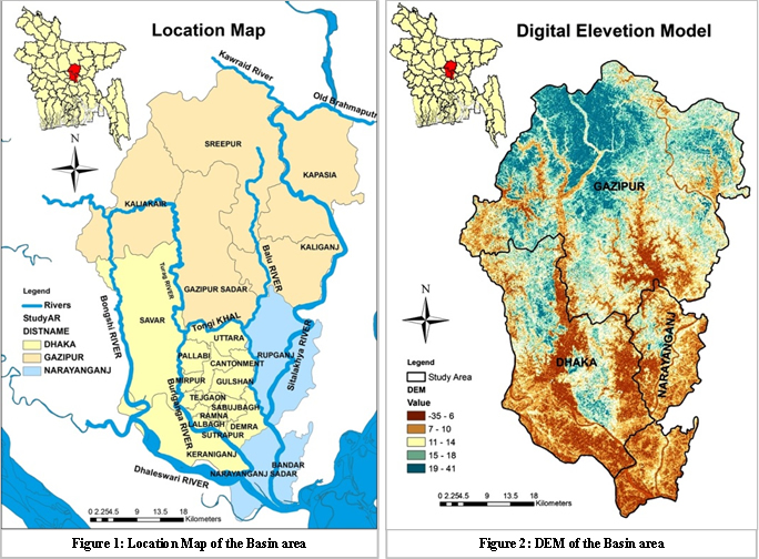
Bangladesh is a densely populated south Asian country of around 150 million inhabitants (976 per Sq Km) and consists largely of a low, flat topographical area. Constitution of the land is 80% of major rivers floodplains of the Brahmaputra, Ganges and Meghna rivers. The country has 60% land lower than 6 m above sea level. Flood events occur frequently during the wet season, which are able to inundate up to 65% of the country, while droughts are a general cause of water scarcity during the dry season. Only 7% of the country's water surface flow has a source within the country borders. The other 93% comes from Transboundary Rivers shared with India, Myanmar, Nepal, Butan and China. Dhaka river basin consists of Balu, Bongshi, Buriganga, Dhaleswari, Sitalakhya, Tongi Khal and Turag rivers. The basin area covers three districts as Dahaka, Gazipur and Narayanganj. The central region of the basin is Dhaka City Corporation and its surroundings, Savar and Keraniganj with area of 1463.60 sq. km and the population is around 15 million. The annual average temperature and rainfall is maximum 34.5°C, minimum 11.5°C and rainfall 1931 mm. The main rivers of the region is Padma, Kaliganga, Dhaleshwari, Ichamati, Shitalakshya, Buriganga; small rivers are Bangshi, Turag, Balu, Elamjani, Alam, Bherujkha, Ramkrishnadi, Elisamari, Tulsikhali.
Dhaka is the capital of Bangladesh is one of the largest growing mega megacities in the world with a growth rate of 3.2% and an estimated 300,000 to 400,000 new migrants, mostly poor, arriving to the city every year. The urbanization rate of the basin area is very high and the basin area has over 90% urban area holds 38% of its total urban population. The upper region of the basin is Gazipur district with the area of 1806.36 Sq. Km and the population is 34,03,912. The district covers five Upazilla named Gazipur Sadar, Sreepur, kapashia, Kaliakoir and kaliganj. Annual Average Temperature of the area is maximum 36°C and minimum 12.7°C; annual rainfall 2376 mm. The upper region covers main rivers as Old Brahamaputra, Shitalakshya, Turag, Bangshi, Balu and Banar. The lower part of the basin is Narayanganj district considering three Upazila as Rupganj, Narayanganj Sadar and Bandara with the area of 684.37 sq. km. and the population is around 29,48,271. The annual average temperature is maximum 35.5°C and minimum 12.7°C; annual rainfall is 2376 mm. Physically the zila is characterised by alluvial formations caused by several rivers such as, Shitalakshya, Meghna, Old Brahmaputra, Buriganga, Balu and Dhaleshwari.
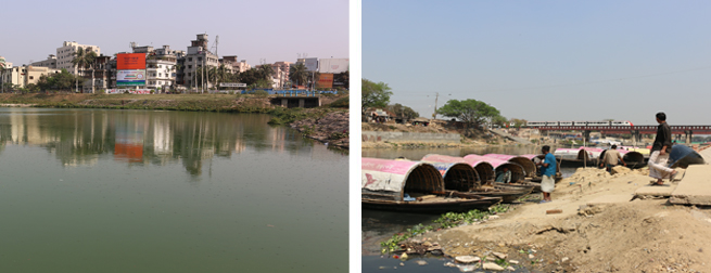
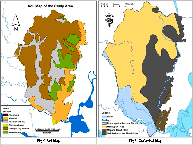
The basin is completely dependent on the ground water resources while all other sources of fresh water in the basin are almost dead or unusable. Climate change increases variability in precipitation, soil moisture and surface water in developing countries like Bangladesh. Recent days Bangladesh has prime concern to sustainably manage its ground water as it is tend to become scarce. In Dhaka river basin area, surface water withdrawal from adjacent rivers is not a proved feasible option because of high levels of industrial and domestic pollution from unregulated waste disposal.
Physiography
Dhaka basin is located in the center of Bangladesh beside the River Buriganga at the coordinate lies between 23Deg 53Min and 24Deg 06Min north latitudes and between 90º01' and 90º37' east longitudes in the central part. The upper part is lies between 23deg 53Min 0 Sec and 24 Deg 21Min 0 Sec north latitudes and between 90 Deg 09Min 0Sec and 92Deg 39Min 0Sec east longitude and the lower part lies between 23Deg 33 Min and 23Deg 57Min north latitudes and between 90Deg 26min and 90Deg 45Min east longitudes. The Metropolitan area covers 250 sq. Km, and the Dhaka river basin area covers around 3500 sq. Km. The Basin area covers Upazila named Sripur, Kapasia, Gazipur, Kaliakoir, Kaliganj, Savar, Rupganj, Keraniganj, Narayanganj and Bandar. Dhaka river basin is home to around 15 million people and may reach 22 million by the year 2025. The surface elevation of the city area ranges from 1.5 to 15 m above the mean sea level (+/− 1 m to mean sea-level). The river basin area is linked with the Ganges-Brahmaputra river system (locally known as Padma-Jamuna-Meghna river system) by the interconnecting streams and retention basins. Dhaka basin is surrounded by the Tongi Canal to the north, the Turag-Buriganga River system to the west, the Balu River to the east, and the Sitalakkhya River to the south.
Land use
In the Basin area land cover has been changed over time and one of the recent studies shows the change from 1989 to 2009 in a ten years interval. The study has indicated three possible change detections over time in between 1989 and 1999, 1999-2009 and 1989-2009.
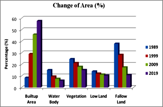
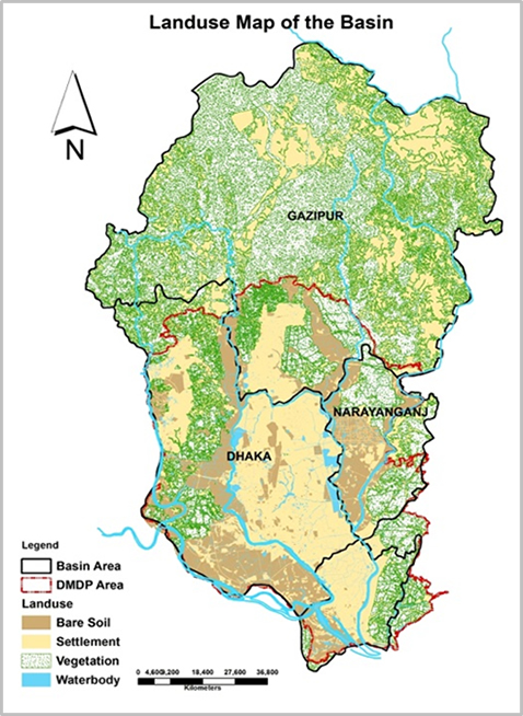
It is clear that over the years (1989 to 2009) Builtup area has increased in huge percentage (from 8.4% to 46%). It is also noticeable that Fallow land has decreased in high rate (from 38% to 17%). Other land cover types have decreased in a very small amount. The predicted map of 2019 reveals that 58% of the total area will be occupied by Builtuparea cover type. On the other hand, water body (6%) and fallow land (11%) types are going to decrease in a significant way. The following figure showing the landuse of the basin and also the landuse pattern of Dhaka Metropolitan Development Plan (DMDP) area.
References and further reading:
Kabir, A., Parolin, B. (2012) Planning and Development of Dhaka – A story of 400 years, University of new south wales, Kensington, NSW 2052, Australia.
Community report, Zila: Dhaka, June 2012, Population and housing census 2011, Bangladesh bureau of statistics Statistics and informatics division, Ministry of planning, Government of the people’s republic of Bangladesh.
Community report, Zila: Gazipur, June 2012, Population and housing census 2011, Bangladesh bureau of statistics Statistics and informatics division, Ministry of planning, Government of the people’s republic of Bangladesh.
Community report, Zila: Narayanganj, June 2012, Population and housing census 2011, Bangladesh bureau of statistics Statistics and informatics division, Ministry of planning, Government of the people’s republic of Bangladesh.
DWASA (2012) Management information system (MIS) report, http://www.dwasa.org.bd/
Hoque, M. A. (2004) Hydrostratigraphy and aquifer piezometry of Dhaka City, Postgraduate Thesis, Institute of Water and Flood Management, BUET, Dhaka, Bangladesh, 37 pp.
Hossain, F. et. al. (2013) Water Resources Vulnerability in the Context of Rapid Urbanization of Dhaka City (a South Asian Megacity), Elsevier Inc., USA.
Majumder, J. R. (2011) A snapshot of socio-economic development of Bangladesh Looking from multiple perspectives.
Rahman, M. A. et al. (2013) Hydrogeological analysis of the upper Dupi Tila Aquifer, towards the implementation of a managed aquifer-recharge project in Dhaka City, Bangladesh, Hydrogeology Journal 21: 1071–1089, Springer-Verlag Berlin Heidelberg, Germany.
Rahman, S., Hossain, F. (2008) Spatial assessment of water quality in peripheral rivers of Dhaka City for optimal re-location of water intake point. Water Resour Manag, 22: 377–391.
Statistical Year Book of Bangladesh (2010) Bangladesh bureau of statistics Statistics and informatics division, Ministry of planning, Government of the people’s republic of Bangladesh.