San Carlos River Basin, northeastern Costa Rica
Climate and Hydrology
The San Carlos river basin exhibits a typical humid tropical climate with a mean annual rainfall of close to 3000mm (Figure 6). The climate is characterized by constantly high humidity and rainfall almost all year round, with less rainfall between March and April (Figure 7). The headwaters close to the continental divide are influenced by precipitation patterns associated with the Pacific slope reflecting more seasonality, which usually presents rainfall between May and November and a dry season ranging from December to April (Birkel et al., 2020). The lowlands of the San Carlos are clearly influenced by the Caribbean Sea and the constant northeastern trade wind activity and moisture transport.
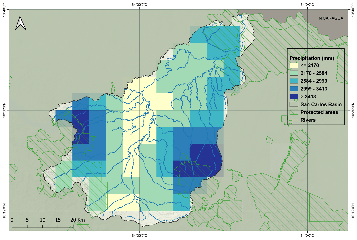
Figure 6. Mean annual precipitation of the San Carlos River basin using CHIRPSv2 (Funk et al., 2015).
Despite the humid tropical climate, droughts in the basin are frequent, such as recently from December 2018 to May 2019 (Barrantes, 2019). Streamflow measurements were compared to historical hydrometeorological data and the results showed that various factors caused a significant hydrological drought, such as El Niño (Figure 7) and less moisture transport from the Caribbean Sea due to increased sea surface temperature.
The average air temperature is around 23°C (Rojas, 2011). The mean annual streamflow of the San Carlos river for the period 1973-2003 is 2383mm year -1 with a standard deviation of 428mm; groundwater was estimated to contribute around 70% to total streamflow. The mean annual actual evapotranspiration (ETA) is estimated to be 1300mm with a standard deviation of 123mm. The ETA is on average 78% of the potential evapotranspiration (ETP). Figure 7 illustrates the most recent hydrological drought of the San Carlos river close to the catchment outlet after a dry wet season and in comparison, to other El Niño periods with monthly precipitation for selected dry years between 1982 and 2019.
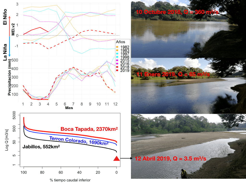
Figure 7. Historic comparison of the most recent hydrological drought in the San Carlos basin using the Multivariable El Niño Index (MEI, upper panel, https://www.esrl.noaa.gov/psd/enso/mei.ext/), precipitation from 1981 to 2017 (middle panel, https://climateserv.servirglobal.net/) and streamflow from 1973 to 2003 (lower panel, Instituto Costarricense de Electricidad). Red lines represent 2018. Pictures: Christian Birkel.
References
Barrantes, V.J. (2019). Drought in the northern area goes beyond the El Niño phenomenon. CAMPUS Magazine, September 2019 edition, National University of Costa Rica (UNA). Recovered from: http://www.campus.una.ac.cr/ediciones/2019/setiembre/2019setiembre_pag04.html
Birkel, C. et al. (2020). Headwaters drive streamflow and lowland tracer export in a large-scale humid tropical catchment. University Space for Advanced Studies (UCREA), University of Costa Rica (UCR). Recovered from: https://onlinelibrary.wiley.com/doi/abs/10.1002/hyp.13841
Correa, A. (2020) Blogs of the European Union of Geosciences, EGU Blogs. Featured catchment series: The San Carlos Catchment in northeast Costa Rica, a multi-scale hydrological observatory to leapfrog data scarcity in the tropics. Recovered from: https://blogs.egu.eu/divisions/hs/2020/02/19/san-carlos-catchment/
Water direction (2020). Public report: Flow assigned by use (total) per basin (San Carlos river basin). Ministry of Environment and Energy (MINAE). Recovered from: http://www.da.go.cr/rp/reportOptions.action?exportType=0&submitRun=Ejecutar&reportId=24747
Fick, S. & Hijmans, R. (2017). WorldClim 2: new 1km spatial resolution climate surfaces for global land areas. Recovered from: https://www.worldclim.org/data/worldclim21.html
National Forest Finance Fund, FONAFIFO (2012). Costa Rica Forest Coverage Study 2009-2010. Recovered from: https://www.sirefor.go.cr/pdfs/tematicas/Cobertura_Boscosa/Estudio_de_Cobertura_Forestal_2010_v2_0512.pdf
Costa Rican Electricity Institute, ICE (2017). Power generation expansion plan 2016 – 2035. Recovered from: https://www.grupoice.com/wps/wcm/connect/beb21101-9c67-4acf-964e-c7a00f682040/PEG+2016-2035.pdf?MOD=AJPERES&CVID=lPcDy1N
Instituto Metereologico Nacional, IMN (No date). Climate Atlas of Costa Rica. Recovered from: https://www.imn.ac.cr/en/atlas-climatologico
National Institute of Statistics and Census, INEC (2014). VI National Agricultural Census. Recovered from: https://www.inec.cr/censos/censo-agropecuario-2014
Rojas, N. (2011). Study of Costa Rica's watersheds. Recovered from: http://cglobal.imn.ac.cr/index.php/publications/estudio-de-las-cuencas-hidrograficas-de-costa-rica/
Rodríguez, F. (No date). The San Carlos river basin. Historical, economic, social and environmental characterization. Studies on the San Carlos River Basin, Costa Rican Institute of Technology. Recovered from: https://www.academia.edu/2245967/ESTUDIOS_SOBRE_LA_CUENCA_DEL_R%C3%8DO_SAN_CARLOS
United Nations Development Programme, PNUD (2018). Human Development Index (IDH). Recovered from: https://www.cr.undp.org/content/costarica/es/home/library/indice-de-desarrollo-humano--idh-.html
National Territorial Information System, SNIT (2020). OGC Services. National Geographic Institute (IGN), Costa Rica. Recovered from: https://www.snitcr.go.cr/ico_servicios_ogc