LIMARÍ (CHILE)
Water Users/Stakeholders
In the case of the Limarí basin, there are mainly surface water users associations and the provider for rural water supply (APR: Agua potable rural) usually linked to ground water extraction. Typically owners of ground water rights act individually without being related to organizations. Only recently (since 2 years) so called “Comunidades de Aguas Subterráneas” are being discussed and formed, especially north of the region of Coquimbo, since there the main source of water is groundwater. These formations are voluntary, but now also promoted by public stakeholders (CNR/DGA). It’s something recently and laws or norms are not existent so far: the process started out of the need of the users (privates) and its mainly form there that they are pushing the process and seeking for support. In the Limari basin until now they are no existent.
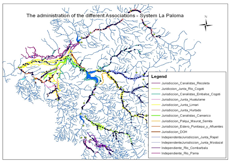
The organizations in the basin with major tradition are the ones belonging to the Paloma system (nine organizations), as well the state agencies (DOH, DGA). Indeed, the DOH (Direccion de Obras Hidraulicas) has been responsible for the largest reservoir, La Paloma during the last almost 40 years, as well as for the “canal Matriz” (main distribution canal). In 2008 a first memorandum of understanding (La Paloma, 2008) was signed between the state agencies, DOH and CNR and the private farmer organizations to be agreed upon to prepare the final transfer of the reservoir from state administration to the private organizations. This has been finalized around September 2012; the private organization had/have to find a form to manage the system. Now the macro-organization is called CASEP (Comunidades de aguas de embalse La Paloma), before that they were called: El cuerpo colegiado. All organizations of the System finally signed although not all are participating actively. Due to personal conversation of some of the stakeholders, until now there is no definition of the legal entity, or let’s say which legal status should the macro organization get etc. Unfortunately even though the transfer went with a lot of details the very important detail of how to organize it hasn’t been defined so far.
The Paloma System, a set of three reservoirs (La Paloma, Recoleta, and Cogotí) totalizing ca. 1,000 Mm3, consists basically of two different subsystems, the natural and the artificial system. In a simplified way, the “Juntas de Vigilancias” (i.e. river surveillance boards) are organizations dealing with the natural riverbed (four organisations), while the “Asociaciones de Canalistas” and “Comunidades de Aguas” refer on artificial aqueducts (five organisations). The latter are also responsible for irrigation in land areas above the channels.
Out of compiled GIS data (CEAZA, GORE, Rodhos, 2006, Alfaro, 2001, and field data from the organisations) the following map with the different administration areas could be generated. Herewith it can be distinguished which one are parts of the “La Paloma System”.
References and further reading:
Álvarez, P., Kretschmer, N., Oyarzún, R. (2006) Water Management for Irrigation in Chile: Causes and Consequences, paper presented at the international water fair “Wasser Berlin 2006”.
CIREN (1994) Estudio Agrológico de los valles de Choapa, Illapel y Limarí, Centro de Información de Recursos Naturales.
CIREN (2012) Describciones de suelos, Materiales y Simbolos, Publicación CIREN no. 129, Propiedad Intelectual N°151.231, ISBN956-7153-65-5, Esta edición complementa la cartografía digital de suelos, actualizada sobre 215 ortoimágenes satelitales año 2010-2011 en escala de salida 1:10.000 (the map in the annex shows the area of study).
DGA (2004) Diagnóstico y Clasificación de los Cursos y Cuerpos de Agua según Objetivos de Calidad, Cuenca del Río Limarí, elaborado por CADE‐IDEPE Consultores en Ingeniería.
FAO (2002) Digital Soil Map of the World and derived soil properties, Land and Water Digital Media Series #1 rev 1. FAO, Rome.
INE (2007) Censo Agropecuario (2007), www.inecoquimbo.cl, accessed: 18.04.2012.
INIA (2009) Tierra adentro, frutales y viñas, Valle del Limarí, un aporte a la fruticultura chilena, http://www.inia.cl/link.cgi/, accessed: 12.03.2012.
Oyarzún, R., Arumí, J. L., Álvarez, P., Rivera, D. (2008) Water use in the Chilean agriculture: current situation and areas for research development, in: Sorensen ML (ed) Agricultural water management trends, Nova Publishers, New York, 213-236.
Oyarzún, R. (2010) Estudio de caso: Cuenca del Limarí, Región de Coquimbo, Chile, Compilación Resumida de Antecedentes, Centro de Estudios Avanzados en Zonas Aridas-Universidad de la Serena (CEAZA-ULS).
Parga, F., León, A., Vargas, X., Fuster, Y. (2006) El índice de pobreza hídrica aplicado a la cuenca del río Limarí en Chile semiárido, Eval. Usos del Agua en Tierras Secas de Iberoamérica, 12: 93-109.
Strauch, G., Oyarzún, R., Reinstorf, F., Oyarzún, J., Schirmer, M., Knöller, K. (2009) Interaction of water components in the semi-arid Huasco and Limarí river basins, North Central Chile, Advances in Geosciences, 22, 51–57.