imperial RIVER BASIN (chile)
Socioeconomic Development
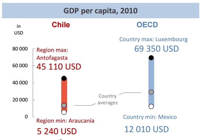
The Imperial River Basin belongs administratively to the Araucanía region, which is rich in natural resources, forestry, livestock, farm and with a recent boom in international tourism due to its natural beauties (volcanoes, ancient forests, ski resorts, lakes, rivers, fishing, spas, mountains, etc). Despite its potential wealth, it is the poorest region of Chile (see Figure 6), with high rates of poverty and socio-economic inequality (HDI=0.686).
Population
The Imperial River Basin is a dynamic region in Chile, with a constantly growing population. According to the National Institute for Statistics (INE), the total population of the Araucanía region increased from 781 242 in 1992 up to 970 722 in 2012 (INE, 2015) (24% in 20 years). Most of the population is concentrated mainly in 4 out of 32 districts: Temuco (268 720 inhabitants), Padre Las Casas (70 944 inhabitants), Angol (50 910 inhabitants) and Villarrica (50 706 inhabitants), representing a 48,6 % of the population in the region (MOP, 2012). According to the 2002 Census, the population density of the region is 28,49 in/km2 (MOP, 2012), and 67,7% of the population lives in urban areas and 32,3% in rural ones. The urban population is constantly increasing while the rural population is decreasing (INE, 2015).
In the Araucanía region there is a high dispersion of the Human Development Index (HDI), with communes as Temuco, Pucón, Angol and Villarrica showing high and very high indices in comparison to the rest of Chile, and communes as Carahue, Freire, Teodoro Schmidt show significant levels of rurality and poverty. The percentage of indigenous population, geographical location and rurality tend to be factors that directly influence the human development index. Very likely the high HDI of Temuco and Angol is explained by its condition of being the capital city of their respective province, while in the case of Pucón and Villarrica it might be associated to the active development of the tourism sector (MOP, 2012).
Economic sectors
The economy of the Araucanía region relies heavily on agriculture and forestry, as primary sectors, which is consistent with the high rurality of the population. In the last decades, the regional economy has been diversified, sustained by activities such as commerce, services, sustainable tourism, manufacturing, agriculture, forestry and agroindustries. The flow of private domestic and foreign investment is constantly growing, and has developed a strong export capacity of regional entrepreneurs in several areas where comparative advantages are already consolidated. In the period 2008-2010, the activities with greater economic contribution to the Gross Domestic Product (GDP) of the region have been personal services, agriculture and forestry, and commerce (MOP, 2012).
References and further reading:
Banco Mundial (2011) Chile: Diagnóstico de la gestión de los recursos hídricos. Banco Mundial, Departamento de Medio Ambiente y Desarrollo Sostenible, Región para América Latina y el Caribe. Available on http://www.dga.cl/eventos/Diagnostico%20gestion%20de%20recursos% 20hidricos%20en%20Chile_Banco%20Mundial.pdf. [Accessed on Jun 10th 2016].
CADE-IDEPE (2004) Diagnóstico y Clasificación de los Cursos y Cuerpos de Agua Según Objetivos de Calidad. Cuenca del Río Imperial. Technical Report. Ministerio de Obras Públicas, Dirección General de Aguas. Elaborado por: Cade-Idepe Consultores en Ingeniería. Available on http://www.sinia.cl/1292/articles-31018_Imperial.pdf.
CONIC-BF (2010) Mejoramiento y ampliación red de aguas subterráneas regiones VII a X. Informe Final. Ministerio de Obras Públicas, Dirección General de Aguas, División de Estudios y Planificación. Elaborado por: CONIC-BF Ingenieros Civiles Consultores.
CR2 (2015) Informe a la Nación: La Megasequía. Centro de Ciencia del Clima y la Resiliencia (CR2), Universidad de Chile. Available on http://www.uchile.cl/publicaciones/117420/informe-a-la-nacion-la-megasequia-2010-2015. [Accessed on Jun 10th, 2016].
DMC (2015) Descripción Climatológica Región de la Araucanía. Dirección Meteorológica de Chile (DMC). Available on http://www.meteochile. cl/climas/climas_novena_region.html. [Accessed on Dec 10th 2015].
Huber, A., Iroumé, A., Bathurst, J. (2008) Effect of Pinus radiata plantations on water balance in Chile. Hydrological Processes 22, 142–148. doi:10. 1002/hyp.6582.
Huber, A., Iroumé, A., Mohr, C., Frêne, C. (2010) Efecto de plantaciones de Pinus radiata y Eucalyptus globulus sobre el recurso agua en la Cordillera de la Costa de la región del Bíobío, Chile. Bosque (Valdivia) 31, 219–230. doi:10.4067/S0717-92002010000300006.
Huber J, A., Trecaman V, R. (2000) Efecto de una plantacin de Pinus radiata en la distribucin espacial del contenido de agua del suelo. Bosque (Valdivia) 21, 37–44.
Huber J, A., Trecaman V, R. (2004) Eficiencia del uso del agua en plantaciones de Pinus radiata en Chile. Bosque (Valdivia) 25, 33–43. doi:10.4067/S0717-92002004000300004.
INE (2007) Censo Agropecuario 2007. Instituto Nacional de Estadísticas (INE). Available on http://www.ine.cl/canales/chile_ estadistico/censos_agropecuarios/censo_agropecuario_07.php. [Accessed on Jun 10th 2016].
INE (2015) Compendio Estadístico-Región de la Araucanía 2015.Instituto Nacional de Estadística (INE). Dirección Regional de la Araucanía. Temuco, Chile. Available on http://www.inearaucania.cl/archivos/files/pdf/SistemaEstadisticoRegional/Compendio%20Estad%C3%ADstico% 20Regional%202015%20-%20La%20Araucan%C3%ADa.pdf. [Accessed on Jun 10th 2016].
INFOR (2014) Antecedentes Generales y Recurso Forestal Región de la Araucanía 2014. Instituto Forestal (INFOR). Available on http://wef.infor.cl/estadisticas_regionales/estadisticasregionales.php. [Accessed on Jun10th 2016].
INFOR (2015) El sector forestal chileno 2015. Instituto Forestal (INFOR). Available on http://wef.infor.cl/sector_forestal/ sectorforestal.php#/44. [Accessed on Jun 10th 2016].
Little, C., Lara, A., McPhee, J., Urrutia, R. (2009) Revealing the impact of forest exotic plantations on water yield in large scale watersheds in South-Central Chile. Journal of Hydrology 374, 162–170. doi:10.1016/ j.jhydrol.2009.06.011.
MOP (2012) Plan Regional de Infraestructura y Gestión del Recurso Hídrico al 2021. Resumen Ejecutivo. Ministerio de Obras Públicas, Región de la Araucanía. Available on http://www.dirplan.cl/planes/regional/ download/PRIGRH_Region_Araucania.pdf. [Accessed on Jun 10th 2016].
Quiroga, T.G. (1987) Investigación tecnológica de Riego. Instituto de Investigaciones Agropecuarias (Chile). Estación experimental Carillanca. Programa Riego y Drenaje. Temuco. Informe Final. p 12.
Scott, D.F., Prinsloo, F.W. (2008) Longer-term effects of pine and eucalypt plantations on streamflow. Water Resources Research, 44, W00A08. doi:10.1029/2007WR006781.
Sobarzo, C.T. (2014) Adaptación al cambio climático de la gestión hídrica. Master’s thesis. Magster en Gestión y Polticas Públicas. Universidad de Chile. Estudios de Caso Nro 129.