Dhaka River Basin (Bangladesh)
Hydrology
Surfacewater
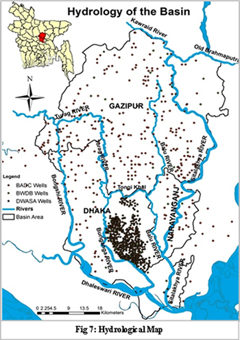
Over the last 150 years there were no major avulsions of the main rivers of Bangladesh. But declining and enlarging of the main rivers occur in a large-scale. At the beginning of the 16th century, the Mughals, in fact the first, established Dhaka city, the central part of the basin. The expansion of Dhaka city was mainly in and around the river Burigunga. The canals within the mega city Dhaka & the rivers surround the city are acting as natural drainage system, water reservoir and the river route. These canals are Begunbari khal, Segunbagicha khal, kallayanpur khal, Dholai khal etc. The surrounding rivers are the Buriganga, the Shitolakhya, the Balu, the Turag and the Dhaleshari. Although the total basin area consists of Balu, Bongshi,Buriganga, Dhaleswari, Sitalakhya, Tongi Khal and Turag rivers.
Groundwater
The basin is completely dependent on the ground water resources while all other sources of fresh water are almost dead or unusable. Climate change increases variability in precipitation, soil moisture and surface water in developing countries like Bangladesh. Recent days Bangladesh has prime concern to sustainably manage its ground water as it is tend to become scarce. In Dhaka river basin area, surface water withdrawal from adjacent rivers is not a proved feasible option because of high levels of industrial and domestic pollution from unregulated waste disposal. Dhaka city is dependent primarily on groundwater for the urban water supply. Presently Dhaka Water and Sanitation Authority (DWASA, 2012) obtains 83 % of the drinking water from groundwater sources via 627 deep tube-wells in the metropolis of Dhaka City and Narayangonj, and 17 % is supplied by three major surface water treatment plants. Ground water of Dhaka city has been drawn down significantly because of overexploitation and also the pressing demand from the urbanization and it is also evident that the rate of water-level drop in the city area is about 2.5 m/year in the recent years.
Aquifer and aquifer properties
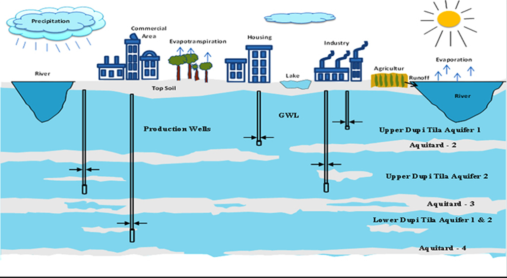
The Basin area is characterized by Quaternary alluvial sequences of the Madhupur tract, which is an elevated Pleistocene terrace that surrounds floodplains of the Jamuna, Ganges and Meghna rivers. The primary aquifer of Dhaka City consists of unconsolidated sediments of the DupiTila Formation, which are overlain by the Modhupur clay, an approximately 48-m-thick aquitard. The DupiTila formation is mainly composed of fine-to-coarse-grained sands. The transmissivity (T) of the DupiTila Formation (500– 2,000 m2/d; EPC-MMP 1991) is less than that of Holocene to late Pleistocene alluvial sands (3,000–5,000 m2/d, Davies 1994) at similar depth. The hydraulic conductivity of the DupiTila Formation is low (15–30 m/d; EPC-MMP 1991), which is attributed to the formation of secondary minerals by weathering (MMI-HTS 1992 and the occurrence of clay lenses. Though, aquifers are relatively homogenous in respect of aquifer properties and materials.
Table: Average thickness of the different hydrogeological layers at Dhaka basin
| Layers |
Average Thickness (m) |
Depth |
| Top soil | 3 | 0-3 |
| Aquitard - 1 | 11 | 3-14 |
| Upper Dupitila Aquifer 1 | 23 | 14-37 |
| Aquitard - 2 | 21 | 37-58 |
| Upper Dupitila Aquifer 2 | 97 | 58-155 |
| Aquitard - 3 | 16 | 155-171 |
| Lower Dupitila Aquifer 1 | 57 | 171-228 |
| Aquitard - 4 | 16 | 228-244 |
| Lower Dupitila Aquifer 2 | 43 | 244-500 |
References and further reading:
Kabir, A., Parolin, B. (2012) Planning and Development of Dhaka – A story of 400 years, University of new south wales, Kensington, NSW 2052, Australia.
Community report, Zila: Dhaka, June 2012, Population and housing census 2011, Bangladesh bureau of statistics Statistics and informatics division, Ministry of planning, Government of the people’s republic of Bangladesh.
Community report, Zila: Gazipur, June 2012, Population and housing census 2011, Bangladesh bureau of statistics Statistics and informatics division, Ministry of planning, Government of the people’s republic of Bangladesh.
Community report, Zila: Narayanganj, June 2012, Population and housing census 2011, Bangladesh bureau of statistics Statistics and informatics division, Ministry of planning, Government of the people’s republic of Bangladesh.
DWASA (2012) Management information system (MIS) report, http://www.dwasa.org.bd/
Hoque, M. A. (2004) Hydrostratigraphy and aquifer piezometry of Dhaka City, Postgraduate Thesis, Institute of Water and Flood Management, BUET, Dhaka, Bangladesh, 37 pp.
Hossain, F. et. al. (2013) Water Resources Vulnerability in the Context of Rapid Urbanization of Dhaka City (a South Asian Megacity), Elsevier Inc., USA.
Majumder, J. R. (2011) A snapshot of socio-economic development of Bangladesh Looking from multiple perspectives.
Rahman, M. A. et al. (2013) Hydrogeological analysis of the upper Dupi Tila Aquifer, towards the implementation of a managed aquifer-recharge project in Dhaka City, Bangladesh, Hydrogeology Journal 21: 1071–1089, Springer-Verlag Berlin Heidelberg, Germany.
Rahman, S., Hossain, F. (2008) Spatial assessment of water quality in peripheral rivers of Dhaka City for optimal re-location of water intake point. Water Resour Manag, 22: 377–391.
Statistical Year Book of Bangladesh (2010) Bangladesh bureau of statistics Statistics and informatics division, Ministry of planning, Government of the people’s republic of Bangladesh.