Imperial RIVER BASIN (chile)
Hydrology
Surface water
The headwaters of the Imperial River Basin are located to the west of the upper BioBio River Basin, from which it is separated by a series of mountain ranges, as Las Raíces and Sierra Nevada, which prevents taking advantage of water coming from the highest mountains. However, it receives the contributions of snowy peaks as the Llaima (3 124 m a.s.l.), Tolhuaca (2 789 m a.s.l.) and Lonquimay (2 822 m a.s.l.) volcanoes (CADE-IDEPE, 2004), the latter being where the main river originates.
The Imperial river has a total length of 230 km from its head in the Andes mountain range to its mouth at the Pacific Ocean, nearby Puerto Saavedra. It is originated by the confluence of the Cautín and Chol Chol rivers, nearby Nueva Imperial, with the Cautín river coming from the east and the Chol Chol coming from the north (see Figure 1) (CADE-IDEPE, 2004). The Cautín river is the main tributary of the Imperial, in terms of streamflow amount. It begins in the western part of the Las Raíces mountain range and cross through all the central valley, with a total length of 174 km and a drainage area of 3 100 km2. The most important tributary of the Cautín is the Quepe river, which originates from the Quepe lagoon, in the western of hillslope of Llaima volcano, to finally join the Cautín nearby Almagro. This tributary has a total length of 112 km, with many secondary streams, particularly in the southern riverside (CADE-IDEPE, 2004).
The Chol Chol tributary begins in the eastern slope of the Nahuelbuta mountain range, flowing mostly to the South. Its drainage area is about 6 180 km2, almost the double of the Cautín river (see Figure 1). One of its tributaries is the Traiguén river, which originates nearby Victoria, in the confluence of two secondary streams. The Quino river, joins the Traiguén, giving place to the Colpi (or Panqueco) river, which is one of the main tributaries of Chol Chol (CADE-IDEPE, 2004). Finally, another important tributary is the Lumaco river, which begins in the Nahuelbuta mountain range and then joins the Quillén river close to Galvarino, giving place to the Chol Chol river (CADE-IDEPE, 2004).
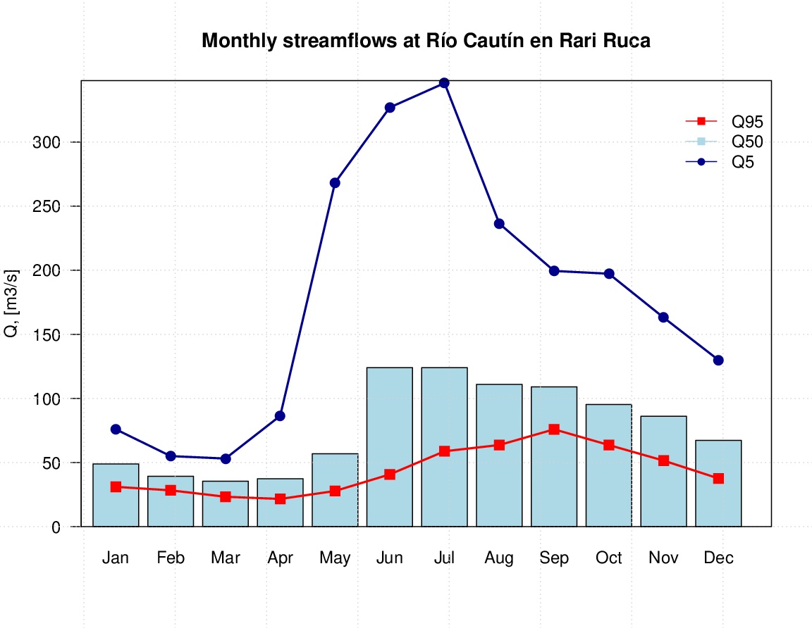
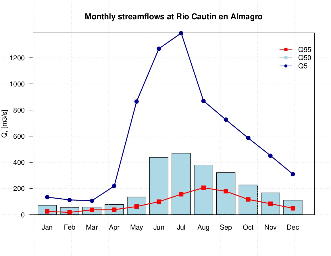
The average annual flow of the Cautín river is 101,3 m3/s at the outlet of the Andean area, ranging from 46 m3/s in March up to 160 m3/s in July; while at the confluence with the Imperial river the average monthly flow is 277 m3/s, ranging from 79 m3/s in March up to 592 m3/s in July. Meanwhile, the Chol Chol river drains the eastern slopes of the Coastal mountain range and the northern part of the Intermediate Depression and the Andes mountain range. Its average annual flow before joining the Imperial River is 145 m3/s, ranging from 22 m3/s in March up to 385 m3/s in July.
Hydrogeology
The upper part of the Imperial River Basin is characterised by low permeabilities, due to the rocky formations of volcanic origin, created in the Tertiary and Quaternary period, the same period where the Tolhuaca, Lonquimay, Sierra Nevada and Llaima volcanoes were also originated. The rocky formations are constituted by andesites and ignimbrites which adopt the form of lava flows, breccias, and low permeability tuffs (CADE-IDEPE, 2004).
Associated to the Cautín river there is an aquifer, which flows towards the Intermediate Depression throughout non-consolidated materials formed mainly by alluvial deposits. In this region the groundwater level is close to the surface, reaching a depth of only 6 metres, as measured by the DGA well in Lautaro. From Lautaro on, the main aquifer is divided in two parts: one of them follows the direction of Quillén and Quino rivers (in the northern part); whilst the other one follows the direction of the Cautín river (southern direction). The latter one close to Temuco turns into the coast, joining the eastern aquifer which flows parallel to the Quepe river. Nearby Nueva Imperial, the aquifers coming from north and east, flowing close to the Imperial River throughout Paleozoic rocks of near zero permeability, up to the mouth in Puerto Saavedra. This last part of the aquifer is characterised by a low depth of freatic level and a high productivity of wells (CADE-IDEPE, 2004).
References and further reading:
Banco Mundial (2011) Chile: Diagnóstico de la gestión de los recursos hídricos. Banco Mundial, Departamento de Medio Ambiente y Desarrollo Sostenible, Región para América Latina y el Caribe. Available on http://www.dga.cl/eventos/Diagnostico%20gestion%20de%20recursos% 20hidricos%20en%20Chile_Banco%20Mundial.pdf. [Accessed on Jun 10th 2016].
CADE-IDEPE (2004) Diagnóstico y Clasificación de los Cursos y Cuerpos de Agua Según Objetivos de Calidad. Cuenca del Río Imperial. Technical Report. Ministerio de Obras Públicas, Dirección General de Aguas. Elaborado por: Cade-Idepe Consultores en Ingeniería. Available on http://www.sinia.cl/1292/articles-31018_Imperial.pdf.
CONIC-BF (2010) Mejoramiento y ampliación red de aguas subterráneas regiones VII a X. Informe Final. Ministerio de Obras Públicas, Dirección General de Aguas, División de Estudios y Planificación. Elaborado por: CONIC-BF Ingenieros Civiles Consultores.
CR2 (2015) Informe a la Nación: La Megasequía. Centro de Ciencia del Clima y la Resiliencia (CR2), Universidad de Chile. Available on http://www.uchile.cl/publicaciones/117420/informe-a-la-nacion-la-megasequia-2010-2015. [Accessed on Jun 10th, 2016].
DMC (2015) Descripción Climatológica Región de la Araucanía. Dirección Meteorológica de Chile (DMC). Available on http://www.meteochile. cl/climas/climas_novena_region.html. [Accessed on Dec 10th 2015].
Huber, A., Iroumé, A., Bathurst, J. (2008) Effect of Pinus radiata plantations on water balance in Chile. Hydrological Processes 22, 142–148. doi:10. 1002/hyp.6582.
Huber, A., Iroumé, A., Mohr, C., Frêne, C. (2010) Efecto de plantaciones de Pinus radiata y Eucalyptus globulus sobre el recurso agua en la Cordillera de la Costa de la región del Bíobío, Chile. Bosque (Valdivia) 31, 219–230. doi:10.4067/S0717-92002010000300006.
Huber J, A., Trecaman V, R. (2000) Efecto de una plantacin de Pinus radiata en la distribucin espacial del contenido de agua del suelo. Bosque (Valdivia) 21, 37–44.
Huber J, A., Trecaman V, R. (2004) Eficiencia del uso del agua en plantaciones de Pinus radiata en Chile. Bosque (Valdivia) 25, 33–43. doi:10.4067/S0717-92002004000300004.
INE (2007) Censo Agropecuario 2007. Instituto Nacional de Estadísticas (INE). Available on http://www.ine.cl/canales/chile_ estadistico/censos_agropecuarios/censo_agropecuario_07.php. [Accessed on Jun 10th 2016].
INE (2015) Compendio Estadístico-Región de la Araucanía 2015.Instituto Nacional de Estadística (INE). Dirección Regional de la Araucanía. Temuco, Chile. Available on http://www.inearaucania.cl/archivos/files/pdf/SistemaEstadisticoRegional/Compendio%20Estad%C3%ADstico% 20Regional%202015%20-%20La%20Araucan%C3%ADa.pdf. [Accessed on Jun 10th 2016].
INFOR (2014) Antecedentes Generales y Recurso Forestal Región de la Araucanía 2014. Instituto Forestal (INFOR). Available on http://wef.infor.cl/estadisticas_regionales/estadisticasregionales.php. [Accessed on Jun10th 2016].
INFOR (2015) El sector forestal chileno 2015. Instituto Forestal (INFOR). Available on http://wef.infor.cl/sector_forestal/ sectorforestal.php#/44. [Accessed on Jun 10th 2016].
Little, C., Lara, A., McPhee, J., Urrutia, R. (2009) Revealing the impact of forest exotic plantations on water yield in large scale watersheds in South-Central Chile. Journal of Hydrology 374, 162–170. doi:10.1016/ j.jhydrol.2009.06.011.
MOP (2012) Plan Regional de Infraestructura y Gestión del Recurso Hídrico al 2021. Resumen Ejecutivo. Ministerio de Obras Públicas, Región de la Araucanía. Available on http://www.dirplan.cl/planes/regional/ download/PRIGRH_Region_Araucania.pdf. [Accessed on Jun 10th 2016].
Quiroga, T.G. (1987) Investigación tecnológica de Riego. Instituto de Investigaciones Agropecuarias (Chile). Estación experimental Carillanca. Programa Riego y Drenaje. Temuco. Informe Final. p 12.
Scott, D.F., Prinsloo, F.W. (2008) Longer-term effects of pine and eucalypt plantations on streamflow. Water Resources Research, 44, W00A08. doi:10.1029/2007WR006781.
Sobarzo, C.T. (2014) Adaptación al cambio climático de la gestión hídrica. Master’s thesis. Magster en Gestión y Polticas Públicas. Universidad de Chile. Estudios de Caso Nro 129.