Vu Gia Thu Bon Information Centre (Vietnam)
Natural Environment
Vu Gia Thu Bon river basin consists of different Vietnamese provinces, namely Quang Nam, Da Nang, Kon Tum and Quang Ngai and extends from 14°90´to 16°20´N and from 107°20´to 108°70´E. The River Basin area covers 10,350 km2 and is bordering the Thua Thien-Hue Province in the North,the South-China Sea in the East, in the South the Kon Tum and Quang Ngai Province and in the West the Lao P.D.R. border, which mostly fits the catchment boundary.
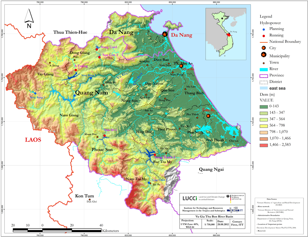
The VGTB River Basin is fringed by the Bach Ma Mountain Range in the North with peaks over 1,000 m, the South Truong Son mountains in the West with peaks over 2,000 m and by the Kon Tum mountain mass in the South running out to the sea with the Ngoc Linh mountain as the highest peak in the whole Watershed (2,598 m). The topography divides the area in three major landscapes from West to East (DoNRE, 2011; Dung and Phuong, 2010; ICEM, 2008).
Highlands
The mountainous upland is characteristic for the western Districts of Da Nang (Hoa Vang), Quang Nam (Tay Giang, Nam Giang, Phuoc Son, NamTra My) and Kon Tum (Dac Glei) Province. The Highlands have steep and sloping areas with narrow riverbeds which are not only hardly to access, but also very vulnerable to climate events. Those parts have the highest tree-coverage in the VGTB river basin and show a low agricultural activity. Agriculture, which is due to the low population and the difficult accessibility sparse in this area, is mainly limited to traditional crops like rice, cassava and maize and farming (DoNRE, 2011; Dung and Phuong, 2010; ICEM, 2008).
Midlands
The midlands have in comparison to the highlands lower hills, which range from 100 to 800 m and cover major parts of the Dong Giang, Nam Giang, Dai Loc, Nong Son, Hiep Duc and Bac Tra My District in the Quang Nam province. The hydropower plant planning is based on the natural characteristics of the midlands which comprise changes in the riverbed width and shallowness and forms, together with the highlands, a huge cascade system. The agriculture in the midlands is characterized by slash and burn practices and by rice which is cultivated on slopes. Paddy rice field do not shape the midlands except for the plain areas like plateaus and riparian zones.The large hillside areas, on the other hand, are characterized by production forest, mainly Acacia mangium and Acacia auriculormis which are used for paper production (DoNRE, 2011; Dung and Phuong, 2010; ICEM, 2008).
Lowlands
The coastal area is characterized by narrow plains which are lower than 30 m and sand dunes which are close to the shoreline and range from 0 to more than 10 m. The riverbeds are very shallow in this area, causing extended floods during the rainy season. Areas which show this shallowness are the eastern Districts of the project area; the urban area of the Da Nang province as well as Dien Ban, Hoi An, Duy Xuyen, Que Song, Thang Binh, Phu Ninh, Tam Ky and Nui Thanh district of the Quang Nam province. Rice paddy fields and a complex network of ditches characterize this area. Especially the coastal area stretching from Da Nang to Hoi An has pure sandy beaches which is attractive for national and international tourists (DoNRE, 2011; Dung and Phuong, 2010; ICEM, 2008).
References and further reading:
Haines-Young, R.H., Potschin, M. (2013) Common International Classification of Ecosystem Services (CICES): Consultation on Version 4, August-December 2012, Report to the European Environment Agency.
MEA Millenium Ecosystem Assessment (2005) Ecosystems and human well-being: Current State and Trends Island Press, Washington.
Potschin, M., Haines-Young, R.H. (2011) Ecosystem services: exploring a geographical perspective Progress in Physical Geography 35: 575-594.
Spangenberg, J. H. (2013) The ecosystem service cascade: the influence of purpose, power, and prosperity, benefits and beneficiaries, talk at the Sustainable Land Management Status Conference, Berlin.