Guadiana Basin, Spain/Portugal
Natural Environment
The Guadiana River Basin is a transboundary basin located in Spain and Portugal. It drains a total area of 67.133 km2 and the river has a length of 820 km. The Guadiana river flows westward throguh through the centre and south of Spain and through south-estern Portugal. Finally, the Guadiana river discharges to the Gulf of Cádiz in the Atlantic Ocean (Jafroudi 2018; Llams et al., 2013; Palop-Donat et al., 2020; Tsige et al., 2020).
Topography
The Guadiana Basin stretches from East to West and is bounded by the San Pedro-Toledo Mountains in the North and the Sierra Morena in the South (Tsige et al., 2020). The elevation is predominantly flat, with an average elevation of about 550 m.a.s.l. The highest peak within the basin is the Villuercas peak with a height of 1,601 m (Confederación Hidrográfica del Guadiana; Baena-Ruiz & Pulido-Velazquez, 2020). The DEM of the Guadiana Basin is shown in the map below.
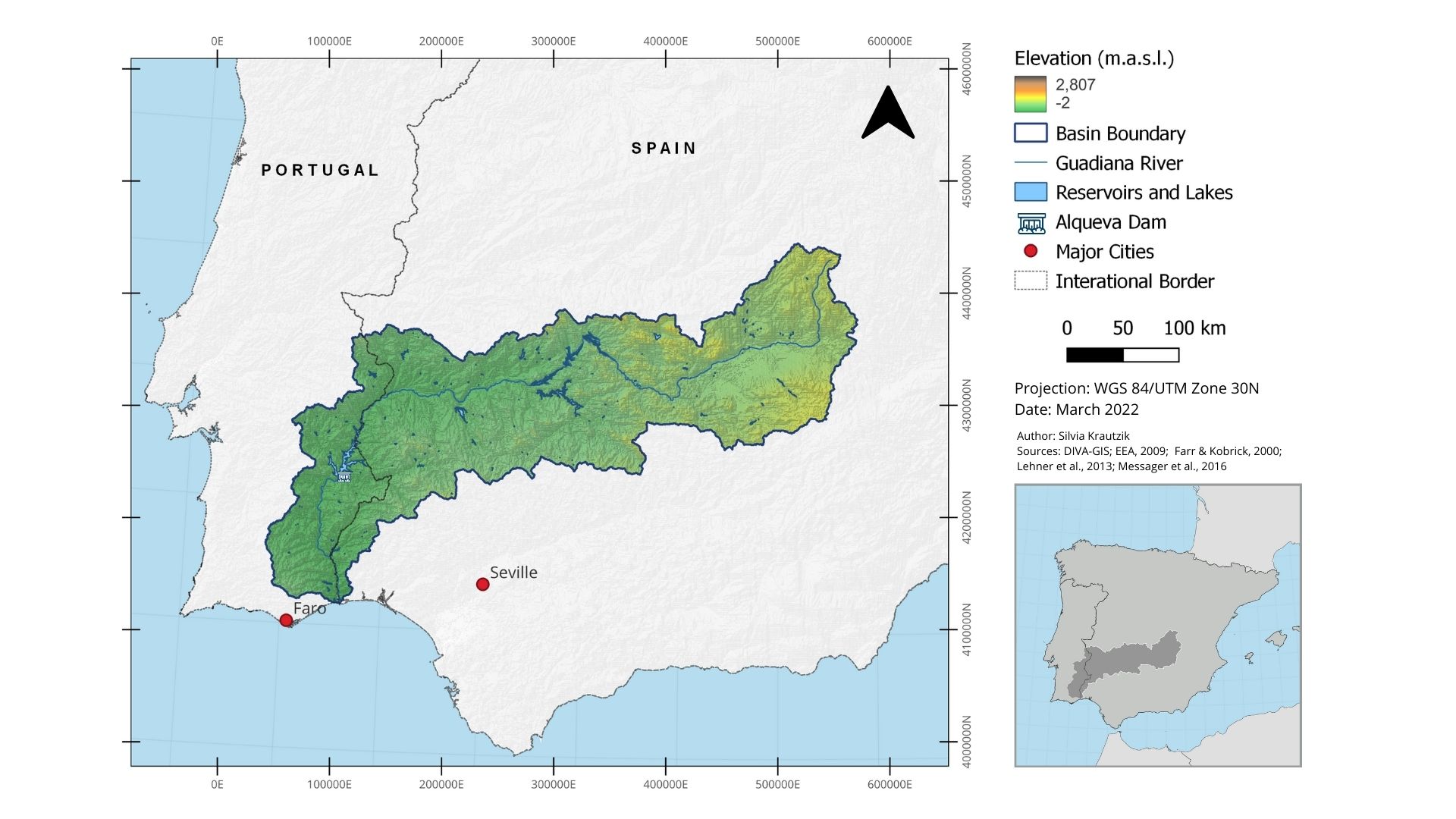
Figure 2: Guadiana basin: Overview and topography.
Geology
The formation and structure of the Guadiana Basin was caused by Alpine tectonics. As a result of these processes, the Guadiana basin can be divided into two geological basins, the Vegas Bajas and Vegas Altas. Both basins were infilled with Cenozoic deposits (Tsige et al., 2020).
Soils
Approximately 80% of the basin's soils are classified as Inceptisol. Other identified soil types incluce Alfisol (Confederación Hidrográfica del Guadiana).
References
Baena-Ruiz, L.; Pulido-Velazquez, D. (2020): A Novel Approach to Harmonize Vulnerability Assessment in Carbonate and Detrital Aquifers at Basin Scale. Water, 12, no. 11: 2971. https://doi.org/10.3390/w12112971
Confederación Hidrográfica del Guadiana: Geología y Geomorfología. Available at: https://www.chguadiana.es/cuenca-hidrografica/medio-natural/biodiversidad/geologia-y-geomorfologia
Jafroudi, M. (2018): Climate change and accommodation of water availability in transboundary rivers: lessons learned from the Guadiana basin. Water Policy, 20(2), wp2018178–. doi:10.2166/wp.2018.178
Llamas, M.R., Varela-Ortega, C., De La Hera, A., Aldaya, M.M., Villarroya, F., Martinez- Santos, P., Blanco-Guiterrez, I., Carmona-Garcia, G., Esteve-Bengoechea, P., De Stefano, L., Hernandez-Mora, N., ZORRILLA, P. (2013): The Guadiana basin. In: Mysiak, J.; Henrikson, H.J.; Sullivan, C.; Bromley, J.; Pahl-Wostl, C. (Ed.): The Adaptive Water Resource Management Handbook, pp. 103-116. Oxford: Taylor and Francis. DOI:https://doi.org/10.4324/9781315065984.
Palop-Donat, C., Paredes-Arquiloa, J., Solera, A., & Andreu Álvarez, J. (2020): Comparing performance indicators to characterize the water supply to the demands of the Guadiana River basin (Spain). In: Hydrological Sciences Journal, 65(7), 1060-1074. doi:https://doi.org/10.1080/02626667.2020.1734812
Tsige, Meaza; Gomez-Ortiz, David; Tejero, Rosa; Garzón-Heydt, Guillermina (2020). Lithostratigraphy of a Cenozoic intra continental basin (Guadiana Basin, SW Spain) by using clay mineral assemblages and geophysical properties. CATENA, 192(), 104588–. doi:10.1016/j.catena.2020.104588