MATA ATLÂNTICA DO RIO: MACACÚ (BRAZIL)
Natural Environment
The Guapi-Macacu River Basin (GMRB) is located within the state of Rio de Janeiro (Brazil), northeast from the Guanabara Bay and the city Rio de Janeiro. The basin has a drainage area of 1,265 km², being the largest contributing basin to the Guanabara Bay, and ranges from 42°32'–43°3'W and 22°21'–22°41’S. The elevation varies from the coastal plain at the bay until the mountain range Serra dos Órgãos at 2,250 m.a.s.l. (Cardoso Fidalgo et al., 2008). The major streams, the Macacu (eastern river) and Guapiaçu (western river) rivers, drain parts of the NE-SW trending Serra dos Órgãos, belonging to the northern part of the mountain range Serra do Mar. The Guanabara Bay and the river valleys of the GMRB can be seen as a trench located between the horsts of the Serra dos Órgãos and the coastal shield. Moreover, the mountain range of the watershed discovers species-rich relicts of the Atlantic Forest (Penedo et al., 2011).

Soils
The main soil types are Cambisols in the mountainous areas, Ferralsols in the lowland area and Fluvisols (alluvial sediments) in the floodplain areas. In the downstream area gleyic soils have developed due to periodical seasonal flooding. Typical for tropical regions is the profound weathering of the substrate, controlled by climate factors, especially high humidity and temperatures.
For instance, Ferralsols (known as Latossolos in Brazil) are typical deeply weathered soils of the humid tropics assembled by low-activity clays and high content of sesquioxides (IUSS Working Group WRB, 2006). These soils have poor chemical fertility and phosphorous retention and need, therefore, sound fertilization schemes for crop production. According to Lumbreras (2008) the predominant Ferralsols in the region are yellow and yellow-red dystrophic soils.
Moreover, Cambisols make generally good agricultural land but they are, in the humid tropics, typically poor in nutrients although richer than associated Ferralsols. However, Cambisols are best kept under forest when present in deep slopes (IUSS Working Group WRB, 2006) which is the case of the GMRB. Fluvisols describe young, azonal soils in alluvial deposits with generally good natural fertility. For instance, agriculture is widely practiced in the river margins of the Macacu and Guapiaçu due to the fertility of the soil. Gleyic soils have developed in the downstream area of the basin due to seasonal flooding. In order to use these soils for agriculture a drainage system is required to lower groundwater table. If this is not possible these soils are best kept under grass or swamp forest (IUSS Working Group WRB, 2006).

Due to the processes of ferralization and desilication, silicum compounds and cations such as Ca2+, Mg2+, K+ and Na+ can be leached out (Penedo et al., 2011). In general, humid tropical soils show low cation exchange capacity (CEC) and, as mentioned before, a poor nutrient content level (Scheffer et al., 2009).
Geology
The Serra dos Órgãos, belonging to the Serra do Mar, defines the northern limit of the Guanabara Graben and of the GMRB. The history of the region is related to the evolution of the so-called Ribeira belt, originated during the Neoproterozoic-Ordovician collision and terrain accretion of the Western Gondwana Supercontinent (Fernandes et al., 2010). The oldest outcropping rocks are Meso- to Neoproterozoic gneisses and calc-silicate rocks (Fernandes et al., 2010). The area was afterwards reactivated through tectonism during the Cretaceous followed by alkaline magmatism resulting in tectonic valleys, sedimentary basins and mountains known as the Continental Rift of Southeastern Brazil (Riccomini et al., 2004; Ferrari, 2001; Fernandes et al., 2010).
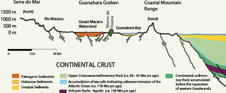
According to Almeida & Carneiro (1998), the Guanabara Graben (see figure where the morphological profile of the Guanabara Graben is shown) belonging to the Continental Rift of Southeastern Brazil, was formed by the lifting of the Serra dos Órgãos which enhanced erosion rates leading to the accumulation of calcareous sediments in the flood plains in the Paleocene. Later, during the Quaternary Period the Guanabara Graben was flooded by the sea. The continental deposits of 200 meter thickness are known as the Macacu and Pré-Macacu formations (Ferrari, 2001). An extension NW-SE from the Early Eocene to the Late Oligocene controlled the formation of the Macacu basin and during the Holocene an extension E-W controlled the segmentation of its deposits (Ferrari, 2001). The following figure shows the main geological classes within the GMRB which include the different formation periods.
A characteristic formation for this region are the so-called half oranges (in port.: meias laranjas) which are sculpted in the crystalline basement. The typical type of soil present in these formations are Ferralsols red-yellow (Finotti et al., 2012).

Vegetation and Land-Use
The region has undergone drastic land cover changes since the colonization by the Portuguese. The importance of the river Macacu as an inland waterway, connecting the mountainous area to the coastal zone, as well as the agricultural potential of the region boosted its economy and promoted important land use changes (UFF/FEC, 2010). During colonial times, sugar cane, due to its value in the world market, was the most popular crop in the region. Deforestation, as a common practice to gain land for sugar cane expansion, has been appointed as one of the most important environmental impacts (UFF/FEC, 2010). In the 19th century, coffee became also a major crop within the basin contributing to deforestation.
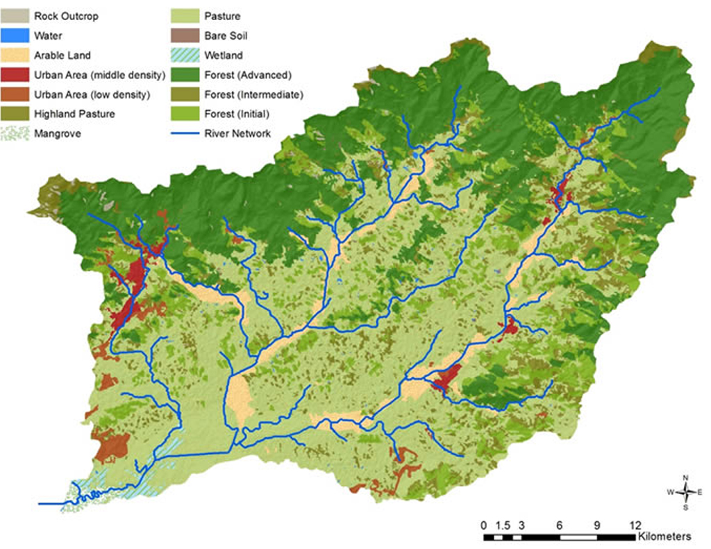
Currently, forest (in its different stages) and pasture are the dominant land uses within the GMRB (Cardoso Fidalgo et al., 2008). Together, they account for almost 90% of the total surface of the basin. Originally, the GMRB was covered by ombrophilous forest (Ecologus-Agrar, 2003) with high diversity of species – both flora and fauna – being the most important tree families, in descending order, Myrtaceae, Rubiacieae, Lauraceae, Arecaceae, Nyctaginaceae, Melastomataceae, among others (Wesenberg & Seele, 2009). The ombrophilous forest can be categorized, based on altitude, into: lowland (0-50 m), sub-montane (50-500 m), montane (500 – 1,500 m) and high-montane (>1,500 m) forest. The lowland and sub-montane forests have been degraded and, in some parts, disappeared due to human activities. Montane and high-montane forests present in the Serra dos Orgãos are relatively well conserved due to topography, lack of access and the implementation of natural protected areas (Ecologus-Agrar, 2003).
Pastures are used for extensive animal farming being cattle, swine, poultry and horses the most common elevated species (UFF/FEC, 2010). This land use occurs mainly in the lower parts of the basin as well as in low hills and half-oranges. Pastures tend to be degraded, eroded and sometimes abandoned due to urban emigration (Cardoso Fidalgo et al., 2008).
After forest and pasture agricultural land is the most important land use. Crop production accounts for almost 5% of the total surface of the GMRB. Nowadays, sugar cane and coffee no longer play an important role in the region. Crops such as banana, citrus, corn, yam, coconut, guava, scarlet eggplant and manioc have become the most cultivated crops in the region (UFF/FEC, 2010; Cardoso Fidalgo et al., 2008). The following table shows the cultivated area for each of the main crops and their estimated water requirements per year. Irrigation is not commonly practiced in the region and most of the hydric requirements for agriculture rely on precipitation. Only during summer some of the crops can undergo through hydric stress due to the lack of water.
Table: Surface and estimated water requirements of the most cultivated crops within the GMRB (EMATER, EMBRAPA)
| Crop | Cultivated Area [ha] |
Estimated Water Requirements [mm/yr1] |
| Banana | 1,250 | 1,200 |
| Manioc | 500 | 970 |
| Guava | 200 | 1,600 |
| Corn | 173 | 700 |
| Yam | 106 | 600 |
| Coconut | 100 | 2,200 |
| Citrus | 106 | 1,200 |
| Eggplant | 70 | 800 |
Forest is more common in the mountainous region along the Serra dos Orgãos (which can be seen in the back of the picture). Agriculture is practiced along the river margins as well in the lowland and small hills. In the picture a typical manioc field can be seen short before the harvest. Pastures, as in the picture, can be found abandoned on the lowlands or half-oranges.

As part of land use management several protected areas were created to avoid further deforestation and degradation of the environment within the GMRB. In the table below the most important protected areas are shown together with their surface, main vegetation and related rivers. The biggest protected areas are one in Macacu and the Três Picos Park with almost 25,000 ha surface each. There are also several protected areas to avoid deforestation and achieve a more sustainable land-use management within the basin.
Table: Protected areas and their respective area within the GMRB
| Protected Area | Surface [ha] | Main Vegetation | Main Rivers |
| APA de Guapimirim | 13,825 | Mangrove | Guapimirim |
| APA de Macacú | 24,500 | Alluvial tropical forest | Macacú and Guapiçu |
| Estação Ecológica do Paraíso |
5,000 | Mountainous tropical forest | Caboclo, Anil, Paraíso (tributaries of Guapiço river) |
| Parque Estadual Três Picos | 24,566 | Mountainous tropical forest | Macacú |
| Parque Estadual da Serra dos Órgãos | 4,730 | Mountainous tropical forest |
Roncador, Soberbo, Bananal (tributaries of Guapirim river) |
For instance, the APA in Guapirim is an important mangrove providing ecosystem services such as sediment fixation, pollution retention, breeding habitat and natural erosion barrier.
References and further reading:
Almeida, F. F. de M., Carneiro, C. dal R. (1998) Origem e Evoluçáo da Serra do Mar, Revista Brasileira de Geociências, 28(2), 135–150, http://sbgeo.org.br/pub_sbg/rbg/vol28_down/2802/2802135.pdf.
Barreiro, M., Chang, P., Saravanan, R. (2002) Variability of the South Atlantic Convergence Zone Simulated by an Atmospheric General Circulation Model, Journal of Climate, 15(7), 745–763, http://journals.ametsoc.org/doi/full/10.1175/1520-0442(2002)015<0745:VOTSAC>2.0.CO;2, accessed: 20.12.2013.
Benavides, Z. et al. (2009) Consumo e Abasticemento de Água nas Bacias Hidrográficas dos Rios Guapi-Macacu e Caceribu - RJ.
Ecologus-Agrar (2003) Plano Diretor de Recursos Hídricos da Região Hidrográfica da Baía de Guanabara, p. 3087.
Fernandes, N. F. et al. (2010) Rio de Janeiro: A Metropolis Between Granite-Gneiss Massifs, P. Migón, ed. Geomorphological Landscapes of the Worl, Springer, p. 387, http://books.google.com/books?id=-TI55urJYyEC&pgis=1, accessed: 21.12.2013.
Ferrari, A. L. (2001) Evolução Tectônica do Graben da Guanabara, Biblioteca Digital de Teses e Dissertações da USP, http://www.teses.usp.br/teses/disponiveis/44/44136/tde-29082013-152530/, accessed: 25.09.2013.
Fidalgo, E. C. et al. (2008) Uso e Cobertura da Terra na Bacia Hidrográfica do Rio Guapi-Macacu, Rio de Janeiro - Brazil.
Finotti, R. et al. (2012) Variations in structure, floristic composition and successional characteristics of forest fragments of the Guapiaçu river basin (Guapimirim/Cachoeiras de Macacu, RJ, Brazil). Acta Botanica Brasilica, 26(2), 464–475, http://www.scielo.br/scielo.php?script=sci_arttext&pid=S0102-33062012000200022&lng=en&nrm=iso&tlng=pt, accessed: 23.12.2013.
IUSS Working Group WRB (2006) World reference base for soil resources 2006, Rome.
Lumbreras, J. F. (2008) Relacoes solo-Paisagem no noroeste do estado do Rio de Janeiro: Subsídios ao Planejamento de uso sustentável em áreas de relevo acidentado do bioma Mata Atlântica, Universidade Federal de Rio de Janeiro.
Naegeli, F. E. (2010) Evaluation of Forest Fragmentation and Land Use Change Patterns using Remote Sensing Techniques and Field Methods.
Penedo, S. et al. (2011) Implementation of a Hydro-climatic Monitoring Network in the Guapi-Macacu River Basin in Rio de Janeiro Brazil, XIVth IWRA World Water Congress, Porto de Galinhas, Brazil, p. 12, http://dinario.fh-koeln.de/pdf/Implementation of a Hydro-climatic Monitoring Network in the Guapi-Macacu River Basin in Rio de Janeiro Brazil.pdf.
Pinheiro, H. S. K. et al. (2012) Modelos de elevação para obtenção de atributos topográficos utilizados em mapeamento digital de solos, Pesquisa Agropecuária Brasileira (Online), 47, p.10, http://geostat-course.org/node/1033, accessed: 23.09.2013.
Riccomini, C., Sant’Anna, L. G., Ferrari, A. L. (2004) Evolução geológica do Rift Continental do sudeste do Brasil, V. Mantesso-Neto et al., eds. Geologia do Continente Sul-Americano: Evoluçao da obra de Fernando Flávio Marques de Almeida, Beca, 383–405.
Scheffer, F. et al. (2009) Lehrbuch der Bodenkunde (Sav Geowissenschaften) (German Edition), Spektrum Akademischer Verlag, http://www.amazon.com/Lehrbuch-Bodenkunde-Geowissenschaften-German-Edition/dp/3827413249, accessed: 30.09.2013.
UFF/FEC (2010) Planejamento Estratégico da Região Hidrográfica dos Rios Guapi-Macacu e Caceribu-Macacu, Niterói, Brazil.
Wesenberg, J., Seele, C. (2009) Floristic-structural composition and diversity of tree and woody understorey vegetation in the montane Atlantic Forest of the Serra dos Órgaos National Park, Teresopolis, RJ, Brazil, H. Gaese et al., eds. Biodiversity and land use systems in the fragmented Mata Atlântica of Rio de Janeiro, Göttingen, p. 46, http://dinario.fh-koeln.de/pdf/Chapter 14_Wesenberg & Seele_259-280.pdf.