Paute River Basin (Ecuador)
Climate
The climate in the Paute River Basin varies according to region. This variation includes cold equatorial weather in the high-altitude mountains, cold weather in the páramos, temperate and subtropical weather in the valley and fully tropical weather in the lower level plains.
The climate in the region is mainly influenced by the continental air masses from the Amazon and to a lesser degree by the masses from the Pacific Ocean (Vuille et al., 2000). The wet air masses from the Amazonian valleys cause rainfall throughout the year, mainly influencing the eastern part of the basin and air masses from the Pacific Ocean reach the western edge of the basin influencing this area. Additionally, the region is affected by the Inter Tropical Convergence Zone (ITCZ) fluctuations, the El Niño Southern Oscillation (ENSO) and in a few cases by dry cool air masses from the west (Humboldt current influence) (Bendix et al. 2006).
Precipitation in the Paute River Basin is also strongly variable. There are two rainfall regimes, unimodal (UM) and bimodal (BM) shown in Figure 2. As illustrated by Célleri et al. (2007), the unimodal regime has a rain peak in June or July, whereas the bimodal regime has rain peaks in both April and October. Each regime can be further subdivided due to large differences in annual rainfall. The bimodal regime covers the higher part and the unimodal regime covers the lower part of the basin. Orography and the western cordillera slopes influence the precipitation patterns (Campozano et al., 2016). Mean annual rainfall within the basin ranges from 660 mm to 3400 mm.
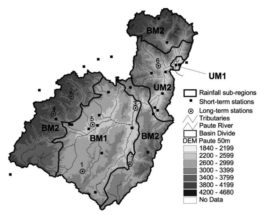
Figure 2: Rainfall subregions: UM1, Unimodal 1; UM2, Unimodal 2; BM1, Bimodal 1; BM2, Bimodal 2. (Source: Célleri et al. 2007)
Local meteorological factors are influenced by topography and relief, producing precipitation gradients according to altitude, slopes and prevailing winds. In this way, there is a precipitation zone that increases with altitude, while in a second zone, precipitation decreases with altitude. This is shown Figure 3.
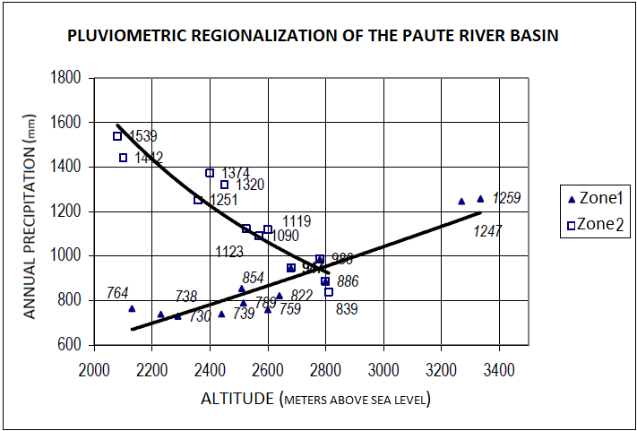
Figure 3: Precipitation altitudinal patterns
(Source: CG Paute, 2008. The values shown are averages registered from 1964 to 1989.)
References and further reading:
Bendix, J., Rollenbeck, R., Göttlicher, D., and Cermak, J. (2006). Cloud occurrence and cloud properties in Ecuador. Clim. Res. 30, 133–147.
Buytaert, W., De Bièvre, B., Wyseure, G., and Deckers, J. (2004). The use of the linear reservoir concept to quantify the impact of changes in land use on the hydrology of catchments in the Andes. Hydrol. Earth Syst. Sci. 8, 108–114.
Buytaert, W., Célleri, R., De Bièvre, B., Cisneros, F., Wyseure, G., Deckers, J., Hofstede, R. (2006). Human impact on the hydrology of the Andean páramos
Earth-Science Reviews, 79 (1-2), pp. 53-72. doi: 10.1016/j.earscirev.2006.06.002.
Buytaert, W., and De Bièvre, B. (2012). Water for cities: The impact of climate change and demographic growth in the tropical Andes. Water Resources Research, 48, W08503. https://doi.org/10.1029/2011WR011755.
Campozano, L., Célleri, Ro., Trachte, K., Bendix, J., and Samaniego, E. (2016). Rainfall and Cloud Dynamics in the Andes: A Southern Ecuador Case Study. Advances in Meteorology. https://doi.org/10.1155/2016/3192765.
Célleri, R., Willems, P., Buytaert, W., and Feyen, J. (2007). Space–time rainfall variability in the Paute basin, Ecuadorian Andes. Hydrological Processes, 21, 3316–3327. https://doi.org/10.1002/hyp.6575.
Célleri, R., and Feyen, J. (2009). The hydrology of tropical Andean ecosystems: Importance, knowledge status, and perspectives. Mt. Res. Dev. 29, 350–355, doi:10.1659/mrd.00007.
Célleri, R., Buytaert, W., De Bièvre, B., Tobón, C., Crespo, P., Molina, J., and Feyen, J. (2010). Understanding the hydrology of tropical Andean ecosystems through an Andean Network of Basins. IAHS-AISH, 336, 209–212. https://doi.org/10.13140/2.1.4187.3608.
Coltorti, M., and Ollier, C.D. (2000). Geomorphic and tectonic evolution of the Ecuadorian Andes. Geomorphology 32, 1-19.
Consejo de Gestión de Aguas de la Cuenca del Paute, CG Paute (2008). Plan maestro de la Cuenca del Río Paute.
Hall, M.L., and Beate, B. (1991). El vulcanismo Plio-Quaternario en los Andes del Ecuador. El paisaje Volcanico de la Sierra Ecuatoriana. Estudios Geograficos, vol. 4, pp. 5–17
Instituto Nacional de Estadística y Cencos, INEC (2001). VI Censo de Población y V de Vivienda 2001, Resultados Definitivos, Resumen Nacional.
Instituto Nacional de Estadística y Cencos, INEC (2007). Proyecciones de la Población Ecuatoriana por Áreas y Años Calendario, según Provincias y Cantones Período 2001-2010.
Intergovernmental Panel on Climate Change, IPCC (2013). The Physical Science Basis.
Noblet, C., Lavenu, A., and Schneider, F. (1988). Etude géodynamique s'un bassin intramontagneux tertiaire sur décrochements dans les Andes du sud de l'Equateur: l'example du bassin de Cuenca. Géodynamique 3, 117–138.
Sierra, R. (1999). Propuesta preliminar de un sistema de clasificación de vegetación para el Ecuador continental. Proyecto INEFAN/GEF-BIRF y EcoCiencia. Quito, Ecuador.
Unidad de Manejo para la Cuenca del Río Paute, UMACPA (1995). Estudios Geomorfológico de la Dinámica de los Principales Procesos Erosivos y de Sedimentación de la Cuenca del Río Paute. Cuenca-Ecuador.
Vanacker, V., Molina, A., Govers, G., Poesen, J., and Deckers, J. (2007). Spatial variation of suspended sediment concentrations in a tropical Andean river system: The Paute River, southern Ecuador. Geomorphology 87, 53-67.
Vuille, M., Bradley, R.S., and Keimig, F. (2000). Climate variability in the andes of Ecuador and its relation to tropical Pacific and Atlantic sea surface temperature anomalies. J. Clim. 13, 2520–2535.