LAM PA CHI RIVER BASIN (THAILAND)
Natural Environment
The basin is located entirely within the territory of Thailand and is a sub-basin of the Mae Nam Mae Klong River Basin. Naturally, the basin is bordering the Mae Nam Phetchaburi River Basin in the South, the Mae Nam Tha Chin in the East and small catchments in the Tanintharyi Region, Myanmar in the West. It has a drainage area of 2,550 km² (representing approximately 8% of the Mae Klong) ranging from 99° 9' 54.0'' – 99° 35' 31.2'' E and 13° 8' 52.8'' – 13° 56' 20.4'' N. The terrain in the basin is characterized by high mountains and steep river valleys. The elevation varies from 36 m.a.s.l. at the outlet until 1,156 m.a.s.l. at the mountain range bordering with Myanmar (see Figure). The major stream runs north and joins the Tha Khoei river at the outlet of the sub-basin.

Geology
According to Maita et al. (2004) igneous rocks from the Mesozoic and sedimentary rocks from the Paleozoic underlie the headwaters and the mountain range bordering Myanmar. Downstream, the lowlands of the watershed are formed from sedimentary rocks from the Quaternary Period. Geologically, Lam Pa Chi is formed with rock ranging in ages from Cambrian to Quaternary periods:

Quaternary sediments in the Lam Pa Chi are subdivided into two sub-groups. The fluvial terraces, with coarse-grained sedimentary rock are distributed along the Pa Chi River in the middle and lower parts. The terrace deposits with gravel, silt, clay are formed in large areas in the lower part. Cretaceous sediments forming on the in the granite, biotite - muscovite granite with gray and orphyritic texture occurred in the areas, along the Thailand-Myanmar border and in the southeastern parts. The rock formed in this period ranks the second largest area (751 km2), after Carboniferous periods (897 km2). Rocks formed during Jurassic and Triassic periods are characterized by red-brown conglomerate mixed with shale and mudstone. The rocks in this period exist in small areas (30 km2) along the fault in the northeast. A small area (5 km2) of sandstone, limestone, shale, siltstone and sandstone with volcanic texture were formed during Permian period. Rocks with Carboniferous ages are subdivided into three sub-groups: quartzite, slate, shale, hornfels, schist -like grains in a preferred orientation (Chp); mudstone, sandstone composed of rock grans, brown shale with fossil (Ckp); and sandstone and white quartzitic sandstone, shale with volcanic ash, shale with silica content (Ckw). They are distributed in the northwestern parts. Quartzite, quart schist, phyllite, phyllite with charcoal texture formed in Silurian - Devonian periods are distributed in a strip (191 km2) from northwest to southeast between rocks dating Cretaceous and Carboniferous periods. High-degree-induration quartzite, slate in Cambriam-Ordovician period and limestone, gray- or dark gray-micrite in Ordovician period distribute in small areas. Total areas of these rocks are 11 km2.
The following figure shows the different soils in the basin:

Land Use
Land use changes (e.g. deforestation, agricultural expansion, urbanization) can be regarded as important driving forces enhancing the current hydrological and water quality degradation trend in the world. Changes in land cover and in land use have become recognized over the last decades as important global environmental changes (Turner II, 2002). Land use changes are also interrelated with other important environmental issues, such as climate change and carbon cycle, loss of biodiversity, and sustainability of agriculture (Lepers et al., 2005)

The region has faced rapid land use changes in the last decades including deforestation processes to gain the land for agricultural production. The impacts of deforestation on water resources are well documented including soil erosion, flooding, biodiversity and impairment of water quality through sediments (Foley et al., 2005), among others. Based on data from the Royal Forest Department (RFD) from 2002 Thangtham (2002) found out that in the provinces of Ratchaburi and Kanchanaburi (main provinces for the Lam Pa Chi) the forest cover drastically decreased during the period 1961-2000 going from 64.8% to 25.1% and from 91.3% to 60.5%, respectively. Forest clearance has the main purpose of increasing the area for crop production.
The different types of forest (including evergreen, deciduous and mixed) and field crops account for almost 85% of the total surface of the basin. Forest land use is found mainly in the mountain range in the western and southern part of the catchment. Moreover, crops are mainly produced in the lower and flatter parts such as the floodplains as well as in the hilly areas, in the case of pineapple.
The areal distribution of land cover is shown in the following table:
Table: Land use classes and their respective area within the LPCRB
| Land use types |
Area (km2) |
| Deciduous forest | 1,116.6 (44.1%) |
| Evergreen forest | 187.0 (7.4%) |
| Mixed forest | 3.9 (0.2%) |
| Grassland | 80.7 (3.2%) |
| Paddy field | 47.6 (1.9%) |
| Annual crops | 917.5 (36.2%) |
| Perennial trees | 136.2 (5.4%) |
| Urban | 37.6 (1.5%) |
| Water body | 6.4 (0.3%) |
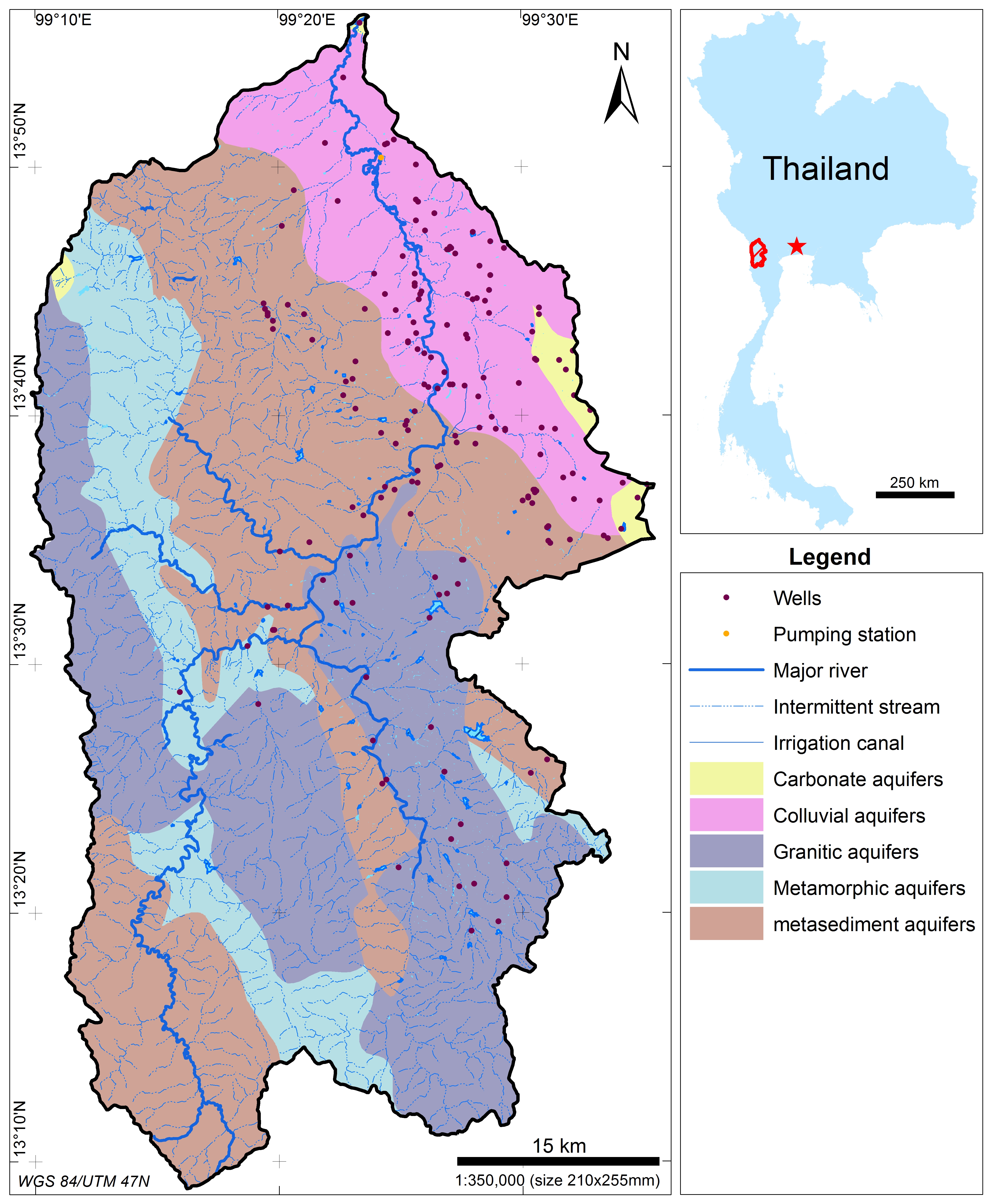
GROUNDWATER AQUIFERS
Table: Aquifers in the basin
| Name |
Age |
Area (km2) |
| Metamorphic aquifer | Cambrian to Devonian | 133.9 |
| Granitic aquifers | Cretaceous | 810.2 |
| Carbonate aquifer | Ordovician | 3.7 |
| Carbonate aquifer | Permian | 28.7 |
| Metasediment aquifer | Permian to Carboniferous | 978.6 |
| Metamorphic aquifer | unknown | 233.8 |
| Colluvial aquifer | upper Tertiary to Quaternary | 384.3 |
Aquifers in the basin were dated from Cambrian to Quaternary periods. The Metasediment aquifers in Permian to Carboniferous periods share the largest areas and the aquifers formed in Ordovician period are smallest. The granitic aquifers and colluvial aquifers have good quality while the water quality of Carbonate aquifers is moderate and the water quality of metamorphic aquifers is suitable for domestic use (Department of Water Resources, Thai MONRE).
The main channel is 130 km long and it has its headwaters in the western and southern mountain range draining the basin in a South-North orientation before meeting the Thai Khoei river. Streamflow responds accordingly to the precipitation pattern showing two main seasons: a wet and a dry season. According to monthly data available at the most downstream discharge station (k.62) the highest discharge occurs in October with an average value of 56 m³/s while the driest months are from January until March with less than 3 m³/s of streamflow in average. The ratio between the highest and the lowest streamflow is 25:1 showing a high intra-annual variability. Furthermore, two of the most relevant environmental problems in the basins are related with the response of the streamflow during the two abovementioned seasons: (i) flooding during the wet season and (ii) water scarcity during the dry period.
References and further reading:
Chanket, U., Mongkolsawat, C. (2009) An analysis of multi-temporal satellite data for land cover change and its impact on soil erosion over the upper namphong watershed, Northeast Thailand. 30th Asian Conference on Remote Sensing 2009, ACRS 2009, Beijing.
Henderson, G. S., Rouysungnern, S. (1985) Erosion and sedimentation in Thailand." Symposium on effects of forest land use on erosion and slope stability, 1984, Honolulu: 31-39.
Ishikawa, R. et al. (2006) Genetic erosion from modern varieties into traditional upland rice cultivars (Oryza sativa L.) in Northern Thailand, Genetic Resources and Crop Evolution 53(2): 245-252.
Jantawat, S. (1985) An overview of soil erosion and sedimentation in Thailand, Soil erosion and conservation: 10-14.
Krishna Bahadur, K. C. (2009) Mapping soil erosion susceptibility using remote sensing and GIS: A case of the Upper Nam Wa Watershed, Nan Province, Thailand, Environmental Geology 57(3): 695-705.
Lal, R. (2001) Soil degradation by erosion, Land Degradation and Development 12(6): 519-539.
LDD (2000) Soil Erosion in Thailand. Land Development Department, Ministry of Agriculture and cooperatives.
Meier, G., Zumbroich, T., Roehrig, J. (2013) Hydromorphological assessment as a tool for river basin management: The German field survey method, Journal of Natural Resources and Development 3: 14-26.
Morgan, R. P. C. (2009) Soil Erosion and Conservation, Wiley.
Morgan, R. P. C., Morgan, D. D. V., Finney, H. J. (1984) A predictive model for the assessment of soil erosion risk, Journal of Agricultural Engineering Research 30(C): 245-253.
Nontananandh , S., Changnoi, B. (2012) Internet GIS, based on USLE modeling, for assessment of soil erosion in Songkhram watershed, Northeastern of Thailand, Kasetsart Journal - Natural Science 46(2): 272-282.
Paiboonsak, S., Chanket, U., Mongkolsawat, C., Yommaraka, B., Wattanakit, N. (2005) Spatial modeling for soil erosion risk in upper Chi basin, Northeast Thailand, 26th Asian Conference on Remote Sensing, ACRS 2005 and 2nd Asian Space Conference, ASC, Ha Noi.
Paiboonvorachat, C., Oyana, T. J. (2011) Land-cover changes and potential impacts on soil erosion in the nan watershed, Thailand, International Journal of Remote Sensing 32(21): 6587-6609.
Pensuk, A., Shrestha, R. P. (2010) GIS application for assessing the effects of land use change on surface runoff and soil erosion in phatthalung watershed, Southern Thailand, 31st Asian Conference on Remote Sensing 2010, ACRS 2010, Hanoi.
Plangoen, P., Babel, M. S., Clemente, R. S., Shrestha, S., Tripathi, N. K. (2013) Simulating the impact of future land use and climate change on soil erosion and deposition in the Mae Nam Nan sub-catchment, Thailand, Sustainability (Switzerland) 5(8): 3244-3274.
Renard, K. G., Foster, G. A., Weesies, G. A., McCool, D. K., Yoder, D. C. (1997) Predicting Soil Erosion by Water: A Guide to Conservation Planning with the Revised Universal Soil Loss Equation (RUSLE), USDA Agriculture Handbook, Agricultural Research Service (USDA) 703: 404 pp.
Sang-Arun, J., Mihara, M., Horaguchi, Y., Yamaji, E. (2006) Soil erosion and participatory remediation strategy for bench terraces in northern Thailand, Catena 65(3): 258-264.
Shrestha, D. P., Suriyaprasit, M., Prachansri, S. (2014) Assessing soil erosion in inaccessible mountainous areas in the tropics: The use of land cover and topographic parameters in a case study in Thailand, Catena 121: 40-52.
Sriboonlue, V., Trelo-Ges, V., Pilawut, S., Khetkratok, N. (2004) Crop furrow erosion assessment in field crop plots in northeast Thailand, Transactions of the American Society of Agricultural Engineers 47(2): 419-425.
Sthiannopkao, S., Takizawa, S., Homewong, J., Wirojanagud, W. (2007) Soil erosion and its impacts on water treatment in the northeastern provinces of Thailand, Environment International 33(5): 706-711.
Turkelboom, F., Poesen, J., Ohler, I., Ongprasert, S. (1999) Reassessment of tillage erosion rates by manual tillage on steep slopes in northern Thailand, Soil and Tillage Research 51(3-4): 245-259.
Turkelboom, F., Poesen, J., Ohler, I., Van Keer, K., Ongprasert, S., Vlassak, K. (1997) Assessment of tillage erosion rates on steep slopes in northern Thailand Catena 29(1): 29-44.
Turkelboom, F., Poesen, J., Trébuil, G. (2008) The multiple land degradation effects caused by land-use intensification in tropical steeplands: A catchment study from northern Thailand, Catena 75(1): 102-116.
Weterings, R. (2011) A GIS-based assessment of threats to the natural environment on Koh Tao, Thailand, Kasetsart Journal - Natural Science 45(4): 743-755.
Wijitkosum, S. (2012) Impacts of land use changes on soil erosion in Pa Deng sub-district, adjacent area of Kaeng Krachan National Park, Thailand, Soil and Water Research 7(1): 10-17.
Wischmeier, W. H., Smith, D. D. (1978) Predicting Rainfall Erosion Losses - A Guide to Conservation Planning, 1st ed, Agriculture Handbook, ARS & USDA: 69 pp.
Ziegler, A. D., Giambelluca, T. W. (1997) Simulation of runoff and erosion on mountainous roads in northern Thailand: A first look, Proceedings of the 1997 5th Scientific Assembly of the International Association of Hydrological Sciences, IAHS, Wallingford, United Kingdom Rabat, Morocco, IAHS Press.
Ziegler, A. D., Giambelluca, T. W., Sutherland, R. A. (2001) Erosion prediction on unpaved mountain roads in northern Thailand: Validation of dynamic erodibility modelling using KINEROS2, Hydrological Processes 15(3): 337-358.
Ziegler, A. D., Giambelluca, T. W., Sutherland, R. A. (2001) Acceleration of Horton overland flow and erosion by footpaths in an upland agricultural watershed in northern Thailand, Geomorphology 41(4): 249-262.