Tinto, Odiel and Piedras (Spain)
Hydrology
The Tinto, Odiel y Piedras watershed is formed by three main catchments:
- The Odiel river, with an annual average flow of 11,4 m3/s, which main tributaries are the Olivargas, Oranque and Meca river;
- The Tinto river, of 6,2 m3/s, which flows into the Odiel river a few kilometres upstream its mouth, and
- The Piedras river, which flows towards the Atlantic ocean in the Gulf of Cadiz, with an annual flow of 0,7 m3/s
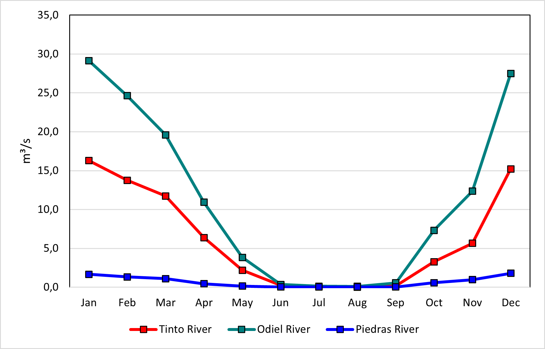
Figure 1: Monthly average flows of 3 main rivers of DHTOP (1940-2017)
Groundwater resources
In the TOP, there are 4 groundwater bodies. These aquifers cover an area of 1 510 km², which represent approximately 32% of the continental portion of the basin. The average total annual infiltration is estimated at 26 mm/year. Maximum recharge occurs during the winter months, while June, July, and August exhibit the lowest infiltration (Junta de Andalucía, 2023).
Water Quality
A key factor influencing water quality in the TOP is the presence of the Iberian Pyrite Belt (IPB) in the upper catchment of the Tinto and Odiel river basins. The Odiel River receives its first acidic inflows from the discharge of the Concepción, San Platón, Esperanza, and Poderosa mines, but its water quality deteriorates significantly when it receives water from the Agrio Stream that transports sulfates, aluminum, zinc, among others, from the mines of Riotinto (Bonnail et al., 2015). This river is considered an extreme case of global contamination, transporting exceptionally high concentrations of dissolved pollutants, including 9,138 tons per year of aluminum (Al) and 2,764 tons per year of zinc (Zn), among others (Galván & Olías, 2015).
The Tinto River receives acid lixivates from the mining district of Riotinto, in the headwaters of the catchment, where pH reaches values as low as 2.0.
References:
Bonnail, E., Sarmiento, A. M., Nieto, J.-M., & Delvalls, T. Á. (2015). Caracterización del Riesgo Ecológico Asociado a Metales en Sedimentos de la Cuenca del Río Odiel a Través de Índices Teóricos.
Galván, L., & Olías, M. (2015). Estudio de la Contaminación por Drenaje Ácido de Minas en la Cuenca del Río Odiel.
Junta de Andalucía. (2023). Plan Hidrológico Revisión de tercer ciclo (2022-2027) Anejo II: Inventario de recursos hídricos.