Tinto, Odiel and Piedras Basin (Spain)
Natural Environment
The Tinto, Odiel and Piedras basin is located in Andalucia, southwestern Spain and occupies the central-southern sector of Huelva province, between the Guadiana and Chanza rivers to the west and north and the mountain front of the Sierra de Aracena to the east, extending southwards to the Atlantic coastline in the Gulf of Cádiz.
The catchment system covers 4.762 km² of which 98% corresponds to the province of Huelva and 2% to the province of Seville (Junta de Andalucía, 2022).
Geomorphology
The Tinto, Odiel and Piedras catchments extend from the softly contoured northern uplands of the Sierra de Huelva to the flat Atlantic coastal plains (Moreno et al., 2008). Only a small sector of the Sierra lies within the basin, forming the headwaters of the Odiel and Tinto rivers (Junta de Andalucía, 2022). Here, rounded ridges and narrow valleys host chestnut and pine forests at higher elevations, while lower and mid-slope positions show mosaics of Dehesa, abandoned eucalyptus stands and degraded shrubland shaped by grazing and recurrent fires (Domingo-Santos & Corral-Pazos de Provens, 2025). This abrupt transition from hilly relief to rolling piedmont sets up the basin’s characteristic north–south gradient (Moreno et al., 2008). Southward, the landscape opens into the Andévalo, a broad hilly zone dominated by these Dehesa landscapes, combining open woodland, shrubland and pasture (Moreno et al., 2008). This unit forms the morphological bridge between the uplands and the more dissected central belt. Further downstream, the Cuenca Minera presents a more dissected relief structured by a dense drainage network (Moreno et al., 2008) and shaped by a long history of mining activity in the Iberian Pyrite Belt (Cáceres et al., 2023). Toward the lower basin, the Condado forms gently undulating terraces and plains that gradually merge with the Costa, where sandy deposits, dunes and coastal marshes such as the Marismas del Odiel define the Atlantic fringe and the outlet of the basin. These coastal formations mark the final flattening of the basin and illustrate the progressive smoothing of relief toward the Atlantic (Moreno et al., 2008).
Geology
The geological organisation of the Tinto, Odiel and Piedras (TOP) basin mirrors the arrangement of Huelva’s major land cover types (Moreno et al., 2008). At the northern margin, a narrow fringe of the Ossa-Morena Zone enters the basin, composed of Precambrian to Palaeozoic schists, greywackes, black quartzites, slates and interbedded amphibolite’s and volcanic rocks, all strongly deformed and cut by major fracture and shear zones including the Aracena Metamorphic Belt (Fernández Rodríguez & Díaz Azpiroz, 2008). These ancient metamorphic and igneous rocks form the structural core of the northern uplands (Fernández Rodríguez & Díaz Azpiroz, 2008). South of this boundary, the succession shifts into the South Portuguese Zone, which dominates almost the entire basin and represents one of the most distinctive geological provinces in Europe (Donaire et al., 2008). Its Middle Devonian to Permian volcano-sedimentary formations host the Iberian Pyrite Belt, internationally recognised as the region with the greatest concentration of massive sulphide deposits in the world (Donaire et al., 2008), a volcanic-hosted massive sulphide province formed by submarine hydrothermal activity (Nieto et al., 2013). The exposure of these sulphide-rich units underpins a mining history stretching back approximately 4,500 years, from Chalcolithic copper extraction and intensive Roman silver and copper operations to industrial-scale sulphide mining from the mid-nineteenth century onward (Olías & Nieto, 2015). Weathering of these sulphide-rich materials generates acid mine drainage that affects not only the Tinto and Odiel but also their tributaries and associated streams, producing highly acidic and metal-rich waters throughout the basin (Nieto et al., 2013). Further south, the Paleozoic basement is overlain by Neogene and Quaternary marls, sands and alluvial deposits of the Guadalquivir Basin (Mayoral Alfaro & Abad, 2008). Toward the Atlantic margin, these Neogene–Quaternary units are in turn covered by unconsolidated coastal, estuarine and aeolian sediments that form dune systems, sandy littoral deposits and the estuarine complex of the Ría de Huelva (Morales & Borrego Flores, 2008). Along this transect, the exposed rocks also show a marked age gradient, with the oldest materials in the north and progressively younger formations toward the coast (Moreno et al., 2008).
Soils
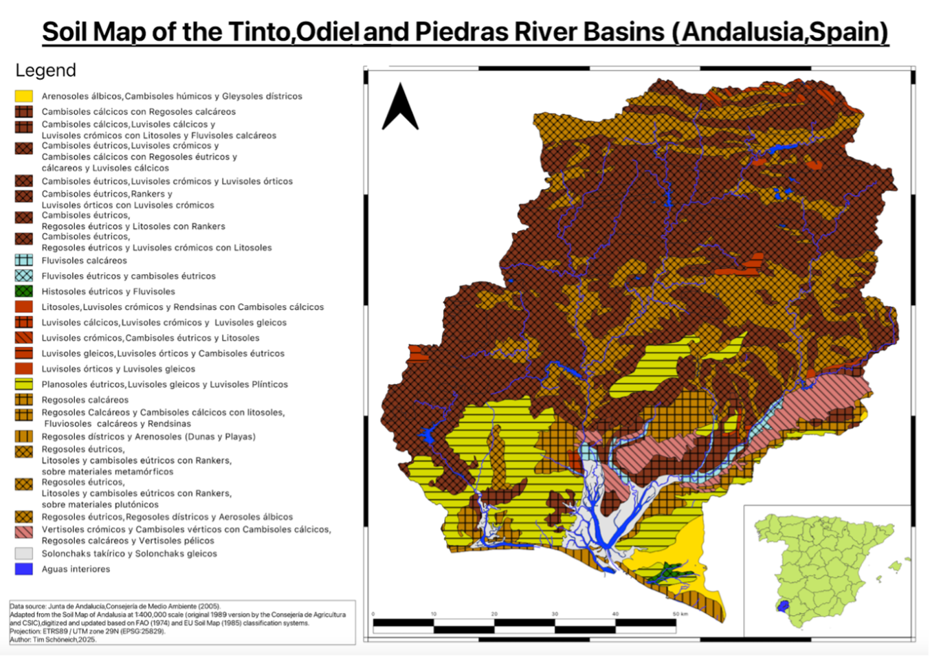
Figure 2 shows the major soil types in the TOP basin using the EU/FAO soil map classification system and data of the Environmental Department of the Government of Andalusia. The soil classes correspond to the basin’s geological and topographical features. Across the northern uplands and the Andévalo plateau, Palaeozoic schists, greywackes and quartzites give rise predominantly to shallow, stony Cambisols and Leptosols (Olías & Galván, 2008), with Regosols on convex upper slopes (Domingo-Santos & Corral Pazos de Provens, 2025). These profiles are commonly less than 50 cm deep, low in organic matter and fine earth, and carry a low available water capacity that leaves the herbaceous layer particularly vulnerable to drought during the long, hot summers (Schnabel et al., 2013). The siliceous parent material drives a predominantly acidic soil reaction throughout this zone, with low cation exchange capacity, limited available phosphorus, and an inherent susceptibility to surface erosion (Domingo-Santos & Corral Pazos de Provens, 2025). Luvisols are largely confined to lower concave positions where clay accumulation improves profile development and water retention. In closed and current mining regions,, the soils developed on tailings and residues are severely acidified and metal-contaminated (Fernández Caliani & Barba Brioso, 2008), effectively preventing natural revegetation (Olías & Galván, 2008). Southward, the Neogene and Quaternary deposits of the Condado support a distinctly different pedological environment: Vertisols, abundant between Niebla and La Palma, develop on clayey and marly substrates, while Calcisols occur where calcareous facies prevail (Olías & Galván, 2008). Toward the coast, deep sandy Arenosols dominate, and Fluvisols occupy the terraces and back swamps of the lower river courses, with localised salinity near the estuaries (Domingo-Santos & Corral Pazos de Provens, 2025).
The Tree-Livestock-Soil System of the Dehesas
Despite the inherent pedological limitations of the northern and central basin, the Dehesa system maintains a self-sustaining mechanism that substantially compensates for low soil fertility. Trees act as “ecosystem engineers” (Moreno & Pulido, 2009): their deep root systems access nutrients and water from depth, returning them to the surface soil via litterfall, root decay and canopy leaching. Although trees typically occupy only around 20% of the ground surface (Moreno & Pulido, 2009), they account for more than half of annual nutrient inputs to the system, delivering substantial quantities of nitrogen, phosphorus and potassium beneath their canopies and roughly doubling net nitrogen mineralisation relative to open intercanopy patches (Gallardo et al., 2000). This process creates a pronounced spatial heterogeneity in soil organic carbon and nutrient availability, with enriched “islands of fertility” beneath canopies extending up to 8 m from the trunk (Simón et al., 2013), in sharp contrast to the comparatively nutrient-poor open pasture. Livestock completes this feedback loop: grazing animals concentrate under tree shade, redistributing nutrients across the landscape via dung deposition (Joffre et al., 1999) and accelerating organic carbon turnover in upper soil horizons (Simón et al., 2013). The functional integrity of Dehesa landscapes in the TOP basin therefore rests on the continuous interaction between tree canopy, soil, and livestock (Moreno & Pulido, 2009), which together sustain nutrient cycling and ecological stability under conditions where the soils alone, given their limited fertility, would be insufficient to support productive land use (Pulido-Fernández et al., 2013).
Landuse
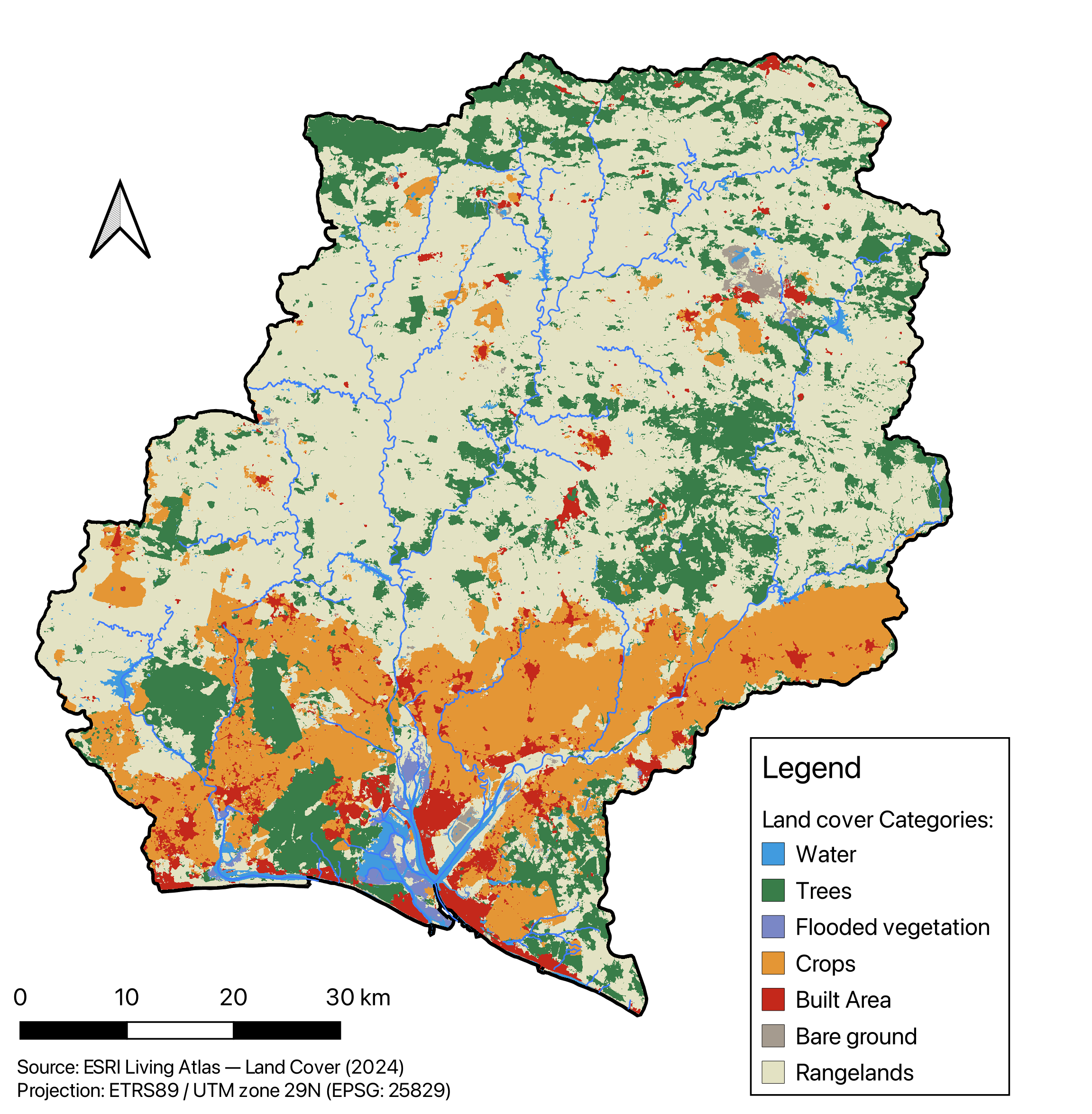
Figure 3 shows a rough land cover map indicating the major cropland areas (orange), forests and rangeland.
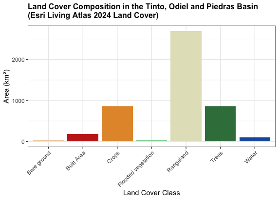
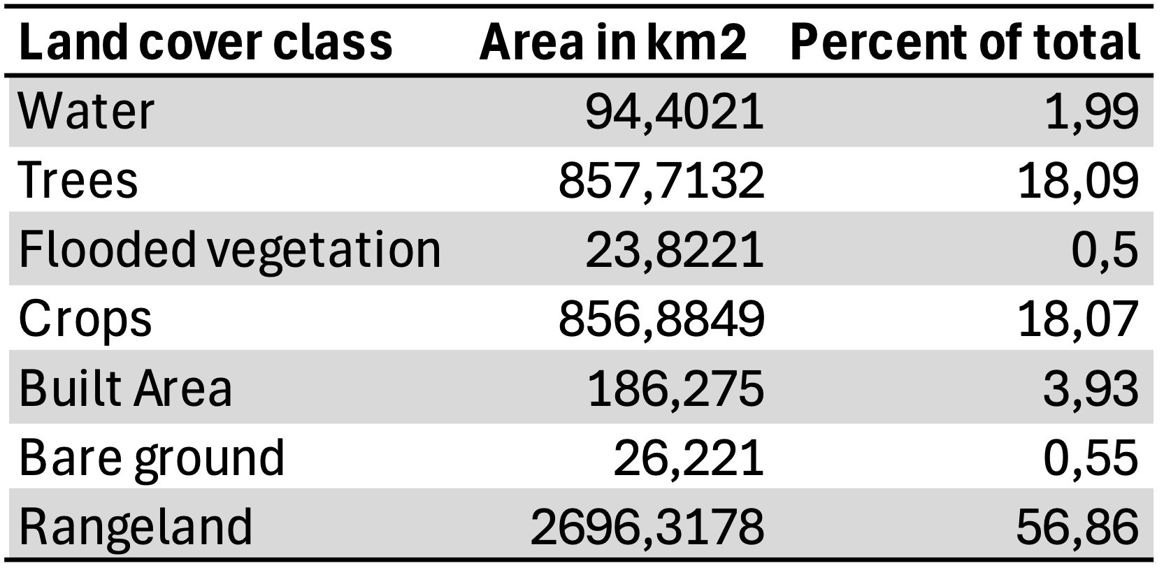
Rangelands – consisting of shrubland and Dehesas (?) - are the dominant land cover class in the TOP basin, accounting for 56.9% of the basin surface (approximately 2 696 km²), and are concentrated across the northern and central Andévalo plateau, where the open woodland-pasture systems known as dehesa are characteristic (ESRI Living Atlas, 2024). Tree cover and cropland each account for approximately 18% of the basin, with the latter predominantly found in the southern lowlands and coastal zone, reflecting the intensive berry and strawberry cultivation that has expanded significantly in recent decades. Built-up areas cover 3.9% of the basin (186 km²), concentrated around the provincial capital of Huelva and the adjacent Polo Químico industrial corridor. Flooded vegetation (0.5%) and open water (2.0%) together delineate the wetland and reservoir systems of the basin, including the internationally protected marshes at the river mouths. Bare ground, with 0.6%, is largely attributable to active and legacy mining areas associated with the Iberian Pyrite Belt.
References:
Cáceres, L. M., Ruiz, F., Bermejo, J., Fernández, L., González-Regalado, M. L., Rodríguez-Vidal, J., Abad, M., Izquierdo, T., Toscano, A., Gómez, P., & Romero, V. (2023). Sediments as sentinels of pollution episodes in the middle estuary of the Tinto River (SW Spain). Soil Systems, 7(4), 95. https://doi.org/10.3390/soilsystems7040095
Domingo-Santos, J. M., & Corral Pazos de Provens, E. (2025). Suelos forestales de la provincia de Huelva: Propiedades, evolución y distribución territorial. Huelva: Editorial Universidad de Huelva.
Fernández Caliani, J. C., & Barba Brioso, C. (2008). Suelos contaminados por actividades mineras. In Facultad de Ciencias Experimentales (Ed.), Geología de Huelva: Lugares de interés geológico (pp. 87–88). Huelva: Universidad de Huelva.
Junta de Andalucía. (2022). Plan Hidrológico 2022–2027. Demarcación Hidrográfica del Tinto, Odiel y Piedras: Memoria. Sevilla: Junta de Andalucía.
Nieto, J. M., Sarmiento, A. M., Cánovas, C. R., Olías, M., & Ayora, C. (2013). Acid mine drainage in the Iberian Pyrite Belt: 1. Hydrochemical characteristics and pollutant load of the Tinto and Odiel rivers. Environmental Science and Pollution Research, 20, 7509–7519. https://doi.org/10.1007/s11356-013-1634-9
Olías, M., & Galván, L. (2008). Los suelos. In Facultad de Ciencias Experimentales (Ed.), Geología de Huelva: Lugares de interés geológico (pp. 50–52). Huelva: Universidad de Huelva.
Joffre, R., Rambal, S., & Ratte, J.-P. (1999). The dehesa system of southern Spain and Portugal as a natural ecosystem mimic. Agroforestry Systems, 45(1–3), 57–79.
Moreno, C., González, F., & Sáez, R. (2008). La provincia de Huelva desde una perspectiva geológica. In Facultad de Ciencias Experimentales (Ed.), Geología de Huelva: Lugares de interés geológico (pp. 5–7). Huelva: Universidad de Huelva.
Fernández Rodríguez, C., & Díaz Azpiroz, M. (2008). Geología de la zona de Ossa-Morena. In Facultad de Ciencias Experimentales (Ed.), Geología de Huelva: Lugares de interés geológico (pp. 8–13). Huelva: Universidad de Huelva.
Donaire, T., Pascual, E., Rodríguez Vidal, J., González, F., Moreno, C., & Sáez, R. (2008). Geología de la zona Surportuguesa (Andévalo). In Facultad de Ciencias Experimentales (Ed.), Geología de Huelva: Lugares de interés geológico (pp. 14–19). Huelva: Universidad de Huelva.
Mayoral Alfaro, E., & Abad, M. (2008). Geología de la Cuenca del Guadalquivir. In Facultad de Ciencias Experimentales (Ed.), Geología de Huelva: Lugares de interés geológico (pp. 20–27). Huelva: Universidad de Huelva.
Morales, J. A., & Borrego Flores, J. (2008). El litoral de Huelva: fisiografía y dinámica. In Facultad de Ciencias Experimentales (Ed.), Geología de Huelva: Lugares de interés geológico (pp. 28–36). Huelva: Universidad de Huelva.
Olías, M., & Nieto, J. M. (2015). Background conditions and mining pollution throughout history in the Río Tinto (SW Spain). Environments, 2, 295–316. https://doi.org/10.3390/environments2030295
Schnabel, S., Dahlgren, R. A., & Moreno-Marcos, G. (2013). Soil and water dynamics. In P. Campos et al. (Eds.), Mediterranean oak woodland working landscapes (pp. 91–122). Springer. https://doi.org/10.1007/978-94-007-6707-2_4
Gallardo, A., Rodríguez-Saucedo, J. J., Covelo, F., & Fernández-Alés, R. (2000). Soil nitrogen heterogeneity in a dehesa ecosystem. Plant and Soil, 222(1–2), 71–82. https://doi.org/10.1023/A:1004725927358
Simón, N., Montes, F., Díaz-Pines, E., Benavides, R., Roig, S., & Rubio, A. (2013). Spatial distribution of the soil organic carbon pool in a holm oak dehesa in Spain. Plant and Soil, 366(1–2), 537–549. https://doi.org/10.1007/s11104-012-1443-9
Pulido-Fernández, M., Schnabel, S., Lavado-Contador, J. F., Miralles Mellado, I., & Ortega Pérez, R. (2013). Soil organic matter of Iberian open woodland rangelands as influenced by vegetation cover and land management. CATENA, 109, 13–24. https://doi.org/10.1016/j.catena.2013.05.002
Moreno, G., & Pulido, F. J. (2009). The functioning, management and persistence of dehesas. In A. Rigueiro-Rodríguez, J. McAdam, & M. R. Mosquera-Losada (Eds.), Agroforestry in Europe (pp. 127–160). Springer. https://doi.org/10.1007/978-1-4020-8272-6_7