Nile Basin Research (N-Africa)
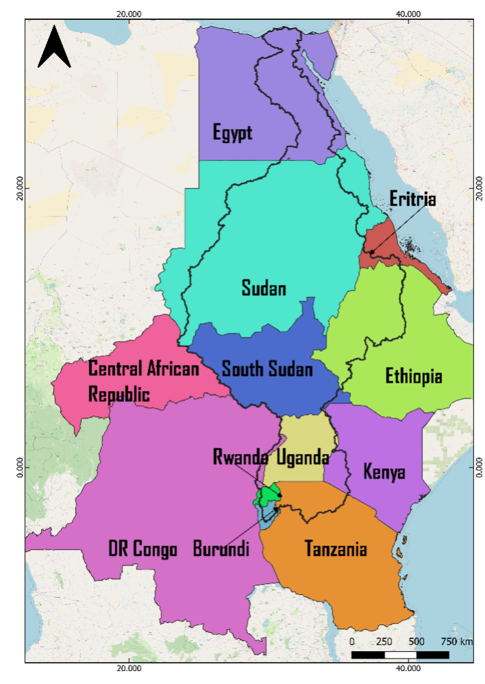
The Nile river basin is the longest river in the world (around 6,800 Km) and the third largest watershed worldwide (around 3.3 Million Km2) after the Amazon river basin (7.2 Million Km2) and the Orinoco river basin (3.8 Million Km2) (Williams, 2018). The Nile is a transboundary watershed that spans over 35° of latitude and crosses 11 countries: Burundi, Democratic Republic Congo (DRC), Egypt, Eretria, Ethiopia, Kenya, Rwanda, Sudan, South Sudan, Tanzania, Uganda. The Nile is the only river around the world that crosses a desert. The watershed has three main tributaries : the white Nile, the Blue Nile, and the Atbara. The white Nile originates in the Equatorial uplands in Uganda, Rwanda, and Burundi, from lake Victoria and flows through lake Kyoga (Uganda) and lake Albert (between Uganda and DRC), then the Sudd swamps in south Sudan until it reaches the confluence point with the Blue Nile in Khartoum Sudan. The Blue Nile and Atabra basin both originate in the Ethiopians highlands and contributes to 60 % , and 20% of the main Nile flow respectively (NBI, 2016; Pacini & Harper, 2016).
Although the Nile River is shared by 11 countries, the distribution is not equal. As shown in Figure 2, the Nile Basin covers nearly the entire territory of Uganda, followed by South Sudan (85.36%), Rwanda (75.46%), and Sudan (68.93%). In contrast, the basin represents only a small portion of other countries such as Tanzania (8.91%), Kenya (7.93%), and the Democratic Republic of Congo (0.94%).
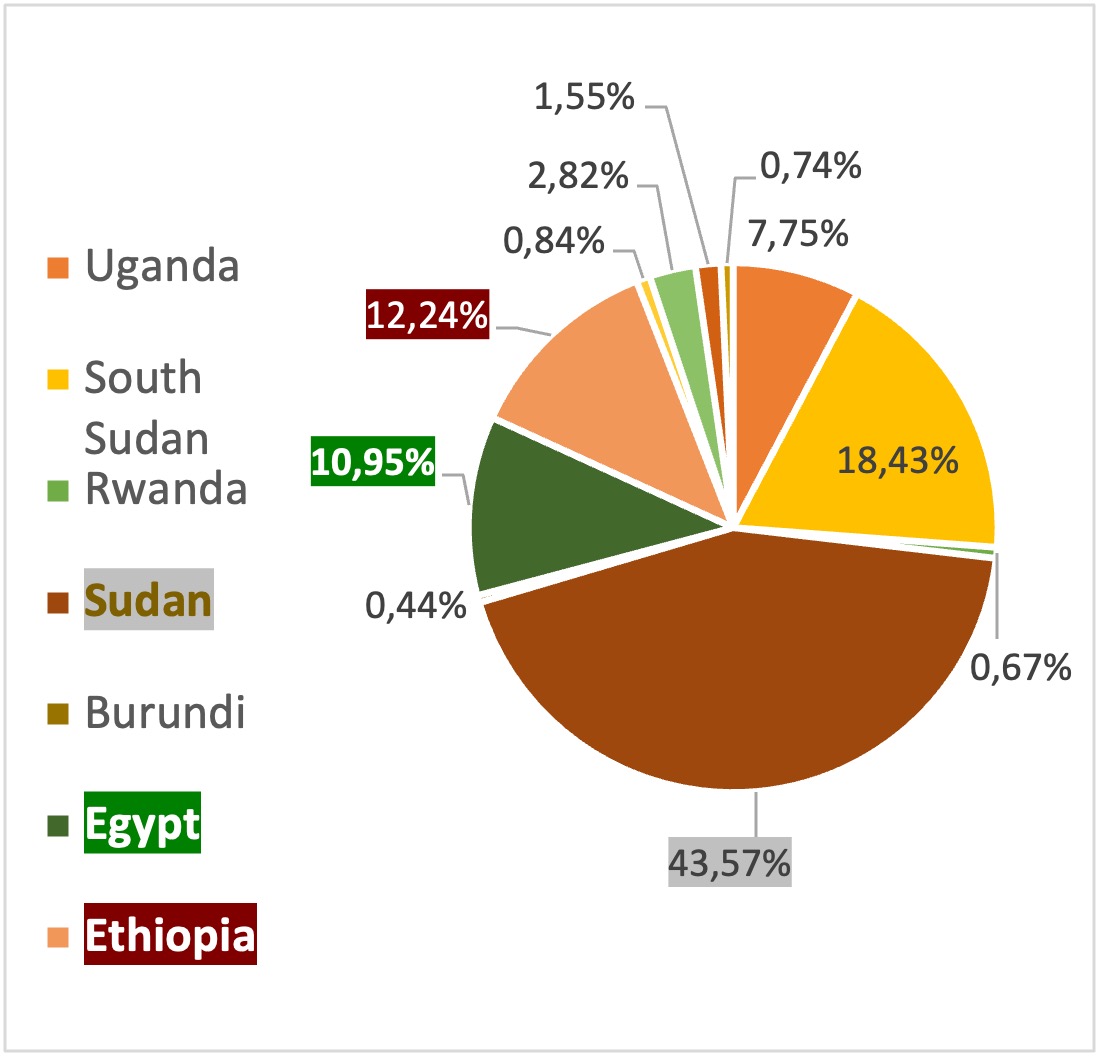
Conversely, the extent to which each riparian country occupies the Nile Basin area also varies. According to Figure 3, Sudan holds the largest share, with slightly less than half of the total basin area lying within its territory (43.57%), followed by South Sudan (18.43%), Ethiopia (12.24%), and Egypt (10.95%).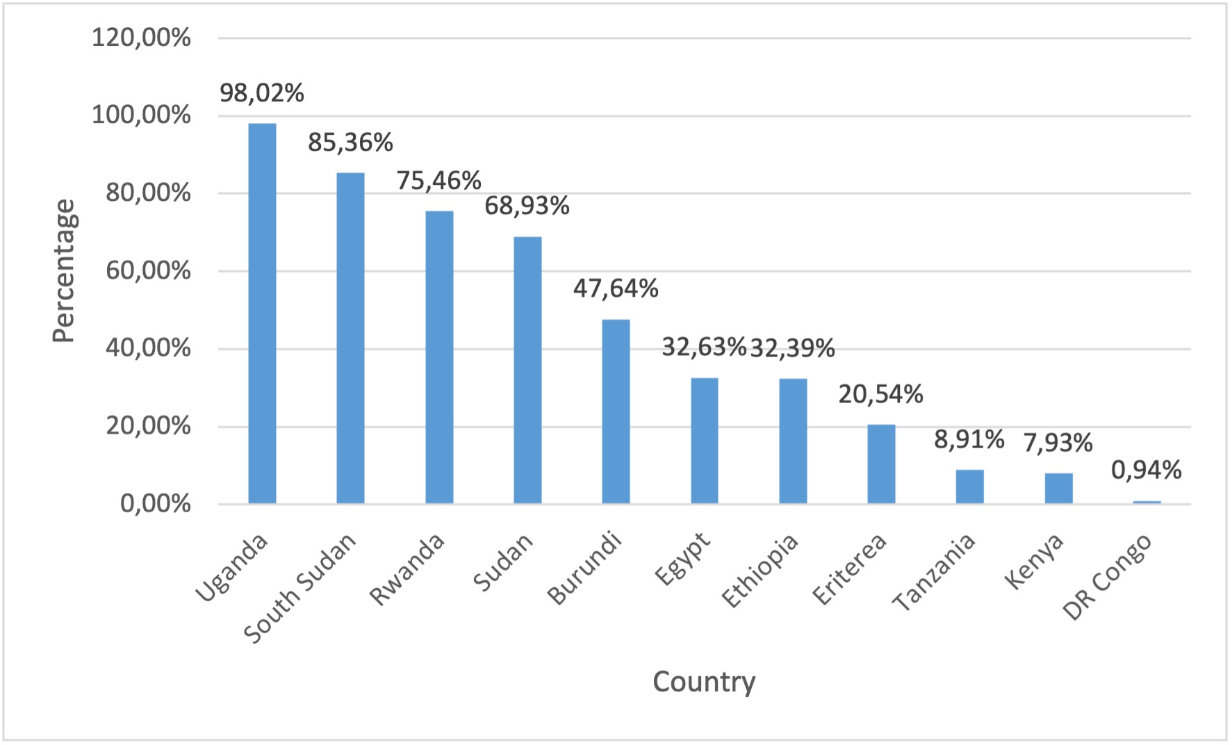
References
ESRI. (2021, April 29). Africa Countries [Shapefile]. doi:https://hub.arcgis.com/datasets/africa::africa-countries/about
Lehner, B., & Grill, G. (2013). Global river hydrography and network routing: baseline data and new approaches to study the world’s large river systems. Hydrological Processes, 27(15), 2171–2186. doi:https://doi.org/10.1002/hyp.9740
NBI. (2016). Chapter 2- Nile Basin Physiography. In N. B. (NBI), Nile Basin Water Resources Atlas (pp. 21-48). Nile Basin Initiative (NBI).
Pacini, N., & Harper, D. M. (2016). Hydrological characteristics and water resources management in the Nile Basin. Ecohydrology & Hydrobiology, 16(4), 242- 254. doi:https://doi.org/10.1016/j.ecohyd.2016.09.001
Williams, M. (2018). 1 - The Nile Basin: An Introduction. In M. Williams, https://doi.org/10.1017/9781316831885.002 (pp. 1-7). Cambridge University Press. doi:https://doi.org/10.1017/9781316831885.002
Contact
Chahinaz Ziani This email address is being protected from spambots. You need JavaScript enabled to view it.