Erft (Germnay)
Natural Environment
The Erft River Basin is in the southwest of North Rhine-Westphalia (NRW) in Germany. It drains a total area of 1850 km2 and the river has a length of 107 km. The Erft River flows generally in a northeasterly to northerly direction through western Germany before joining the Rhine River (Lehner & Grill, 2013; Markert et al., 2020).
Topography
The topography of the Erft watershed is diverse, ranging from hilly terrain with steep slopes (around 1%) in the upstream areas in the Eifel region to flat plains with gradual slopes (0,1%) in the middle and downstream parts of the river basin. The elevation varies between -222m (due to the mining activities) to 585 m, with an average elevation of 170m (World topographic map, 2026).
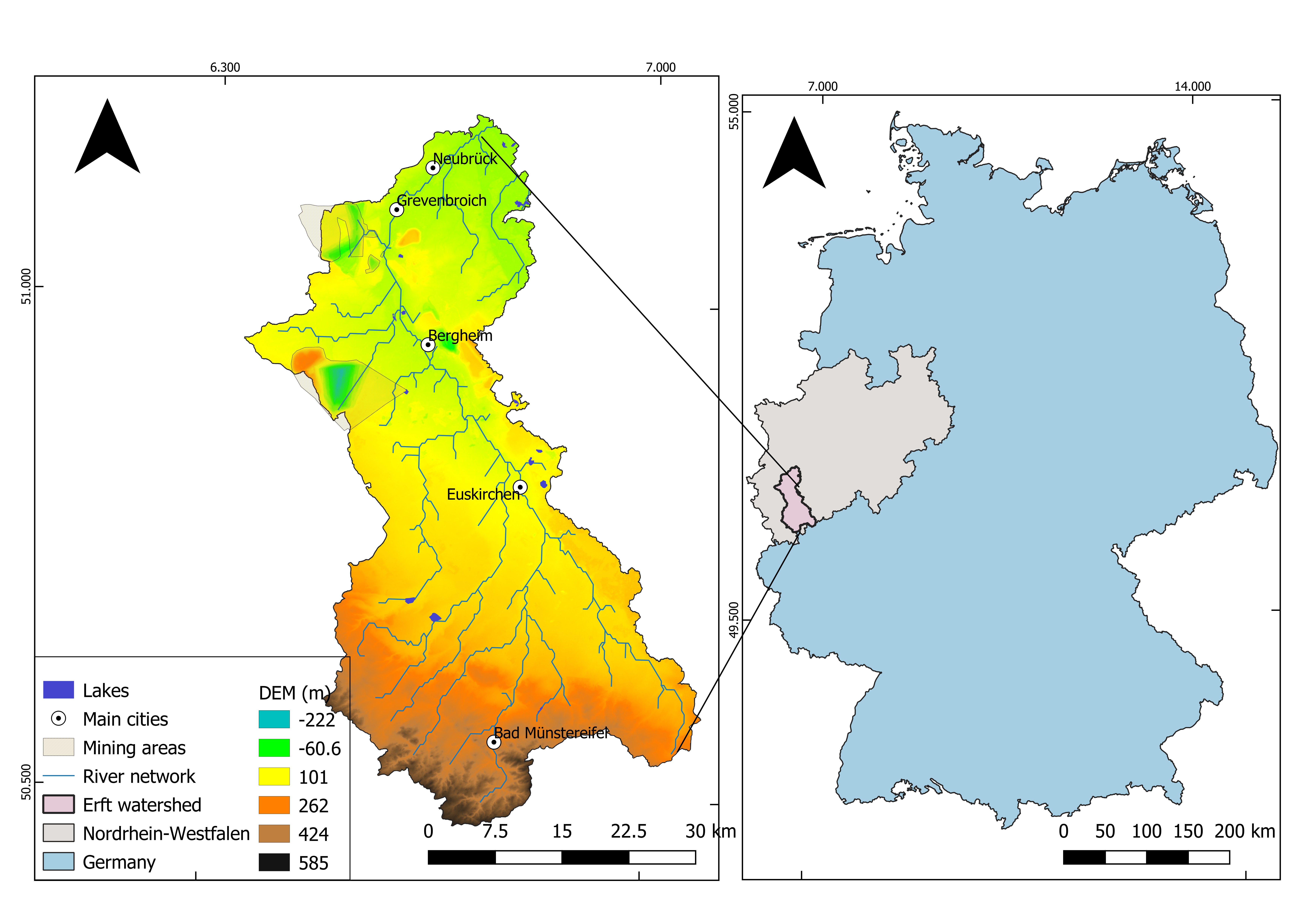
Figure 2: Location Map of the Erft River Basin and Digital Elevation Model (DEM) .(GEOportal, 2022a)
Geology
The Erft River Basin is characterized by a complex geological context dominated by clastic and mixes sediment rocks (figure 3-B), and shaped by fluvial, marine and Aeolian processes (Figure 3-A). This combination indicates that the area is subject to significant soil erosion driven by both wind and water.
Stratigraphy: Over half (52.6%) of the basin's stratigraphic units belong to the Quaternary period, the most recent geological period known for glacial and interglacial cycles. About 34.41% are from the Precambrian to Paleozoic eras, representing much older, basement crystalline and sedimentary rocks underlying younger deposits.
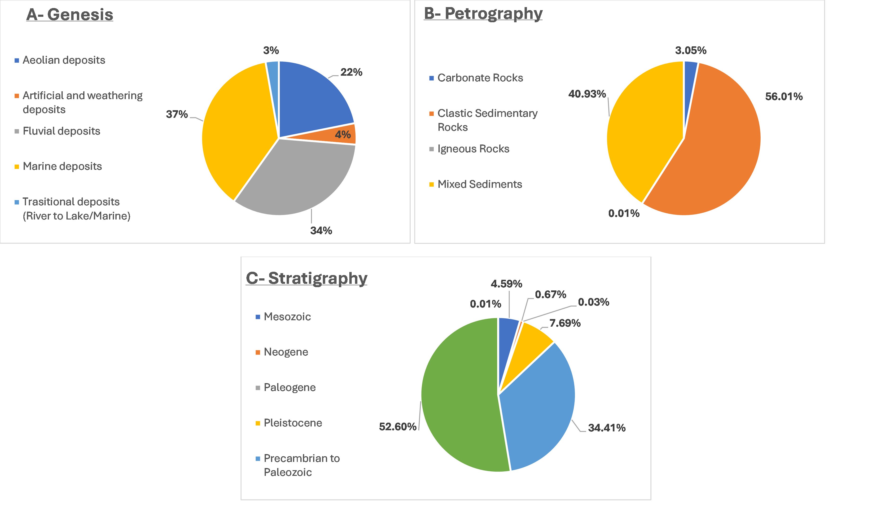
Figure 3: Distribution of (A) Genesis, (B) Petrography, and (C) Stratigraphy Classes in the Erft River Basin (GEOportal, 2022b).
Geologically the Erft river basin is part of the Lower Rhine Gaben (LGB) that spans over a 3.600 km2 and includes North Rhine-Westphalia in Germany, the southern part of The Netherlands and northeastern part of Belgium. The LGB contains several major blocks that are bounded by normal faults, among them the “Wissersheimer-Fault”. This fault travers the city of Kerpen, where the western part of the fault is highly impacted by fluvial and mining activity, due to the proximity (around 10Km) to the Hambach open pit mine. The area knows a significant subsidence (lowering of the ground surface). However, it is difficult to differentiate if this phenomenon is caused by the mining activities or the co-seismic processes in the region (Kübler, 2012).
Soils
The clay silt is the predominant soil texture in the Erft river basin, with around 91.46% of total coverage. This soil type is known by low sand content and almost equal content of silt and clay. The clay, when wet, is known for high water and nutrient holding capacity. The clay can represent challenges in terms of soil water drainage. The silt is a highly fertile soil texture, due to its good air and water circulation feature (Holmes, 2024).
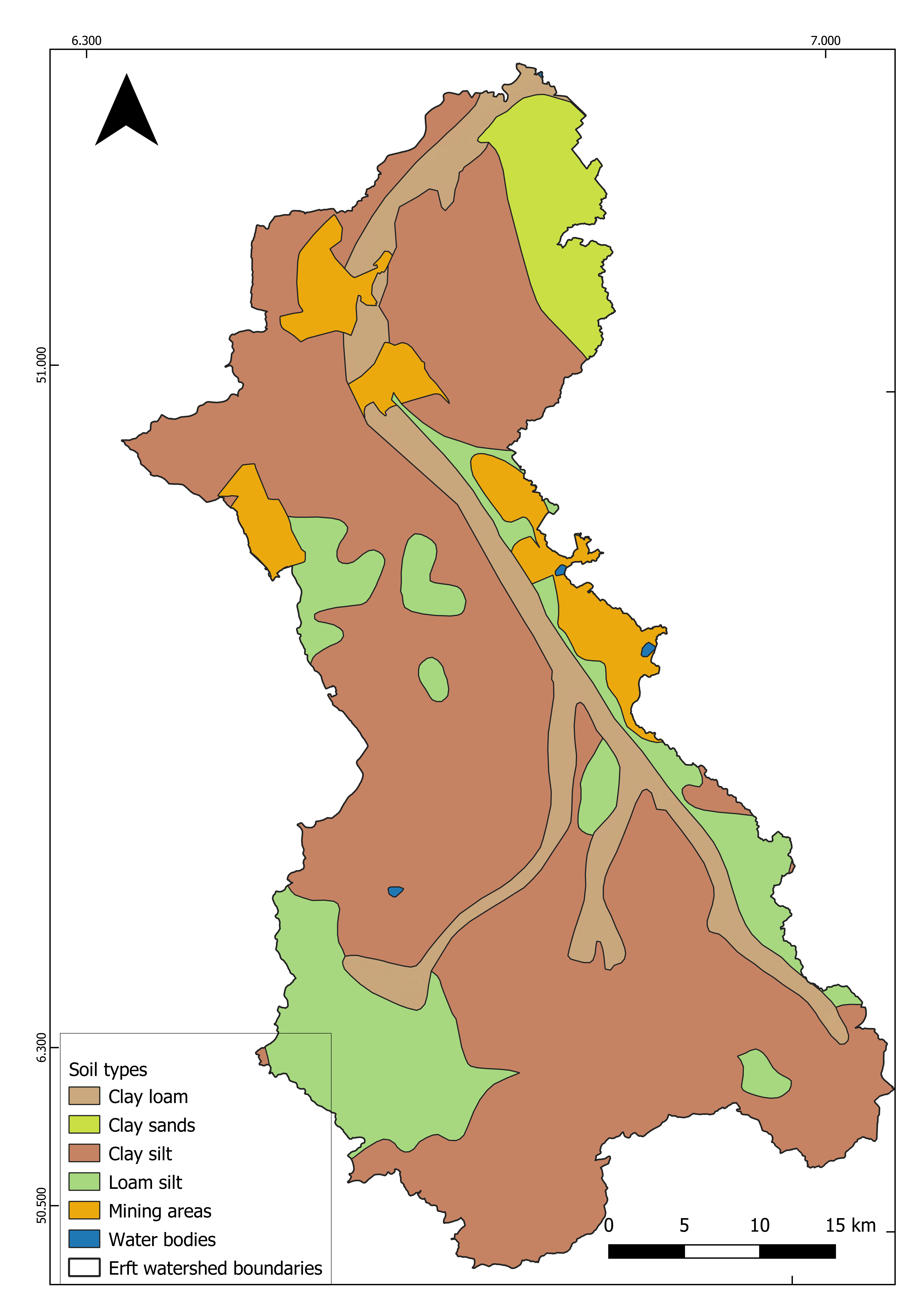
Figure 4: Spatial Distribution of Soil Types in the Erft River Basin (GEOportal, 2022b).
However, the region represents a significant soil erosion challenge, that first takes place in the upper parts of the basin in the mountainous region known with steep slopes and narrow creek valley that are deeply cut into the landscape known as “The Mechernicher Voreifel”.(Christoffels, 2016).
In stormwater and heavy rainfall events, large agricultural areas are subject to erosion, transporting large amounts of sediments, nutrients, heavy metals and nutrients into water courses (example. The Rotbach creek) (Christoffels, 2016).
The soil erosion impacts negatively the hydromorphological condition of the river in addition to the aquatic ecosystem, where the transportation of additional sediment into the sand-gap system leads to the clogging of habitat of organisms living in the watercourses. Moreover, the soil erosion can lead to the damaging of engineering structures existing on the river (ex. Cylinders weirs) due to the transportation of abrasive mineral solids (Christoffels, 2016).
References
Christoffels, E. (2016). The importance of soil erosion for surface waters in the case of Rotbach Creek. 1–14. https://doi.org/10.2495/WP160011
GEOportal. (2022a). Digitales Geländemodell—Rasterweite 1 m—Paketierung: Einzelkacheln [Dataset]. https://www.opengeodata.nrw.de/produkte/geobasis/hm/dgm1_tiff/
GEOportal. (2022b). INSPIRE-WMS NW Hydro—Physische Gewässer ATKIS Basis-DLM [Dataset]. https://www.geoportal.nrw/?activetab=portal
Holmes, K. (2024, November 21). Recognizing the Different Types of Soil. https://www.cropler.io/blog-posts/recognizing-the-different-types-of-soil
Kübler, S. (2012). Active Tectonics of the Lower Rhine Graben (NW Central Europe) Based on New Paleoseismological Constraints and Implications for Coseismic Rupture Processes in Unconsolidated Gravels [Dissertation zur Erlangung des Doktorgrades der Fakultät für Geowissenschaften der Ludwig-Maximilians-Universität München]. Ludwig-Maximilians-Universität München. https://edoc.ub.uni-muenchen.de/15596/1/Kuebler_Simon.pdf
Lehner, B., & Grill, G. (2013). Global river hydrography and network routing: Baseline data and new approaches to study the world’s large river systems. Hydrological Processes, 27(15), 2171–2186. https://doi.org/10.1002/hyp.9740
Markert, N., Rhiem, S., Trimborn, M., & Guhl, B. (2020). Mixture toxicity in the Erft River: Assessment of ecological risks and toxicity drivers. Environmental Sciences Europe, 32(1), 51. https://doi.org/10.1186/s12302-020-00326-5
World topographic map. (2026). Erft topographic map [Elevation Maps]. https://en-us.topographic-map.com/map-mp5znh/Erft/