Erft (Germany)
Hydrology
The Erft river Basin’s hydrology is shaped by tectonic structures, groundwater–surface water interactions, and extensive lignite mining activities that alter regional flow regimes and river discharge patterns (Gumm et al., 2016).
Discharge
Based on time series between 1990 and 2023 from the Neubrueck station (ELWAS-WEB, 2024), located approximately of 8,50 km of the Erft River mouth, the average flow is 9,67 m3/s the maximum discharge is reached in the month of February with a value of 11,63 m3/s and the minimum discharge is reached in the month of September with a value of 8,49 m3/s.
Since the station is downstream, the discharge value is impacted by the Lignite mining in the Erft River Basin. In fact, approximately 250 million cubic meters of groundwater per year, pumped from mines, is discharged into the middle reach of the Erft which impacts the flow levels in the middle and lower portions of the river (Christoffels, 2013).
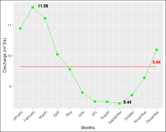
Figure 5: The average value of monthly discharge 2000-2023 from the Neubrueck station (ELWAS-WEB, 2024).
Based on time series between 1990 and 2020 from the Arloff station (ELWAS-WEB, 2024) located upstream, the average flow is 0,63 m3/s the maximum discharge is reached in the month of March with a value of 1,23 m3/s and the minimum discharge is reached in the month of October with a value of 0,21 m3/s.
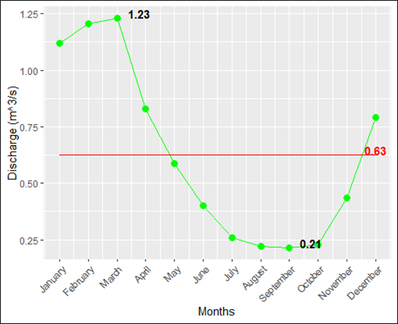
Figure 6: The average value of monthly discharge 1990-2020 from the Arloff station (ELWAS-WEB, 2024).
Groundwater
Groundwater in the Erft river Basin is strongly influenced by the hydrogeological structure of the Lower Rhine Embayment, where multilayered aquifers and tectonic fault systems control regional groundwater flow patterns (Gumm et al., 2016). Open-cast lignite mining in the Rhineland has caused extensive groundwater dewatering, leading to large-scale declines in groundwater levels and long-term changes in groundwater recharge and quality (Wisotzky & Obermann, 2001). The ground east of the Hambach mine has sunk more than the land around the river’s outfall, reducing the natural slope toward the Erft River by approximately 0.5% (Forkel et al., 2019). Scientific studies also show that groundwater management in the Erft river Basin is essential for protecting drinking water resources and maintaining wetland ecosystems affected by mining activities (Erftverband, 2026).
References
Christoffels, E. (2013). Online water quality monitoring: A network to support water management in the Erft river basin. 409–420. https://doi.org/10.2495/RBM130341
ELWAS-WEB. (2024). Daten [Dataset]. https://www.elwasweb.nrw.de/elwas-web/index.xhtml
Erftverband. (2026). Groundwater. https://www.erftverband.eu/blog/groundwater
Forkel, C., Hassel, S., Rinaldi, P., & Müller, C. (2019). Restoration of Groundwater Levels in the Rhineland Lignite Basin. https://mining-report.de/wp-content/uploads/_pda/2019/06/MRG_1903_RWE_Grundwasserwiederanstieg_190607.pdf
Gumm, L. P., Bense, V. F., Dennis, P. F., Hiscock, K. M., Cremer, N., & Simon, S. (2016). Dissolved noble gases and stable isotopes as tracers of preferential fluid flow along faults in the Lower Rhine Embayment, Germany. Hydrogeology Journal, 24(1), 99–108. https://doi.org/10.1007/s10040-015-1321-7
Wisotzky, F., & Obermann, P. (2001). Acid mine groundwater in lignite overburden dumps and its prevention—The Rhineland lignite mining area (Germany). Ecological Engineering, 17(2–3), 115–123. https://doi.org/10.1016/S0925-8574(00)00152-X