NILE BASIN RESEARCH (N-AFRICA)
Hydrology
The hydrology of the Nile Basin is notably distinct from that of other major river basins, such as the Amazon, Congo, or Mississippi. The Nile basin is the only river basin with a “South- North” flow direction linking the Equatorial Africa to the North part of the continent, representing the only remaining corridor for animals and humans in this direction (Pacini & Harper, 2016).
However, a large portion of the Nile Basin is hydrologically inactive. More than 40% of the basin receives less than 1,500 mm of rainfall per year, much of which falls within arid and hyper-arid regions. As a result, these areas contribute minimally to the Nile’s direct runoff. Moreover, around 89% of the rain falling on the Nile basin comes from outside the watershed. Therefore, changes in the rainfall patterns in the region, makes the Nile very vulnerable in terms of amount of precipitation received (Pacini & Harper, 2016).
The average discharge of the main Nile measured at Aswan is around 85Km3/year, leading to a specific discharge of 0.27m/year, which is the lowest specific discharge of any large basin (The Amazon 9.6m, The Mississippi 1.8 m, The Congo 3.2m, and the Ganges 3.8m) (Pacini & Harper, 2016). The contribution of the main tributaries is highly different. The Blue-Nile (Abbay in Ethiopia) originating in the Ethiopian highlands contributes with around 60% (or 4/7) of the total Nile runoff (Mohmed et al., 2005; Basheer et al., 2024). The White Nile originates in the Lake Victoria and contributes of around 28% (2/7) of the total discharge of the Nile basin (Mohamed et al., 2005; Senay et al., 2014). The remaining discharge comes mainly from the Atbara sub-Basin that also originates from the Ethiopian highlands (Pacini & Harper, 2016; Basheer et al., 2024).
Both the Atbara and the Blue Nile provide to the Nile during a single wet season (June-September) more than 90% of the total Nile flow (Pacini & Harper, 2016), where 80% comes solely from the Blue Nile (Basheer et al., 2024)
Water balance
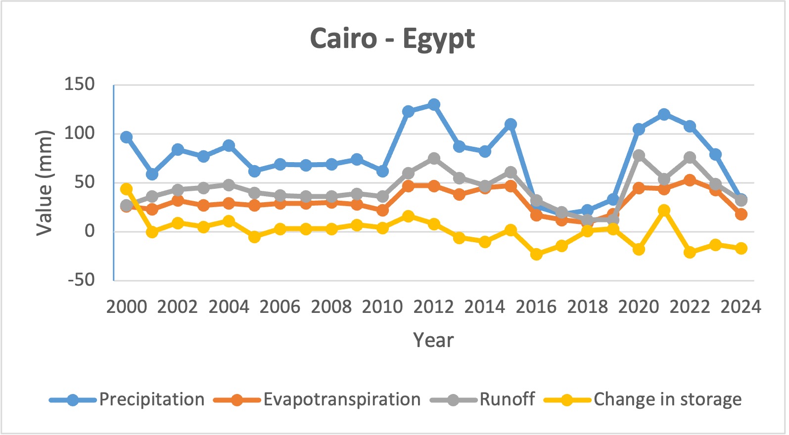
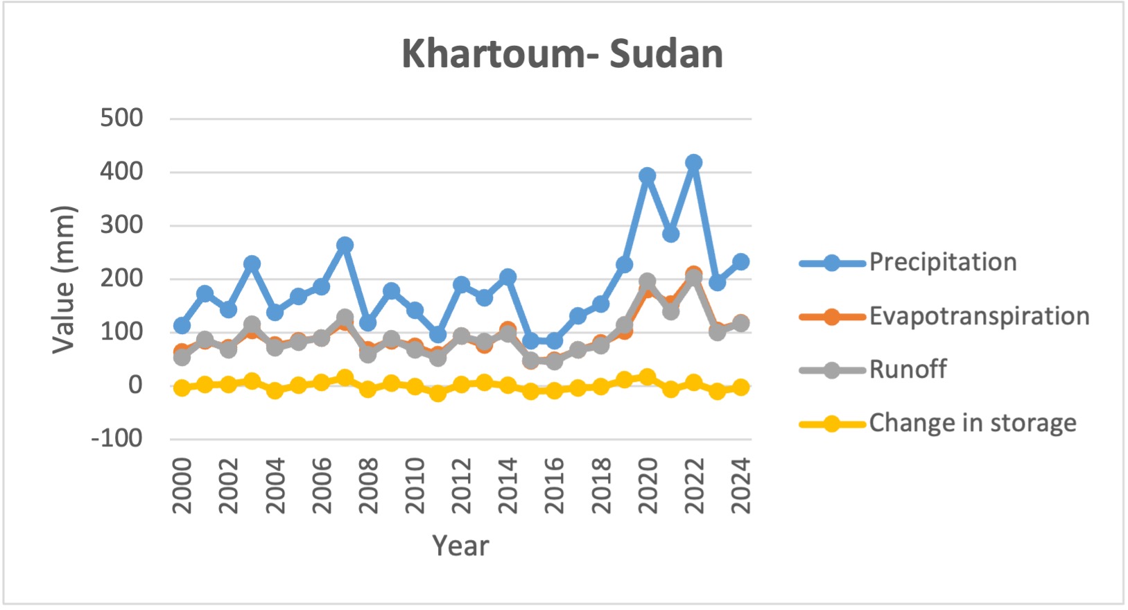
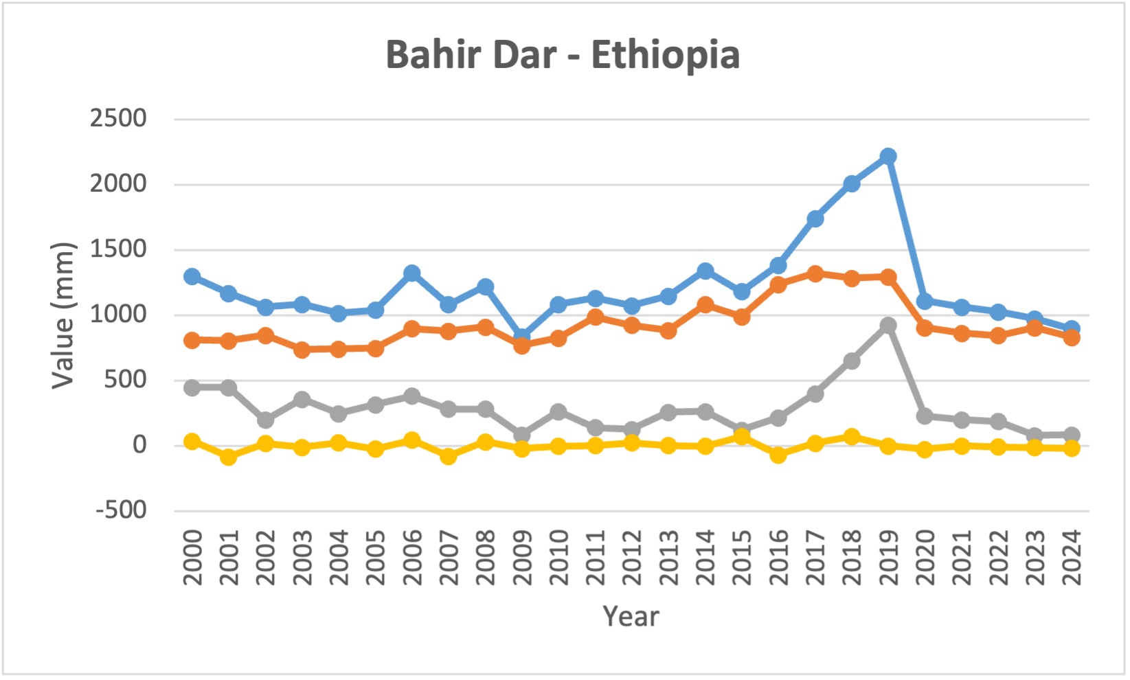
Significant spatial and temporal variability in the hydrological processes characterizing the Nile Basin. Based on the data extracted from water balance app from ESRI in three different locations in the Nile basin we have:
Cairo – Egypt: Precipitation are consistently low (below 130 mm/year), evapotranspiration is also minimal (50mm/year), and the runoff remains small but fluctuating through the years indicating the high influence by upstream water flows rather than local precipitation. This situation affects high the changes in storage that proves the high reliance on upstream waters resources to maintain hydrological fluxes.
Khartoum- Sudan : with a highly fluctuating precipitation rate (between 85 – 418 mm/year) and moderate evapotranspiration rates, the runoff volume depends highly of the rainfall amount, which lead to a fluctuation in the changes of storage with negative values during dry years (e.g., 2011–2016), indicating reduced water availability.
ahir Dar- Ethiopia: has high precipitation rates comparing to the above mentioned locations with an average value of 1,000 mm/year, in addition to high evapotranspiration rates due to the humid climate, the proximity to lake Tana and substantial dense vegetation. These elements impacts the runoff and the change in storage that are highly variating.
Basheer, M., Siddig, K., & & Ringler, C. (2024). Water-energy-food planning and operations framework for river basins with a case study on the Blue Nile. Journal of Hydrology. Retrieved from https://doi.org/10.1016/j.jhydrol.2024.130801
Mohamed, Y. A., van den Hurk, B. J., Savenije, M. H., & Bastiaanssen, M. W. (2005). Impact of the Sudd wetland on the Nile hydroclimatology. Water Resources Research, 41(8). Retrieved from https://doi.org/10.1029/2004WR003792
Pacini, N., & Harper, D. M. (2016). Hydrological characteristics and water resources management in the Nile Basin. Ecohydrology & Hydrobiology, 16(4), 242- 254. doi:https://doi.org/10.1016/j.ecohyd.2016.09.001
Senay, G. B., Velpuri, N. M., Bohms, S., & Demissie, Y. (2014). Understanding the hydrologic sources and sinks in the Nile Basin using multisource climate and remote sensing data sets. Water Resources Research, 50, 8625–8650. doi:doi:10.1002/2013WR015231