NILE BASIN RESEARCH (N-AFRICA)
Water Users/ Stakeholders
Water infrastructures
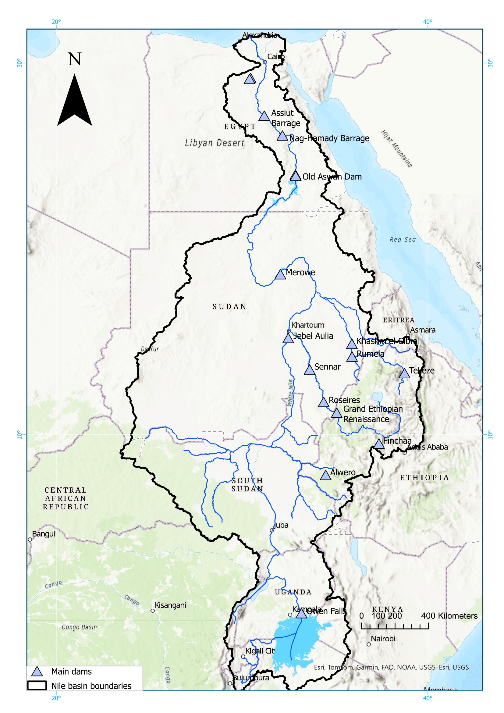
According to (NBI, 2024), the riparian countries has in total 827 dams (all types included), 190 of them are located in Ethiopia. The main dams of the Nile basin are shown in Figure 1 with their main characteristics summarized in Table 1.
Table 1: Characteristics of the main dams in the Nile Basin.
|
Dam name |
Country |
River |
Purpose |
Commisioning date |
Reservoir volume (Mm3) |
Dam height (m) |
|
Owen Falls |
Uganda |
White Nile |
Hydropower, Irrigation |
1954 |
204.0 |
30.0 |
|
Alwero |
Ethiopia |
Alwero |
Irrigation |
1995 |
74.6 |
22.0 |
|
Fincha |
Ethiopia |
Finchaa |
Hydropower, Water supply, Irrigation |
1973 |
940.0 |
22.0 |
|
Grand Ethiopian Ren aissance Dam (GERD) |
Ethiopia |
Blue Nile |
Hydropower |
74,000.0 |
175.0 |
|
|
Roseries |
Sudan |
Blue Nile |
Hydropower, Irrigation, Flood control |
1966 |
5,900.0 |
78.0 |
|
Tekeze |
Ethiopia |
Tekeze |
Hydropower, Irrigation, Flood control, Fishing |
2009 |
9,293.0 |
188.0 |
|
Rumela |
Sudan |
Upper Atbara |
Hydropower, Irrigation, Flood control, Water supply |
2016 |
3,300.0 |
55.0 |
|
Khashm El Gibra |
Sudan |
Atbara |
Hydropower, Irrigation |
1964 |
1,300.0 |
50.0 |
|
Sennar |
Sudan |
Blue Nile |
Hydropower, Irrigation |
1925 |
930.0 |
39.5 |
|
Jebel Aulia |
Sudan |
White Nile |
Hydropower, Irrigation, Flood control, Navigation |
1937 |
3,500.0 |
22.0 |
|
Merowe |
Sudan |
Nile |
Hydropower, Irrigation, Flood control |
2009 |
12,400.0 |
74.0 |
|
High Aswan Dam |
Egypt |
Nile |
Irrigation |
1970 |
162,000 |
181.0 |
|
Nag- Hamady Dam |
Egypt |
Nile |
Irrigation |
1930 |
- |
62.0 |
|
Assiut Dam |
Egypt |
Nile |
Irrigation |
1902 |
- |
46.0 |
The Nile Basin includes natural lakes such as Victoria, Edward, Kyoga, and Albert on the White Nile, and Lake Tana in the Blue Nile (Pacini & Harper, 2016)
The Nile basin contains large irrigation schemes mainly located in Egypt and Sudan, while the rest of the riparian countries have together a total irrigated area of around 1 Million ha:
In Sudan: Gezira (constructed in 1925); the Gunied (1962), the Managil extension of Gezira (1966), Suki (1971), North West Sennar (1972), and Rahad 1 (1977). The Gezira and Managil represent 50% of the total irrigated areas in Sudan, and one of the biggest irrigation schemes worldwide (Basheer et al., 2024).
In Egypt: In addition to the Nile Valey and Nile Delta that provides irrigation water from the Aswan dam for more than 3.5 Million ha, other irrigation schemes located outside the Nile boundaries are (such as the one near Toshka Lakes) provides their water from Lake Nasser via a pumping station, especially during the low flow years (1998-2003) (Senay et al., 2014).
Table 1: Irrigated area per country in the Nile Basin.
|
Country |
Irrigated
(ha * 1,000) |
Equipped (ha * 1,000) |
|
Burundi |
14.9 |
8.8 |
|
Egypt |
6,529.6 |
3,823.7 |
|
Ethiopia |
455.4 |
547.4 |
|
Kenya |
33.2 |
61.3 |
|
Rwanda |
7.7 |
8.9 |
|
South Sudan |
265.1 |
111.4 |
|
Sudan |
1,381.3 |
2,023.8 |
|
Tanzania |
32.2 |
33.4 |
|
Uganda |
14.7 |
21.2 |
Source: (Nile-SEC, 2022)
References:
Basheer, M., Siddig, K., & & Ringler, C. (2024). Water-energy-food planning and operations framework for river basins with a case study on the Blue Nile. Journal of Hydrology. Retrieved from https://doi.org/10.1016/j.jhydrol.2024.130801
Mohamed, Y. A., van den Hurk, B. J., Savenije, M. H., & Bastiaanssen, M. W. (2005). Impact of the Sudd wetland on the Nile hydroclimatology. Water Resources Research, 41(8). Retrieved from https://doi.org/10.1029/2004WR003792
NBI. (2024, July 08). Nile Basin Dams Database. Retrieved from https://dams.nilebasin.org/
Nile-SEC. (2022, November). Nile Basin Socio-Economic Outlook 2050 - NBI Technical Reports - WRM-2022-15. Entebbe, Uganda: Nile Basin Initiative (NBI). Retrieved from https://nilebasin.org/sites/default/files/2023-09/Strategic-SocioEconomic-Outlook-final-170323.pdf
Pacini, N., & Harper, D. M. (2016). Hydrological characteristics and water resources management in the Nile Basin. Ecohydrology & Hydrobiology, 16(4), 242- 254. doi:https://doi.org/10.1016/j.ecohyd.2016.09.001
Senay, G. B., Velpuri, N. M., Bohms, S., & Demissie, Y. (2014). Understanding the hydrologic sources and sinks in the Nile Basin using multisource climate and remote sensing data sets. Water Resources Research, 50, 8625–8650. doi:doi:10.1002/2013WR015231
Eastern Nile Research Universities and Centers
The Eastern Nile Research Universities and Centers (ENRUC) is a coalition of universities and research institutions from Egypt, Ethiopia, and Sudan, that is complemented by contributions from water ministries, civil society organizations, and international academic collaborators. The network focuses on addressing critical challenges related to the management of the Nile Basin, which holds immense ecological, economic, and geopolitical significance. ENRUC serves as a hub for research, knowledge exchange, and scientific collaboration aimed at fostering sustainable water and land management practices in the Eastern Nile Basin.
The establishment on the ENRUC network was launched in 2018 with a duration of three years, and it is currently in its second phase, with the following objectives:
- • Enhance knowledge exchange among researchers in the Eastern Nile basin
- • Enhance the public presence of the ENRUC
- • Create a Nile Research Portal to feature an archive of information, analyses and publications related to the research conducted in the Nile basin
These objectives are reached through:
The organization of frequent online webinars and in person workshops
The creation of an online portal for the ENRUC, sharing information, and latest events of the network and their members.