Erft (Germany)
Socioeconomic Development
The Erft river basin socio-economic state is closely linked to decades of lignite mining, which has shaped local employment structures, industrial activity, and regional value chains in North Rhine-Westphalia (Federal Ministry for Economic Affairs and Energy (BMWi), 2019). At the same time, the region is undergoing structural change as the coal phase-out drives investment in new sectors such as research, energy transition technologies, and services to replace mining-related jobs (Fromhold-Eisebith & Fahl, 2026).
Population and Human environment
The catchment hosts an uneven distribution of inhabitants, with higher concentrations clustered around the main urban centers, Grevenbroich and Bergheim in the north, Erftstadt in the middle, and Euskirchen in the south, while rural and agricultural zones remain lightly settled. In the more urbanized northern area of the catchment, population density reaches up to 640 inhabitants per km².
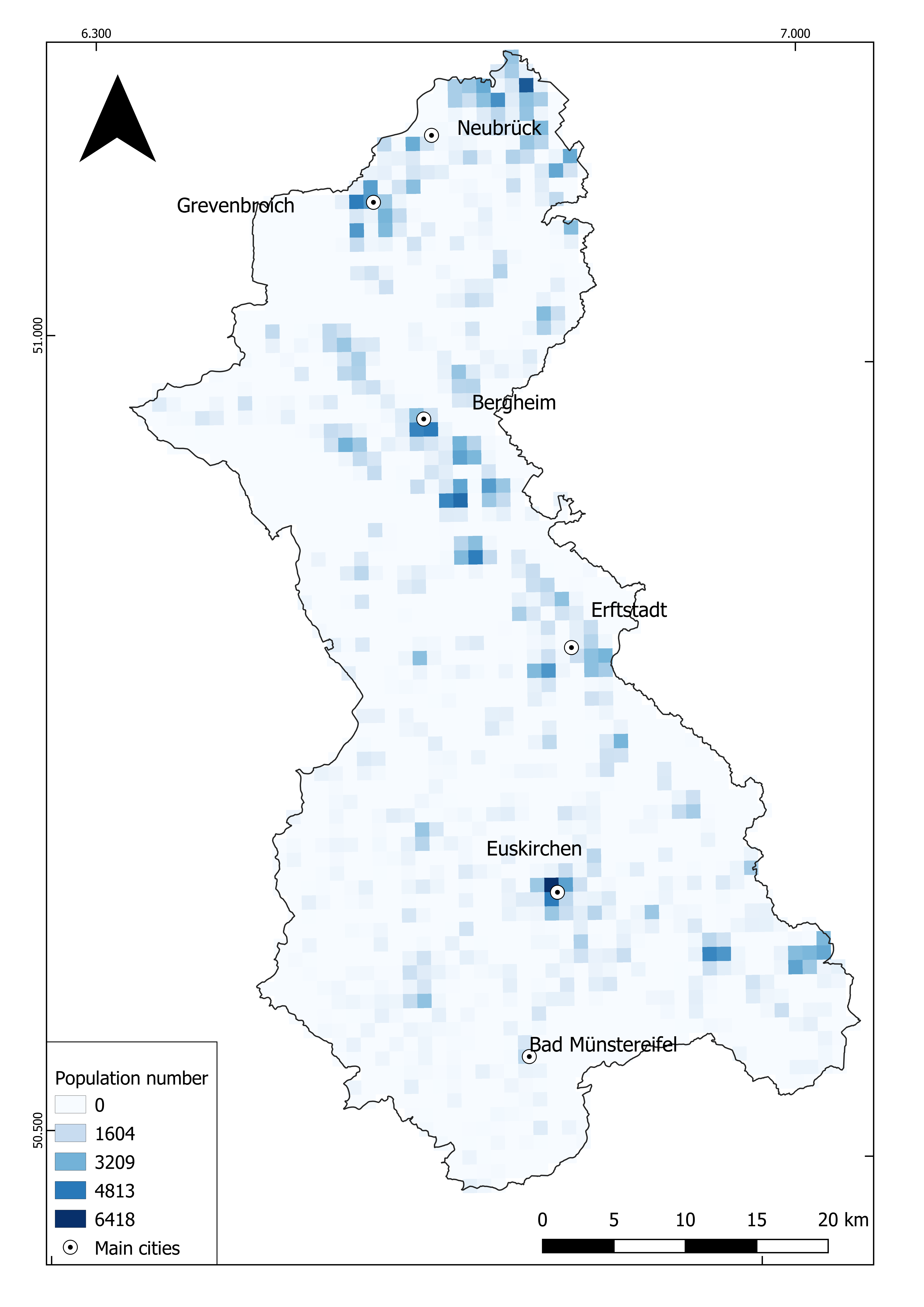
Figure 7: Population distribution in the Erft river basin (GHSL, 2020).
The settlement distribution map (figure 8) reveals a fragmented landscape combining scattered rural villages, peri-urban expansion zones, industrial and commercial areas, and large open-cast mining quarries.
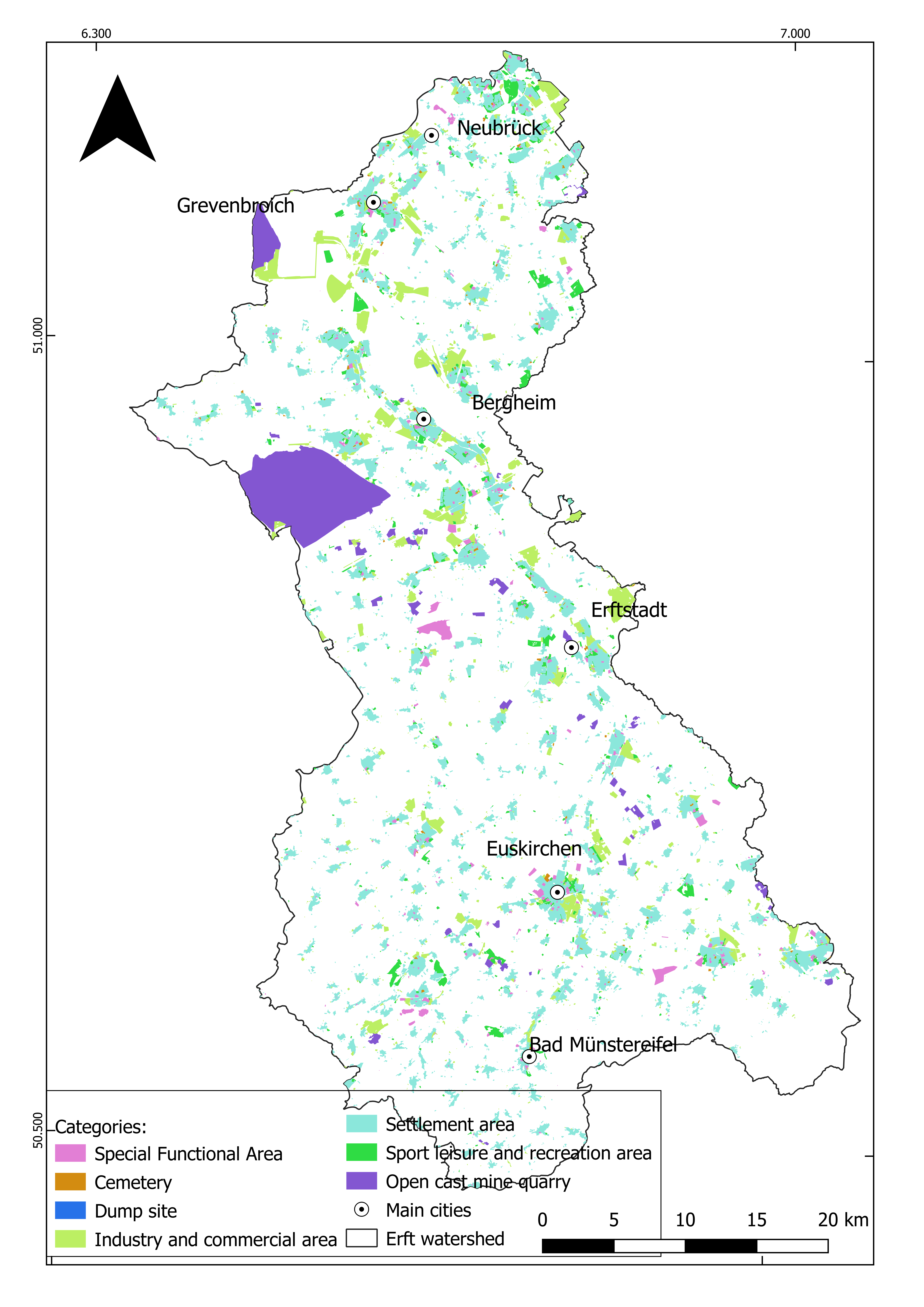
Figure 8: Settlement distribution map (GEOportal, 2022b).
The social infrastructure map shows a relatively dense network of schools distributed across the basin, with hospitals concentrated in the larger urban centers. This pattern shows that educational facilities are dispersed while specialist healthcare is centralized. The location of hospitals primarily in Grevenbroich, Bergheim, Erftstadt, and Euskirchen reflects the polycentric structure of settlement in the basin, where several medium-sized towns function as regional service hubs for surrounding rural municipalities.
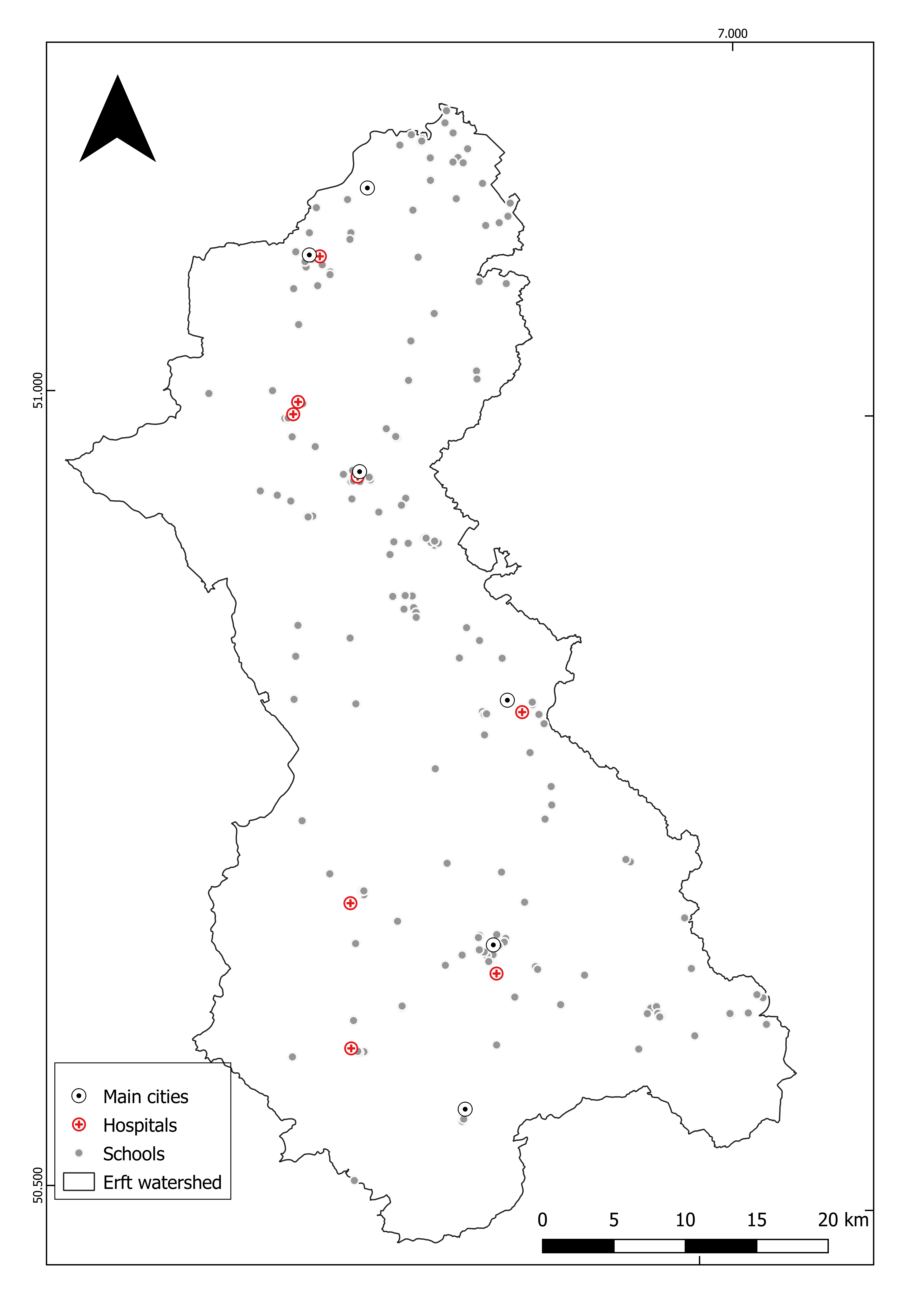
Figure 9: Social infrastructure map (Hospitals and schools) (GEOportal, 2022b).
The transport network demonstrates high connectivity. The basin is crossed by a dense road network. The rail network includes both passenger and freight lines of considerable importance. Several airports are also visible within and around the basin boundaries.
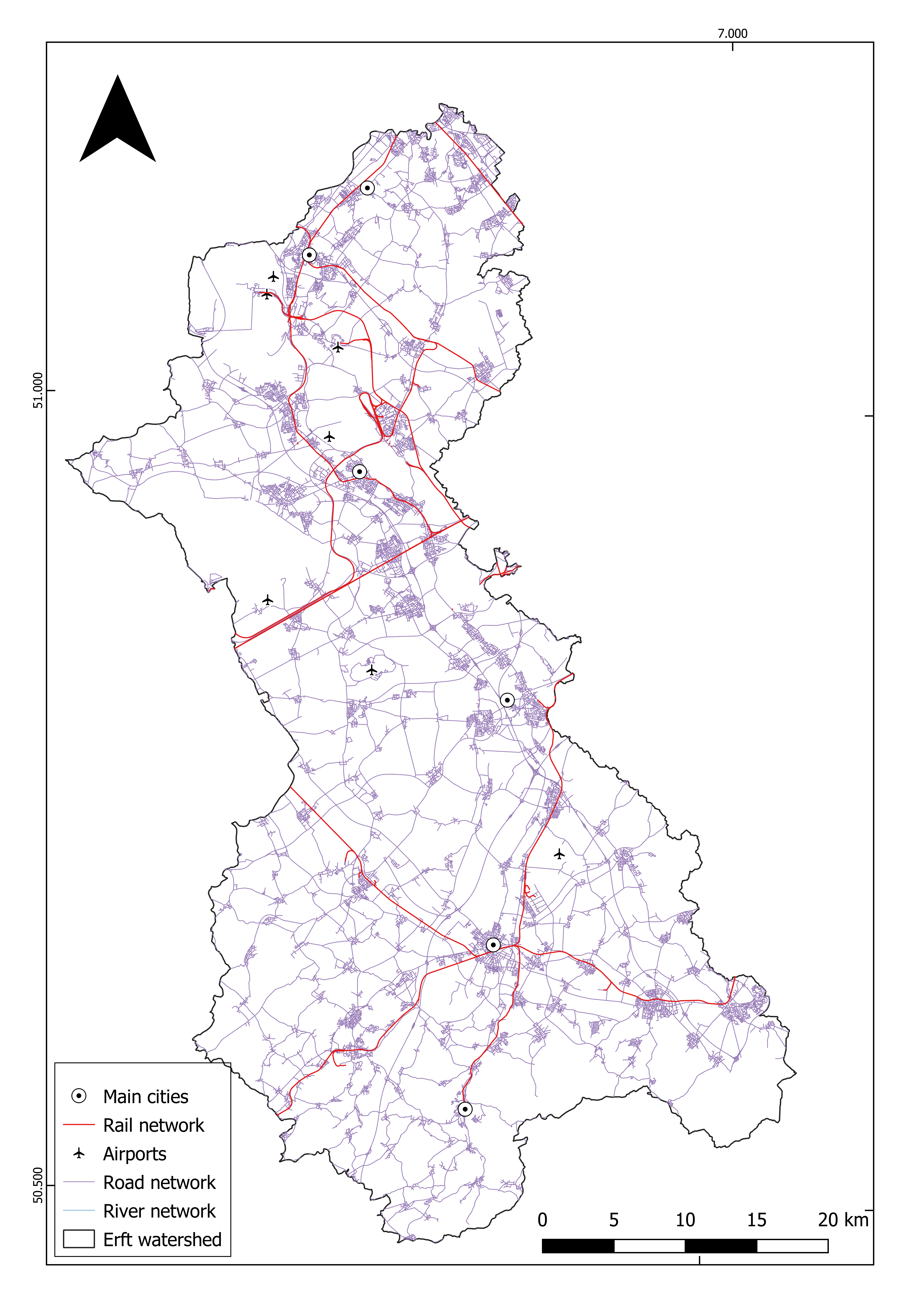
Figure 10: Map for transport networks (GEOportal, 2022b).
The infrastructure map reveals a substantial network of wastewater treatment plants (WWTPs) distributed throughout the basin along the river and its tributaries. Within the Erft catchment, 26 wastewater treatment plants provide advanced treatment services for populations of varying sizes (Ehalt Macedo et al., 2022). Regarding energy production, the basin hosts 11 power plants according to the Global Power Plant Database of which 9 are coal (lignite) power plants; including the major RWE facilities at Niederaussem in Bergheim and Neurath; alongside 1 solar and 1 gas power plant (Byers et al., 2025).
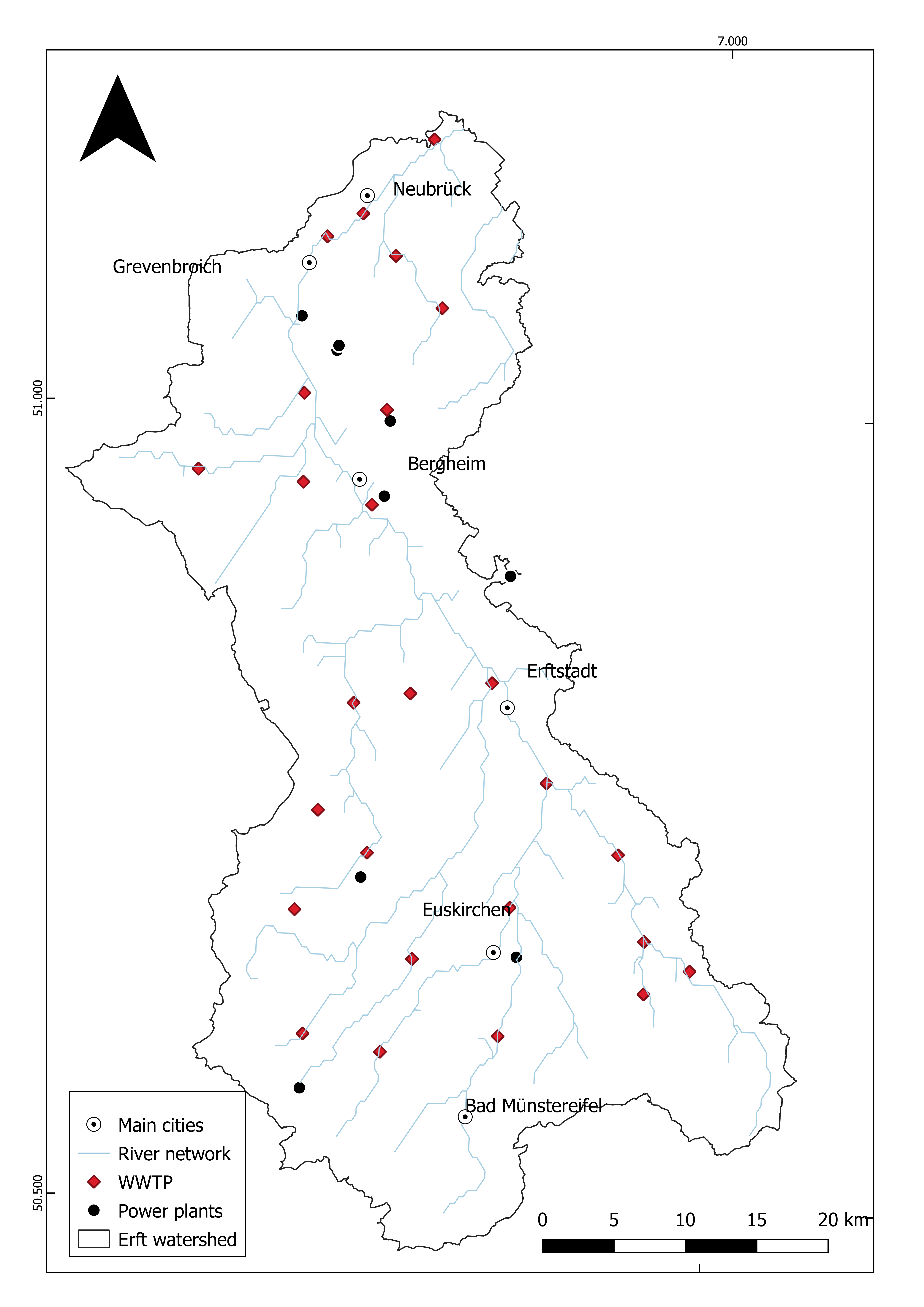
Figure 11: Wastewater Treatment and Energy Infrastructure (GEOportal, 2022b).
Land Use and Land Cover
Based on (ESRI, 2024) data representing the 2024 landcover in the Erft River basin, the agricultural area is the main land cover in the basin (62.50% of the total area), forest and grassland are dispersed throughout the basin on small surfaces with a more important distribution in the upper part (17.99% of the total area), the urban area is also scattered in the basin, mostly, located near the industrial zones (14.29% of the total area). Wetlands and protected areas are concentrated in the southern part of the basin and along the main stream of the river network (GEOportal, 2022b). The catchment is also known for mining and industrial activities, representing, 5.7% over the watershed (Buschmann, 2012).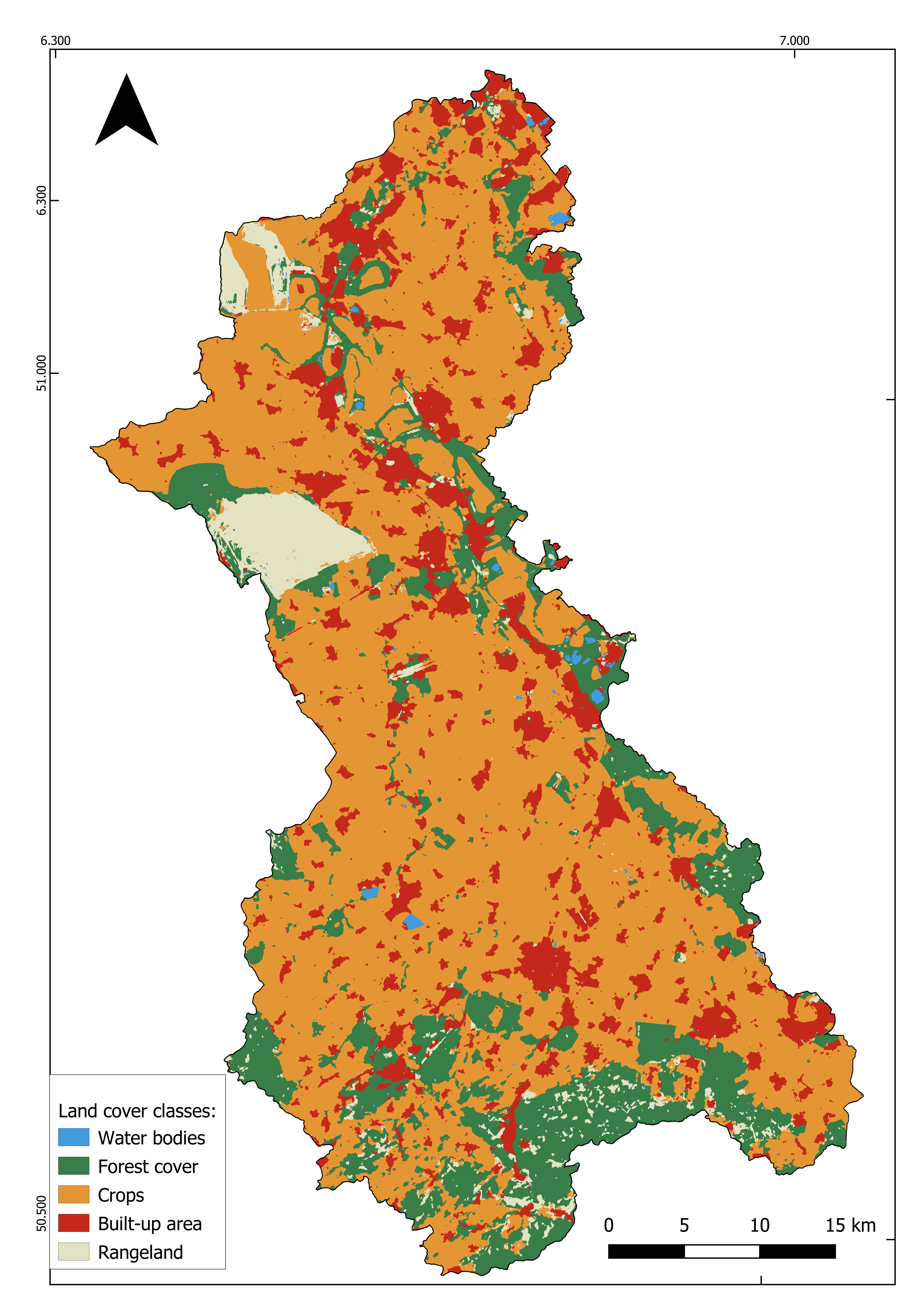
Figure 12: LULC distribution in 2024 (ESRI, 2024).
Anthropogenic activities impact on the basin
Large-scale lignite mining has caused groundwater extraction and land subsidence, leading to changes in river discharge and groundwater flow patterns (Gumm et al., 2016).The ground east of the Hambach mine has sunk more than the land around the river’s outfall, reducing the natural slope toward the Erft River by approximately 0.5% (Forkel et al., 2019). Agricultural activities in the basin contribute to nutrient and pesticide inputs that can influence surface water and groundwater quality (Christoffels, 2016; Markert, 2024). Wastewater discharges from treatment plants additionally affect river water chemistry and temperature conditions (Christoffels, 2016; Markert, 2024). Scientific studies emphasize that sustainable water management and ecological restoration measures are necessary to reduce long-term human impacts on the Erft River Basin (Markert, 2024).
River restoration project in the Erft River Basin
River restoration efforts have gained significant attention as a mean to mitigate ecological degradation caused by human activities such as dam construction, pollution, and channelization (Kollmann et al., 2019). With lignite mining set to cease by 2030, the river's flow will decrease to a third of its current level, necessitating a morphological redesign to accommodate future drainage conditions. Report from planning unit profiles for the TEZG Rhein/Erft NRW shows that only the uppermost planning unit of the river is in good ecological condition while the all other planning unit have the unsatisfactory status and lacks the compliance with standards (MULNV NRW et al., 2021). Thus, the Perspective Concept Erft outlines this redesign, dividing the 40-kilometre river section into 23 projects aimed at enhancing ecological diversity (Erftverband, 2024a). Furthermore, riverscape vegetation has become critical in river restoration projects for various reasons including the fact that vegetation is an indicator that reacts strongly and quickly to any changes in site conditions (Bauer et al., 2018). The vegetation features or habitats that can be found in the riverscape are woodlands and grasslands, riparian vegetation, large floodplain wetlands, marginal and instream macrophytes, and islands. According to O’Briain et. al. (2024), the vegetation influences the hydrogeomorphic connectivity of the riverscape. It contributes to the development of the riverscape (e.g. braiding, meandering etc.) over time through bio-geomorphic succession processes which increase the riverbanks and improve the stability of the floodplain. Additionally, the vegetation contributes to flood management by regulating the magnitude of the flood event and the dispersion of sediments and organic material through the river system (O’Briain et al., 2024).
References
Bauer, M., Harzer, R., Strobl, K., & Kollmann, J. (2018). Resilience of riparian vegetation after restoration measures on river Inn. River Research and Applications, 34(5), 451–460. https://doi.org/10.1002/rra.3255
Buschmann, W. (2012). Erft und Erftflutkanal. Rheinische Industriekultur e.V. https://www.rheinische-industriekultur.com/seiten/objekte/orte/bergheim/objekte/erft_erftflutkanal.html
Byers, L., Friedrich, J., Hennig, R., Kressig, A., & Li, X. (2025). Global Power Plant Database [Dataset]. https://datasets.wri.org/datasets/global-power-plant-database
Christoffels, E. (2016). The importance of soil erosion for surface waters in the case of Rotbach Creek. 1–14. https://doi.org/10.2495/WP160011
EEA, E. E. A. (2019). CORINE Land Cover 2018 (vector), Europe, 6-yearly—Version 2020_20u1, May 2020 (Version 20.01) [FGeo,Spatialite]. European Environment Agency. https://doi.org/10.2909/71C95A07-E296-44FC-B22B-415F42ACFDF0
Ehalt Macedo, H., Lehner, B., Nicell, J., Grill, G., Li, J., Limtong, A., & Shakya, R. (2022). Distribution and characteristics of wastewater treatment plants within the global river network. Earth System Science Data, 14(2), 559–577. https://doi.org/10.5194/essd-14-559-2022
Erftverband. (2024). Neuss-Gnadental. https://www.erftverband.de/gewaesserprojekt-neuss-gnadental/
ESRI. (2024). Sentinel-2 annual land cover (Global LULC Time Series 2024). ArcGIS Living Atlas of the World. [Dataset]. https://livingatlas.arcgis.com/landcoverexplorer/#mapCenter=147.74397%2C-37.18990%2C11.00&mode=step&timeExtent=2017%2C2024&year=2024
Federal Ministry for Economic Affairs and Energy (BMWi). (2019). Commission on Growth, Structural Change and Employment [Final Report]. https://www.bundeswirtschaftsministerium.de/Redaktion/EN/Publikationen/commission-on-growth-structural-change-and-employment.pdf?__blob=publicationFile&v=1
Forkel, C., Hassel, S., Rinaldi, P., & Müller, C. (2019). Restoration of Groundwater Levels in the Rhineland Lignite Basin. https://mining-report.de/wp-content/uploads/_pda/2019/06/MRG_1903_RWE_Grundwasserwiederanstieg_190607.pdf
Fromhold-Eisebith, M., & Fahl, F. (2026). Regional resilience as a foresight approach: Conceptualization and the case of the German Rhineland region. European Planning Studies, 34(5), 934–956. https://doi.org/10.1080/09654313.2025.2610429
GEOportal. (2022). INSPIRE-WMS NW Hydro—Physische Gewässer ATKIS Basis-DLM [Dataset]. https://www.geoportal.nrw/?activetab=portal
GHSL. (2020). GHSL - Global Human Settlement Layer [Dataset]. https://human-settlement.emergency.copernicus.eu/download.php?ds=pop
Gumm, L. P., Bense, V. F., Dennis, P. F., Hiscock, K. M., Cremer, N., & Simon, S. (2016). Dissolved noble gases and stable isotopes as tracers of preferential fluid flow along faults in the Lower Rhine Embayment, Germany. Hydrogeology Journal, 24(1), 99–108. https://doi.org/10.1007/s10040-015-1321-7
Kollmann, J., Kirmer, A., Tischew, S., Hölzel, N., & Kiehl, K. (2019). Renaturierungsökologie. Springer Berlin Heidelberg. https://doi.org/10.1007/978-3-662-54913-1
Markert, N. (2024). Sources and effects of multiple stressors including chemical pollution on the ecological quality of river ecosystems [DuEPublico: Duisburg-Essen Publications online, University of Duisburg-Essen, Germany]. https://doi.org/10.17185/DUEPUBLICO/82093
MULNV NRW, LANUV NRW, & Geschäftsstellen WRRL der Bezirksregierungen Arnsberg, Detmold, Düsseldorf, Köln und Münster. (2021). Steckbriefe der Planungseinheiten in den nordrhein-westfälischen Anteilen von Rhein, Weser, Ems und Maas Bewirtschaftungszeitraum 2022-2027 (Oberflächengewässer und Grundwasser Teileinzugsgebiet Rhein/Erft NRW).
O’Briain, R., Corenblit, D., Garófano‐Gómez, V., & O’Leary, C. (2024). Towards biogeomorphic river restoration: Vegetation as a critical driver of physical habitat. River Research and Applications, 40(6), 1087–1105. https://doi.org/10.1002/rra.4288