Waterberg District (Limpopo River Basin, South Africa)
Natural Environment
The Waterberg district is characterized by four major landscape features: the Waterberg Mountain Plateau, the Transvaal Plateau Basin, the Pietersburg Plain, and the Limpopo Depression (Department of Environmental Affairs, n.d.). Central to the Waterberg district is the Waterberg Mountains which form the Waterberg Mountain Plateau. The name of the mountains originates from the indigenous groups who derived the name from the numerous water streams flowing down the mountain slopes (Thabazimbi Local Municipality, 2010). The orange and brown shades in the map below represent those mountainous areas. The elevation of the mountain range varies between 807,7 meters at the lowest point and a maximum height of about 2,000 meters, located in Marakele National Park (De Klerk, 2003).
The morphological features of the Waterberg district are unique and enclose hills and plains but also escarpments (Department of Forestry, Fisheries and the Environment, n.d.). Escarpments formed due to faulting, which results in separated two-level land surfaces. In this context, escarpments are a crucial marketing point to attract tourists to the Waterberg District and the region. Bushveld landscapes and rich biodiversity give Waterberg District another compartive advante in the national tourism industry (Department of Cooperative Governance and Traditional Affairs, n.d.).
However, several activities threaten the distinct landscape of the Waterberg District, such as the open cast mining and the associated metallurgical industries and the development of large resorts (Department of Forestry, Fisheries and the Environment, n.d.).
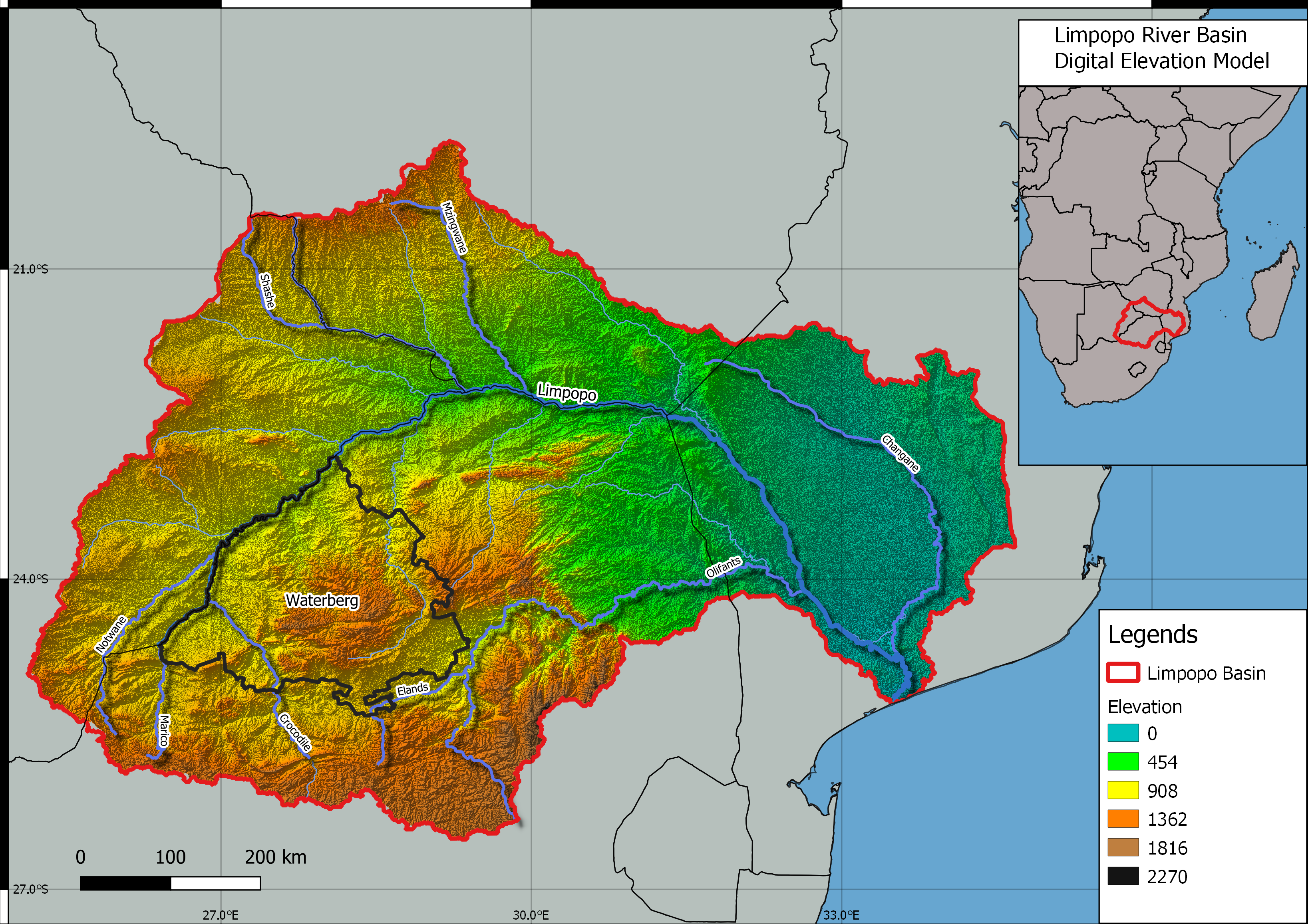
Figure 1: Limpopo River Basin: Location and Topography (Map by Juan Miguel Viquez & Daniel Knopp).
Soils
The soil classes across the Waterberg District are diverse. Major soils in the area are weakly developed soils on mountainous terrains, uplands, and surrounding rocky areas. Additionally, red-yellow Apedal, freely drained soils, and plinthic soils are common in the area (Department of Environmental Affairs, n.d.).
Weakly developed soils on mountainous catchments, uplands, and rocky areas occur in the central parts of the Waterberg District and extend eastwards. These kinds of soils are rocky, shallow, and acidic. As a result, the soil is rather unsuitable for farming. The red and yellow sandy soils are highly leached and tend to be acidic with low fertility. A suitable use for this soil is afforestation since its value as arable land is limited.
Natural Resources
Waterberg district's natural resources are of significant importance to South Africa since the region is one of the major mining regions. Primary resources are platinum, iron ore, coal, and diamonds. In addition, it is important to stress that 40% of the national coal reserves are located within the Waterberg District (Department of Cooperative Governance and Traditional Affairs, n.d.). At the same time, these natural resources create significant challenges for equitable and sustainable development in the region.
References:
De Klerk, A. (2003): The Waterberg Biosphere Reserve.
Department of Environmental Affairs (n.d.): Waterberg District Environmental Management Framework Report. Available at: https://www.dffe.gov.za/sites/default/files/docs/waterberg_finalreport.pdf
Department of Forestry, Fisheries and the Environment (n.d.): Environmental Management Framework for the Waterberg District. Status Quo Report. Available at: https://www.dffe.gov.za/sites/default/files/docs/waterberg_statusquo_finalreport.pdf
Department of Cooperative Governance and Traditional Affairs (n.d.): Waterberg Profile. Available at: https://www.cogta.gov.za/ddm/wp-content/uploads/2020/11/Take2_2020.06.15-WATERBERG-DISTRICT-PROFILE-Edited-Version-final_V1.pdf
Thabazimbi Local Municipality (2010): Investment and Marketing Strategy. Available at: http://www.thabazimbi.gov.za/documents/TLM%20INVESTMENT%20AND%20MARKETING%20STRATEGY.pdf.
Clark, V.R., Barker, N.P. & Mucina, L. (2011): The Great Escarpment of southern Africa: a new frontier for biodiversity exploration. Biodivers Conserv 20, 2543. https://doi.org/10.1007/s10531-011-0103-3