JÚCAR RIVER BASIN (SPAIN)
Natural Environment
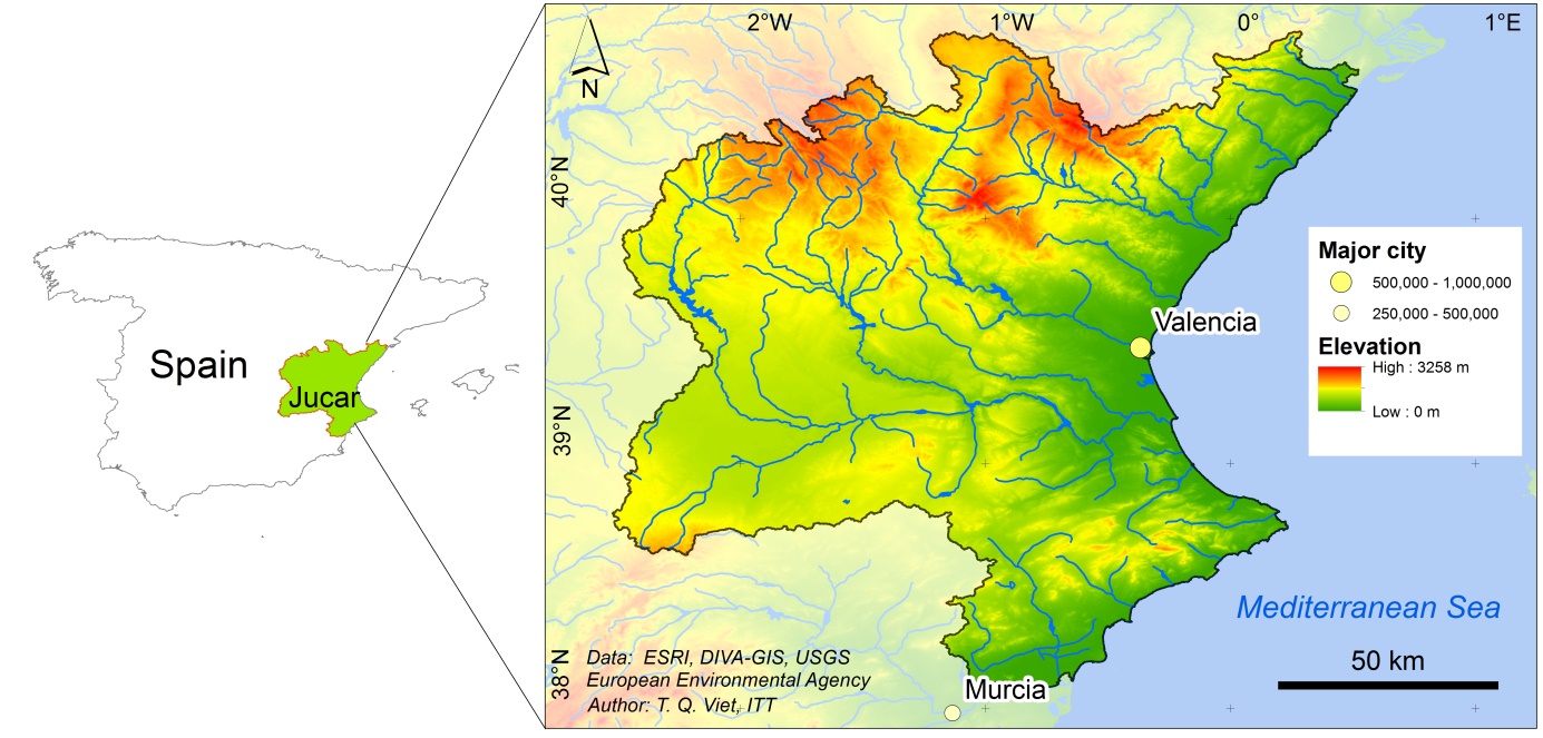
The JRBD comprises mountainous areas and a coastal zone characterized by lowlands. The coastal zones are known as “Planas” from which the most relevant are Oropesa-Torreblanca, Castellón-Sagunto, Valencia-La Ribera, and Favara-Gandía-Denia. The highest mount is Peñarroya, located in the Iberian System (described below) with an altitude of 2,024 m.
Soils
The territory of the Júcar region is characterized by a mesozoic cover which was formed in the formation period of the Alpes. Therefore, Neogene material is a special characteristic in this region. The soil in the region is sub-classified into Fluvisol, Cambrisol, Regosol, Acrisol, Gypsisol, Leptosol, and Cacisol.

Geomorphological characteristics
The mountainous chain system within the JRBD is called the Iberian System. The Iberian System acts like a barrier for the marine heads, forcing the humid clouds to rise to the highest atmospheric layers, and supports the precipitation in these mountainous regions.
The rivers Turia, Mijares and Júcar arise from the Montes Universales. These three river basins cover approximately two thirds of the whole JRBD. The mountain chain of the Betic System ends in the south-east of the region, where the rivers Serpis and Vinalopó arise. The coastal plain is a fluvial platform which is extended on the coastal borderline with the most fertile soil enabling agricultural activities to develop. More than 80% of the population is living in this region. The “Mancha” region is located in the east between the Iberian and Betic System. It is mostly flat with a maximum altitude of 650 m.
Other geomorphologically important areas are the wetlands and marshes: La Albufera de Valencia, Pego-Oliva, Cabanes-Torreblanca and Santa Pola. All them are located close to the coast, and play an important role from the environmental and socio-economic perspectives. Especially relevant is the Albufera which is included in the RAMSAR list, and classified as a Community interest area and Special Bird Protection Area.
References and further reading:
Andreu et al. (2009) Decision Support System for Drought Planning and Management in the Jucar River Basin, Spain.
Andreu et al. (2013) Drought Planning and Management in the Júcar River Basin, Spain, in: Schwabe et al., Drought in Arid and Semi-Arid Regions, Springer-Verlag Berlin Heidelberg, Germany.
Confederación Hidrográfica del Júcar, www.chj.es Júcar River Basin Agency: Jucar Pilot River Basin – Spain.
Momblanch A., Andreu J., Paredes-Arquiola J., Solera A., Pedro-Monzonís M. (2014) Adapting water accounting for integrated water resource management. The Júcar Water Resource System (Spain), Journal of Hydrology, 519: 3369-3385.
Paredes-Arquiola J., Andreu-Álvarez J., Martín-Monerris M., Solera A. (2010) Water quantity and quality models applied to the Jucar River Basin, Spain, Water Resource Management, 24: 2759-2779.
Pedro-Monzonís M., Ferrer J., Solera A., Estrela T., Paredes-Arquiola J. (2015) Key issues for determining the exploitable water resources in a Mediterranean river basin, Science of the Total Environment, 503-504: 319-28.