PARAÍBA DO SUL (BRAZIL)
Natural Environment
The Paraíba Do Sul (PDS) is denoted as one of the most important river basins of Brazil. Its waters are extensively used for domestic and industrial purposes as well as for irrigation systems and hydropower generation to supply the major urban areas of the country (Pinto et al., 2006).
The basin is located in southeast Brazil, covering an area of around 57´600 square kilometres. It is crossing the three federal states of Minas Gerais, Rio de Janeiro and São Paulo.
The high demand for water resources leads to water allocation problems in hydrological years with low rainfall. As well, the lack of an adequate water treatment after human consumption provokes water quality issues jeopardizing present ecosystems and human health (Freitas et al., 2007). In 2014, southeast Brazil was hit by a severe drought resulting into the aridification of dam reservoirs within the PDS (Howard, 2014). The domestic water supply of hundreds of cities, including the metropolitan areas of São Paulo and Rio de Janeiro, was threatened (Bowater, 2014). Controversial flow regulation of the dams led to a water conflict between Minas Gerais, Rio de Janeiro and São Paulo.
The existing pressures on water resources within one of the most relevant economic areas of Brazil in close vicinity to Brazils largest metropolitan regions comprise the main reasons for the selection of the PDS for this report.

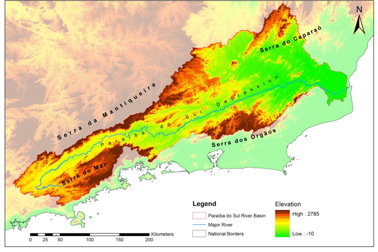
Topography
The PDS basin possesses a large range of height levels. The following figure shows a digital elevation model, including major geomorphological units. The highest elevation levels of up to 2785 metres are found in the Serra da Mantiqueira, which ascends abruptly from the northwest of the PDS. To the south, highest elevation levels are found in the Serra dos Órgãos and the Serra do Mar. A great part of the main river and its tributaries stretches along a depression between the predominant mountain ranges at heights ranging from 800 to 200 meters above sea level. The lower third of the basin is located in the east and characterized by wide regions with less than 200 metres above sea level.
Geology
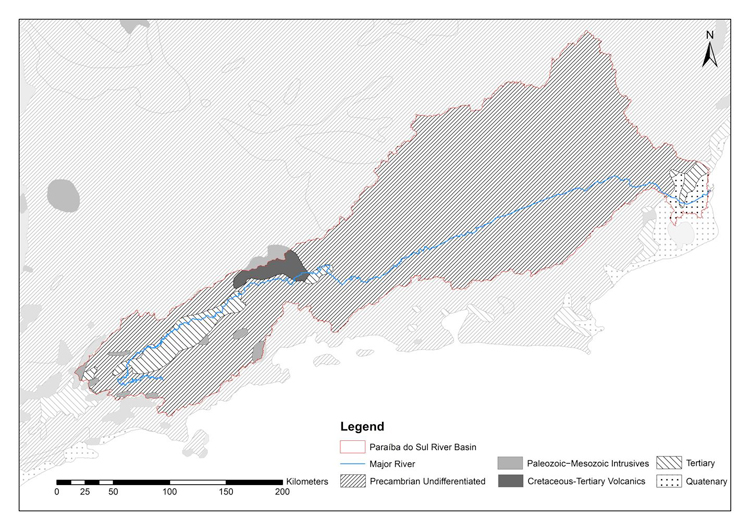
The PDS is located within the Brazilian Highlands, a continental shield of the South American Plate. It is part of the Highlands Atlantic Plateau, which is characterized by a Precambrian basement containing the oldest rock formations of the continent (Schobbenhaus & Brito Neves, 2003). The basement of the PDS has been formed during the era of the Neoproterozoic 1000 to 540 million years (CPRM, 2003). As opposed to the Andes, the continental shield is geological inactive today.
Precambrian rocks constitute more than 90 per cent of the total area. Granitoid gneisses, migmatites, biotite-gneiss and biotite schists are predominant (DNPM, 1983). Close to the outlet and along the depression zone of São Paulo tertiary rocks can be found. The upper basin is also home to small patches of Paleozoic-Mesozoic intrusives, as well as Cretaceous-Tertiary volcanics. Quartenary material is dominant at the outlet. The following figure provides a spatial overview.
Soils
Brazil has its own soil taxonomy, incorporating elements of the USDA and FAO soil classification (Jacomine et al., 2008-2009). The taxonomy comprises 6 different categorical levels. The first level includes 12 orders (soil types), of which six are found within the PDS.
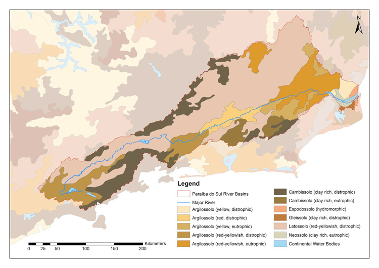
Latossolos (USDA = Oxisol) represent the major soil type within the basin. They stretch from the depression zone in the far west to the northeast of the Muriaé sub-basin. The Latossolos possess a red to yellowish colour due to high content of iron and aluminium oxides (EMPRABA, 2005-2011). In the PDS, the minerals are leached out due to the humid conditions throughout the year causing low fertility. Latossolos are clay rich, thus having a high potential of causing landslides on slopes in case of inappropriate land use practices.
Cambissolos (USDA = Cambisols) are dominant in the mountain regions of the Serra da Mantiqueira, Serra dos Órgãos and the Serra do Mar. They are undeveloped, not exceeding soil formation beyond a few metres. Cambisols are susceptible to erosion at slopes; usually acid and characterized by low soil fertility rates (EMPRABA, 2005-2011). However, base rich Cambisols marked by higher fertility levels are also present in the vicinity of the larger urban areas of Petrópolis, Teresópolis and Nova Friburgo.
The third soil type that is present over larger areas is the Argissol (USDA = Ultisol). In the slope regions of the upper and middle section of the basin, high acidity, high aluminium levels, high erosion potentials and low fertility rates characterize this type of soil (EMPRABA, 1999; EMPRABA, 2005-2011). However, in the smoother lowlands eutrophic Agrissolos with good physical conditions and greater agricultural potential can be identified. Close to the outlet small patches of Espodossolos (Podzols), Gleissolos (Gleysols) and Neossolos (Entisols) can be found.
Land cover/ Land use
The anthropogenic influence entirely transformed the natural vegetation cover of a forest landscape to a non-forest landscape (AGEVAP, 2006). Today, pasture areas are the prevalent land cover type throughout the basin (see table). The largest concentration of pastures and croplands is found along the plane area of the Paraíba do Sul depression and in the downstream sub-basins Muriaé and Pomba. In Minas Gerais more than 80 per cent of the total area is denoted as pasture. However, not necessarily all of these grazing areas are under effective use. Many pastureland are not being used due to environmental degradation by erosion (AGEVAP, 2006).
Table: PDS Land Use/ Land Cover in Percentage of State Area (Sirius, 2010-2014)
| Land Cover/Use | Minas Gerais (% of Area) | Rio de Janeiro (% of Area) |
São Paulo (% of Area) |
| Pasture | 80,2 | 61,2 | 57,6 |
| Secondary Vegetation | 9,2 | 17,8 | 12,3 |
| Forest | 5,2 | 13,2 | 15,6 |
| Agriculture | 2 | 2,4 | 4,5 |
| Reforestation | 0,5 | 0,4 | 4,4 |
| Urban Area | 0,4 | 1,1 | 2,6 |
| Water | 0,1 | 0,7 | 1,7 |
| Bare Soil | 0 | 0,3 | 0,1 |
On the contrary to other regions of Brazil, agriculture does only play a minor role. In all the three states the share is less than 5 per cent of the total area. The main cultivated crops are rice, beans, corn, potatoes, pears, lemons and oranges (SIRIUS, 2010-2014).
Although tree covered areas are still widespread over the entire basin, they are highly fragmented because of land clearings for pastures. Only along the steep slopes of the abruptly ascending mountain ranges, forest covered areas are found at one stretch due to their unsuitability for pastures. Connected forest cover patches mostly possess a protection status.
References and further reading:
AGEVAP (2006) Associação Pró-Gestão das Águas da Bacia Hidrográfica do Rio Paraíba do Sul, Plano de Recursos Hídricos da Bacia do Rio Paraíba do Sul – Resumo, http://www.ceivap.org.br/downloads/PSR-010-R0.pdf, accessed: 02.12.2014.
Bowater, D. (2014) Water war in Brazil as Rio's supply threatened, http://www.telegraph.co.uk/news/worldnews/southamerica/brazil/11033846/Water-war-in-Brazil-as-Rios-supply-threatened.html, accessed: 05.11.2014.
CPRM (2003) Geologia, Tectonica e Recursos Minerais do Brasil, Texto, Mapas & SIG, http://www.academia.edu/2311578/Geologia_Tectônica_e_Recursos_Minerais_do_Brasil_-_CPRM, accessed: 01.12.2014.
DNPM (1983) Departamento Nacional de Produção Mineral, Projeto RADAMBRASIL, Levantamento de Recurso Naturais 32, Folhas SF.23/24. Ministério de Minas e Energia, pp. 780.
EMPRABA (1999) Mapa de Solos. http://www.dpi.inpe.br/Ambdata/mapa_solos.php, accessed: 15.11.2012.
EMPRABA (2005-2011) Empresa Brasileira de Pesquisa Agropecuária, http://www.agencia.cnptia.embrapa.br/gestor/solos_tropicais/arvore/CONT000gn1sba0i02wx5ok0liq1mqkbnn5r8.html, accessed: 20.11.2014.
Freitas, C. M., Schütz, G. E., De Oliveira, S. G. (2007) Environmental sustainability and human well-being indicators from the ecosystem perspective in the Middle Paraíba Region, Rio de Janeiro State, Brazil, http://www.scielo.br/scielo.php?script=sci_arttext&pid=S0102-311X2007001600012, accessed: 01.12.2014.
Howard, B. C. (2014) Brazil's Severe Drought Dries Up Reservoirs. http://news.nationalgeographic.com/news/2014/10/141024-sao-paulo-brazil-drought-water-environment/, accessed 05.11.2014.
Pinto, B. C. T., Peixoto, M. G., Araújo, F. G. (2006) Effects of the proximity from an industrial plant on fish assemblages in the rio Paraíba do Sul, southeastern Brazil, http://www.scielo.br/scielo.php?pid=S1679-62252006000200013&script=sci_arttext, accessed: 29.11.2014.
Schobbenhaus, C., Brito Neves, B. B. (2003) A Geologia do Brasil no Contexto da Plataforma Sul-Americana, http://www.cprm.gov.br/publique/media/capI-a.pdf, accessed: 01.12.2014.
Sirius (2010-2014) Sustainable Irrigation Water Manangement and River-basin Governance, Paraíba do Sul, http://sirius-gmes.es/brazil/, accessed: 02.12.2014.