imperial river basiN (chile)
Natural Environment
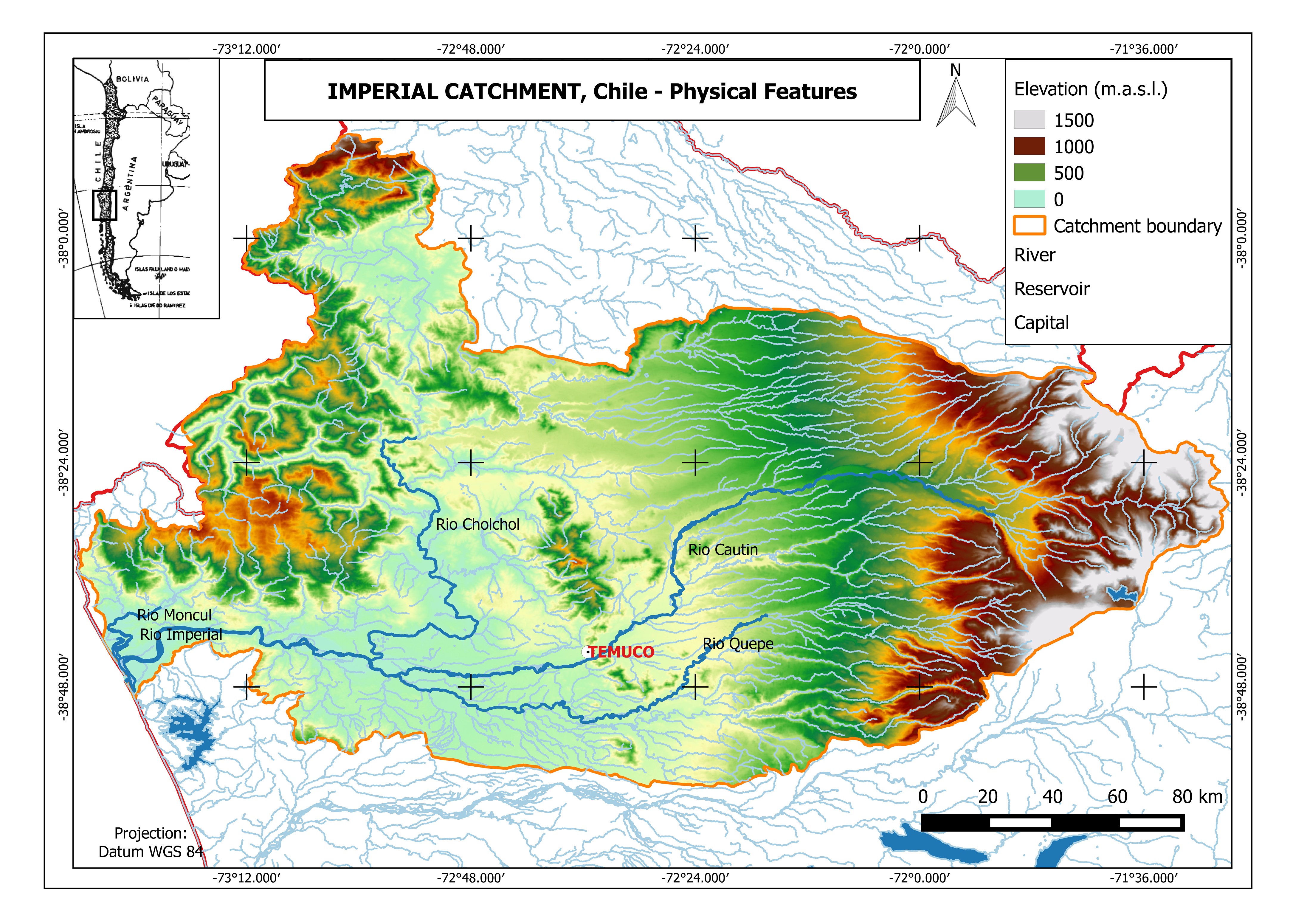
The Imperial River Basin is located between 37°51 and 38°56 latitude south, and its drainage area covers about 12 005 km2 in southern Chile (see Figure 1). The main water course is the Imperial River, which is formed by the confluence of the Cautín and CholChol rivers, with an average annual flow of 260 m3/s and 230 km from its head in the Andes mountain range to its mouth at the Pacific Ocean.
Geomorphology
The Imperial River Basin is a pre-Andean basin, where four formations are distinguished: The Andes Mountains, the Intermediate Depression, the Coastal or Nahuelbuta mountain range, and the Coastal Plains (CADE-IDEPE, 2004). The Andes mountains present an average height of 2 000 m a.s.l., with the highest elevations corresponding to the Llaima (3 124 m a.s.l.), Tolhuaca (2 789 m a.s.l.) and Lonquimay (2 822 m a.s.l.) volcanoes, and the Sierra Nevada (2 580 m a.s.l.) mountain range. Several smaller streams and lakes of various sizes complete the Andean relief, originated mainly by volcanic activity. The Intermediate Depression is characterized by plains and hills that generally do not exceed 300 m a.s.l. This plain is filled with fluvial, glacial and volcanic deposits which are evenly distributed. Slopes range from 0 up to 30%. The Nahuelbuta mountain range has a clear north-south orientation, and presents elevations that do not exceed 1 500 m a.s.l with gentle slopes (0-45%). Its main composition corresponds to metamorphic granitic material with important decomposition. Erosion in these areas is very intense, and therefore no original formations can be observed. Finally, the Coastal Plain corresponds to a strip of wavy and low-elevation relief, shaped by the abrasive action of the sea. Its composition corresponds mostly to fluvial and marine deposits (CADE-IDEPE, 2004).
Geology
As in much of the country, physiographic features of the area are conditioned by the existence of the Andes mountain range, the Intermediate Depression and the Coastal Mountains. However, forms of second order, as coastal and foothills plains, tend to complicate the relief pattern and reveal the influence of transitional conditions (CONIC-BF, 2010). The mountain range of the Araucanía Region is predominantly made up of volcanic rocks. These are flows of pyroclastic, rhyolite, dacite and basalt deposits associated with well-preserved ancient or active volcanoes. These mountains usually do not provide aquifer characteristics and present a very low permeability. The central valley is formed by unconsolidated deposits, with presence of fluvial, glacial, alluvial, lacustrine, and aeolian sediments. Aquifers in the valley have a variable length, are usually stratified, and generally they can be classified as free or semi-confined units. These aquifers have high to medium permeability and the chemical quality of the water is also variable. Finally, the coastal area is formed by metamorphic and sedimentary rocks, as sandstones, shales, phyllites, gneisses, amphibolites, lutites and quartzites. The soil in this area has a permeability close to zero with an impermeable basement (CONIC-BF, 2010).
Soil Types
The Imperial River Basin is characterized by the following soil types (CADE-IDEPE, 2004):
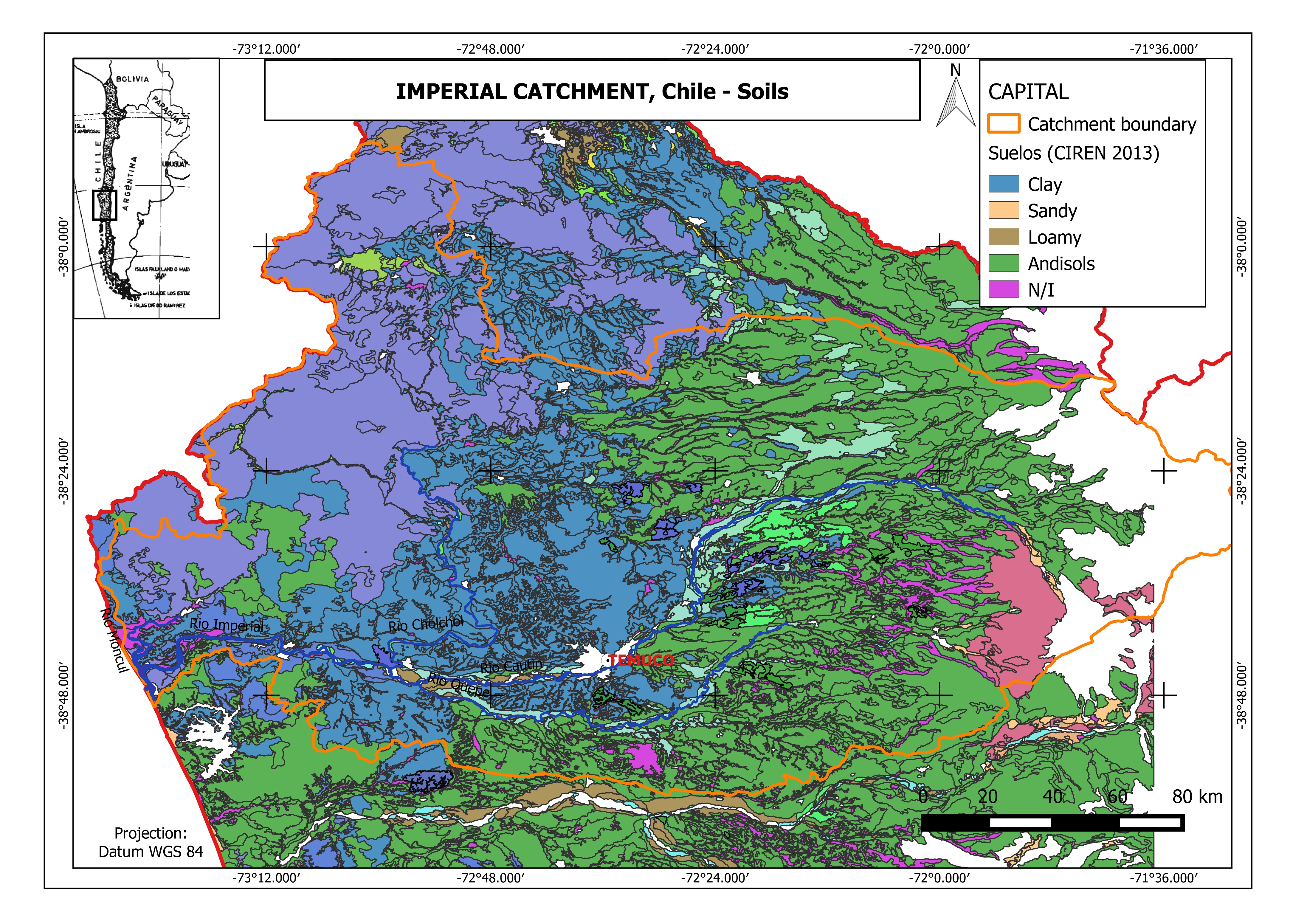
- Recent soils derived from volcanic sands: They are alluvial soils with thick textures throughout the profile, but it might be thinner on the surface. The topography is generally flat to gently undulating (1-3%). Soil depth generally exceeds 1 m and the substrate is constituted by sand or sand and gravel layers. They do not have a big susceptibility to deterioration effects that involve large earthmoving or erosion. This type of soil is found in the mouth area of the basin.
- Andisols (Trumaos): These soils are located in the Intermediate Depression, linked to a strong topography of low ridges and hills. They are generally deep soils, with average to moderately coarse textures throughout the profile. They have a high organic content (8-25%). Generally they do not offer limitations for construction of infrastructure. However, the hills and mountains present some problems related to erosion (proportional to the degree of slope and density of vegetation cover). Because of the high capacity of water retention, these soils can be subject to landslide.
- Red clay derived from volcanic materials: These soils are located in middle of the basin, usually they are deep and derived from various volcanic materials including volcanic ashes. The undulating topography is usually flat with some hills. They have a lot of crystalline kaolinite clay, and therefore infiltration and permeability are low, favouring surface runoff and erosion phenomena, especially in the absence of vegetation. They are sensitive to problems arising from the construction of infrastructure that involve the removal of vegetation cover, especially when the slopes are high, creating severe risks of water erosion.
- Metamorphic soils of hillsides and hills: This type of soil is found in the coastal area of the basin, with hillocks and hills, including the piedmont, with steep slopes that exceed 30%. The depth is usually higher than 1 m if the soil has not been eroded, but there are rocky outcrops. The textures are medium to moderately fine at the surface, with clayish textures in depth. Erosion problems are severe, with infrastructure works involving the removal of vegetation cover in the rainy season producing an immediate erosive effect.
- Alluvial clay soils: this type of soil is located on the Andean foothills. They are of alluvial origin, located in alluvial terraces and alluvial fans of great extension, their relief is flat to moderately flat, with dominant slopes of 0-1%. Usually their profile ranges from deep to moderately deep; with clay loam to clayey textures. Permeability is slow with restricted drainage, affecting some properties such as soil bearing capacity.
- Marine terraces from medium to fine-textured soils: These soils are located in the southern coastal area of the basin, with topography ranging from flat to slightly undulating due to strong dissection, being associated to the Coastal Mountains. The dominant surface texture is moderately fine. Generally, it exceeds 1 m depth, with good drainage and low permeability. The moderate erosion problems are severe, associated with the steep slopes.
Land Use
Information regarding land use in the basin is summarized in Table 1.
Table 1: Main Land uses in the Imperial River Basin.
| Land Use | Area | % of basin area |
| Native forest and mixed forest | 252,000 | 19.9 |
| Forest plantations | 160,000 | 12.6 |
| Prairie | 88,000 | 6.9 |
| Agricultural land and irrigated agriculture | 17,000 | 1.3 |
| Urban and industrial areas | 6,000 | 0.5 |
| Other uses1 | 747,000 | 58.8 |
1 Refers to the following uses: scrub, scrub - grassland, crop - pasture rotation, unrecognised areas, water bodies, snow - glaciers and wetlands (Source: MOP, 2004).
The main land uses within the basin correspond to native forest, agriculture, grassland, shrubland, and forest plantations. The total irrigated area in the region is around 70 000 ha, while the potential area for irrigation is 135 300 ha Quiroga1987. Nowadays, 90-95% of the agricultural lands belongs to small farmers, and 80% of the agricultural demand is not satisfied. In this context, the main objective of the regional authorities of the agricultural sector (SEREMI) is to transform rain-fed areas into irrigated ones, and to provide enough water to supply the increasing demand. In addition, recent effects of climate change (i.e., increase of temperature and decrease of precipitation amount) has made possible the emergence of vineyards and other crops than a couple of decades ago were unthinkable in this region.
On the other hand, there are 483 482 ha of exotic forest plantations in the region (monocultures), mainly Pinus radiata (53%) and species of Eucalyptus (44%, INFOR, 2015). Since 2008, the species leading the annual area of plantation is Eucalyptus, in detriment of the Pinus surface, reaching a total plantation rate of 19 thousand hectares per year (INFOR, 2014). It should be noted that scientific studies mention that Eucalyptus has the highest rate of water consumption between forest species (Scott/Prinsloo, 2008; Huber et al., 2010).
Between 1993 and 2007 a decrease of 116 830 ha of agricultural land, 63 467 ha of meadows and shrublands, and 39 827 of native forest was registered. In the same period, an increase of 220 854 ha in the area occupied by forest plantations took place. Land use changes are consistent with the results of the Census of Agriculture and Forestry (INE, 2007), indicating a conversion of agricultural land to forest plantations, affecting arable land and food security in the region.
References and further reading:
Banco Mundial (2011) Chile: Diagnóstico de la gestión de los recursos hídricos. Banco Mundial, Departamento de Medio Ambiente y Desarrollo Sostenible, Región para América Latina y el Caribe. Available on http://www.dga.cl/eventos/Diagnostico%20gestion%20de%20recursos% 20hidricos%20en%20Chile_Banco%20Mundial.pdf. [Accessed on Jun 10th 2016].
CADE-IDEPE (2004) Diagnóstico y Clasificación de los Cursos y Cuerpos de Agua Según Objetivos de Calidad. Cuenca del Río Imperial. Technical Report. Ministerio de Obras Públicas, Dirección General de Aguas. Elaborado por: Cade-Idepe Consultores en Ingeniería. Available on http://www.sinia.cl/1292/articles-31018_Imperial.pdf.
CONIC-BF (2010) Mejoramiento y ampliación red de aguas subterráneas regiones VII a X. Informe Final. Ministerio de Obras Públicas, Dirección General de Aguas, División de Estudios y Planificación. Elaborado por: CONIC-BF Ingenieros Civiles Consultores.
CR2 (2015) Informe a la Nación: La Megasequía. Centro de Ciencia del Clima y la Resiliencia (CR2), Universidad de Chile. Available on http://www.uchile.cl/publicaciones/117420/informe-a-la-nacion-la-megasequia-2010-2015. [Accessed on Jun 10th, 2016].
DMC (2015) Descripción Climatológica Región de la Araucanía. Dirección Meteorológica de Chile (DMC). Available on http://www.meteochile. cl/climas/climas_novena_region.html. [Accessed on Dec 10th 2015].
Huber, A., Iroumé, A., Bathurst, J. (2008) Effect of Pinus radiata plantations on water balance in Chile. Hydrological Processes 22, 142–148. doi:10. 1002/hyp.6582.
Huber, A., Iroumé, A., Mohr, C., Frêne, C. (2010) Efecto de plantaciones de Pinus radiata y Eucalyptus globulus sobre el recurso agua en la Cordillera de la Costa de la región del Bíobío, Chile. Bosque (Valdivia) 31, 219–230. doi:10.4067/S0717-92002010000300006.
Huber J, A., Trecaman V, R. (2000) Efecto de una plantacin de Pinus radiata en la distribucin espacial del contenido de agua del suelo. Bosque (Valdivia) 21, 37–44.
Huber J, A., Trecaman V, R. (2004) Eficiencia del uso del agua en plantaciones de Pinus radiata en Chile. Bosque (Valdivia) 25, 33–43. doi:10.4067/S0717-92002004000300004.
INE (2007) Censo Agropecuario 2007. Instituto Nacional de Estadísticas (INE). Available on http://www.ine.cl/canales/chile_ estadistico/censos_agropecuarios/censo_agropecuario_07.php. [Accessed on Jun 10th 2016].
INE (2015) Compendio Estadístico-Región de la Araucanía 2015.Instituto Nacional de Estadística (INE). Dirección Regional de la Araucanía. Temuco, Chile. Available on http://www.inearaucania.cl/archivos/files/pdf/SistemaEstadisticoRegional/Compendio%20Estad%C3%ADstico% 20Regional%202015%20-%20La%20Araucan%C3%ADa.pdf. [Accessed on Jun 10th 2016].
INFOR (2014) Antecedentes Generales y Recurso Forestal Región de la Araucanía 2014. Instituto Forestal (INFOR). Available on http://wef.infor.cl/estadisticas_regionales/estadisticasregionales.php. [Accessed on Jun10th 2016].
INFOR (2015) El sector forestal chileno 2015. Instituto Forestal (INFOR). Available on http://wef.infor.cl/sector_forestal/ sectorforestal.php#/44. [Accessed on Jun 10th 2016].
Little, C., Lara, A., McPhee, J., Urrutia, R. (2009) Revealing the impact of forest exotic plantations on water yield in large scale watersheds in South-Central Chile. Journal of Hydrology 374, 162–170. doi:10.1016/ j.jhydrol.2009.06.011.
MOP (2012) Plan Regional de Infraestructura y Gestión del Recurso Hídrico al 2021. Resumen Ejecutivo. Ministerio de Obras Públicas, Región de la Araucanía. Available on http://www.dirplan.cl/planes/regional/ download/PRIGRH_Region_Araucania.pdf. [Accessed on Jun 10th 2016].
Quiroga, T.G. (1987) Investigación tecnológica de Riego. Instituto de Investigaciones Agropecuarias (Chile). Estación experimental Carillanca. Programa Riego y Drenaje. Temuco. Informe Final. p 12.
Scott, D.F., Prinsloo, F.W. (2008) Longer-term effects of pine and eucalypt plantations on streamflow. Water Resources Research, 44, W00A08. doi:10.1029/2007WR006781.
Sobarzo, C.T. (2014) Adaptación al cambio climático de la gestión hídrica. Master’s thesis. Magster en Gestión y Polticas Públicas. Universidad de Chile. Estudios de Caso Nro 129.