Huasco River Basin (Chile)
Natural Environment
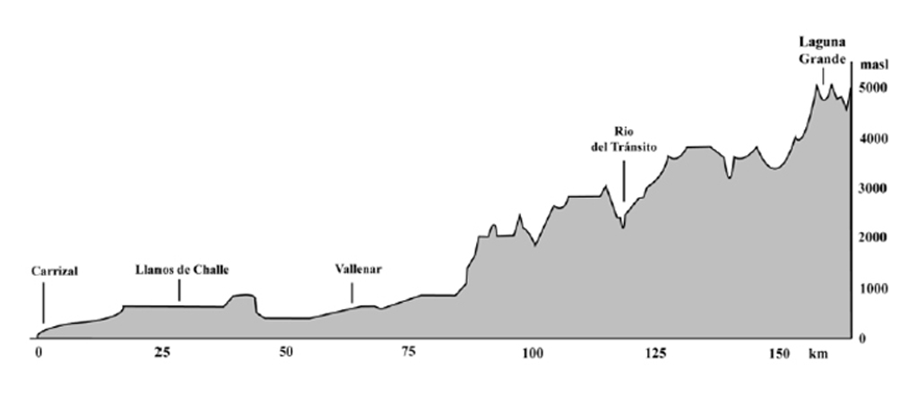
The Huasco watershed is located between 28°27’S to 29°33’W and 71°11’S to 69°56’W in the Atacama region (III Región), also called the Small North (“norte chico”) of Chile. With an extension of 9.850 km² it represents 1.3% of national Chilean territory. The Huasco River (2.825 km²), shows a discharge of 5.7 m³/s at Algodones (shortly after Alto del Carmen). Before it drains into the Pacific Ocean, it creates a coastal wetland of 2.187 hectares near the town of Huasco (DGA, 2004). The river has two main tributaries (Fundacion Chile, 2011):
- The Tránsito River (4.135 km²), 108 km long, drains the northern side of the high mountains of the basin, with a discharge of 2,02 m³/s at its confluence.
- The Carmen River (2.890 km²), 145 km long, drains the southern side of the high mountains of the basin, showing a discharge of 1,52 m³/s at its confluence.
The main water-structure of the basin is Santa Juana Dam, which was built in 1995 and has a storage capacity of approximately 170 million m³, responsible for securing water supply for the towns of Vallenar, Freirina and Huasco.

Soils and Topography
The pre-Andean mountain range is characterized by xerosols, calcisols and litosols. Towards the valley and the lower parts (city of Vallenar to the coast), the majority of soils show a topography of plain terraces including light slopes and normal drainages (DGA, 2004). Furthermore, they are rich in calcium, and moderate to scarce in organic materials, loose-textured and generally loamy to sandy (Núnez & Cortés, 2011).
The surface distribution of soil textures in the valley shows extraordinary opportunities for fruit production (60% loamy sand). One major problem is salinization, which caused by over-extraction and poor water quality experienced from Freirina to the coast (Fernández et al., 2008).
Vegetation
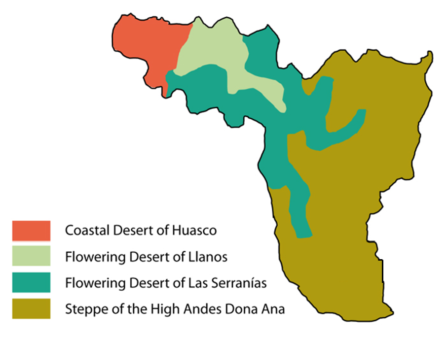
The Huasco Valley is mainly characterized by steppe vegetation with dry shrubs of sparse distribution. Influenced by the regional climatic and topographic conditions, the whole Atacama region shows high variability in its spatial distribution of vegetation zones. Four zones are dominant:
• Steppe of the High-Andes: High-mountain tundra with very low temperatures and relatively high precipitations.
• Flowering desert of Las Serranías: Cold desert-mountain climate with clear skies, low temperatures and relatively high precipitation.
• Flowering desert of Llanos: High temperatures, low precipitation and plain sandy terraces.
• Coastal-Desert of Huasco: Frequent fog intrusion, low precipitation.
References and further reading:
Agrosuper (2006) Declaracion de Impacto Ambiental - Modificación Proyecto Agroindustrial del Valle del Huasco: Planta Rendering, Planta, Vallenar.
Aguilera, G., Pouilly, M. (2011) Iniciativa Agua y la Naturaleza (WANI), Vallenar, Huasco, Chile
Bitar, S., Weisner, R., Atenas, M., Musalem, M., Zenteno, P., López, A., Mardones, C., et al. (2009) Análisis de Impacto Económico y Social de Anteproyecto de Normas Secundarias de Calidad - Cuenca Río Huasco, Santiago.
Cepeda, J., Fiebig, M., Morales, H., Salas, S. (2004) Description of the Elqui River Basin, La Serena.
DGA (2004) Cuenca del Rio Huasco: Diagnostico y clasificacion de los cursos y cuerpos de agua segun objectivos de calidad, p. 105.
Fernández, J., Novoa, E., Córdova, A., Salvatierra, A., Sierra, C., Vásquez, C., Jimena, C., et al. (2008) Caracterización Textural de Suelos: Valle del Río Huasco, La Serena.
Gonzáles Aravena, V. (2011) Embalse Santa Juana y la Administración de las Aguas de la Cuenca del Río Huasco, Vallenar.
NSW (2010) Returning environmental flows to the Snowy River: An overview of water recovery, management and delivery of increased flows, Office, Sydney.
Núnez, J., Cortés, A. (2011) Modelo Para la Gestion Hidrica e la Cuenca de Huasco: Evaluacion de Caudal Ambiental y Valoracion de Servicios Hidrologicos, La Serena, Chile.
Núñez, J., Soto, G., Guitierrez, S., Barrera Martínez, L., Pizarro, I., & Wagnitz, P. (2012) Proyecto Desarrollo de un Modelo Para La Gestión Hídrica Sustentable del Valle del Huasco, Mediante la Evaluación de Caudales Ambientales y la Valoración Económica-Social de los Servicios Hidrológicos, Informe Final, La Serena, Chile.
Pizarro Barraza, I. (2012) Geomorfologia Cuenca Huasco, La Serena.
Pouilly, M., Aguilera, G. (2012) Evaluación preliminar de caudales ecológicos en la cuenca del río Huasco (Chile) mediante la simulación del hábitat físico del pejerrey Basilichthys microlepidotus y el camarón de río Cryphiops caementarius, Paris.
Pti (2010) Agricultura en el valle del huasco, Vallenar.
Pti-CORFO (2008) Plan Terretorial Estratégico en el àmbito Productivo en la Provincia de Huasco: Informe Final, Vallenar.
Stehr, D., Álvarez, G., Chávez, A., Isensee, P., Canepa, B., Acevedo, J., Bórques, M., et al. (2006) Aplicación de Metodologías para Determinar la Eficiencia de Uso del Agua: Estudio de Caso en la Región de Coquimbo, Coquimbo: Gobierno Regional - Region de Coquimbo.
Wagnitz, P. (2012) Cost-benefit analysis regarding environmental flow implementation in the semi-arid Huasco watershed, northern Chile, La Serena.