
LIMARÍ (CHILE)
Natural Environment
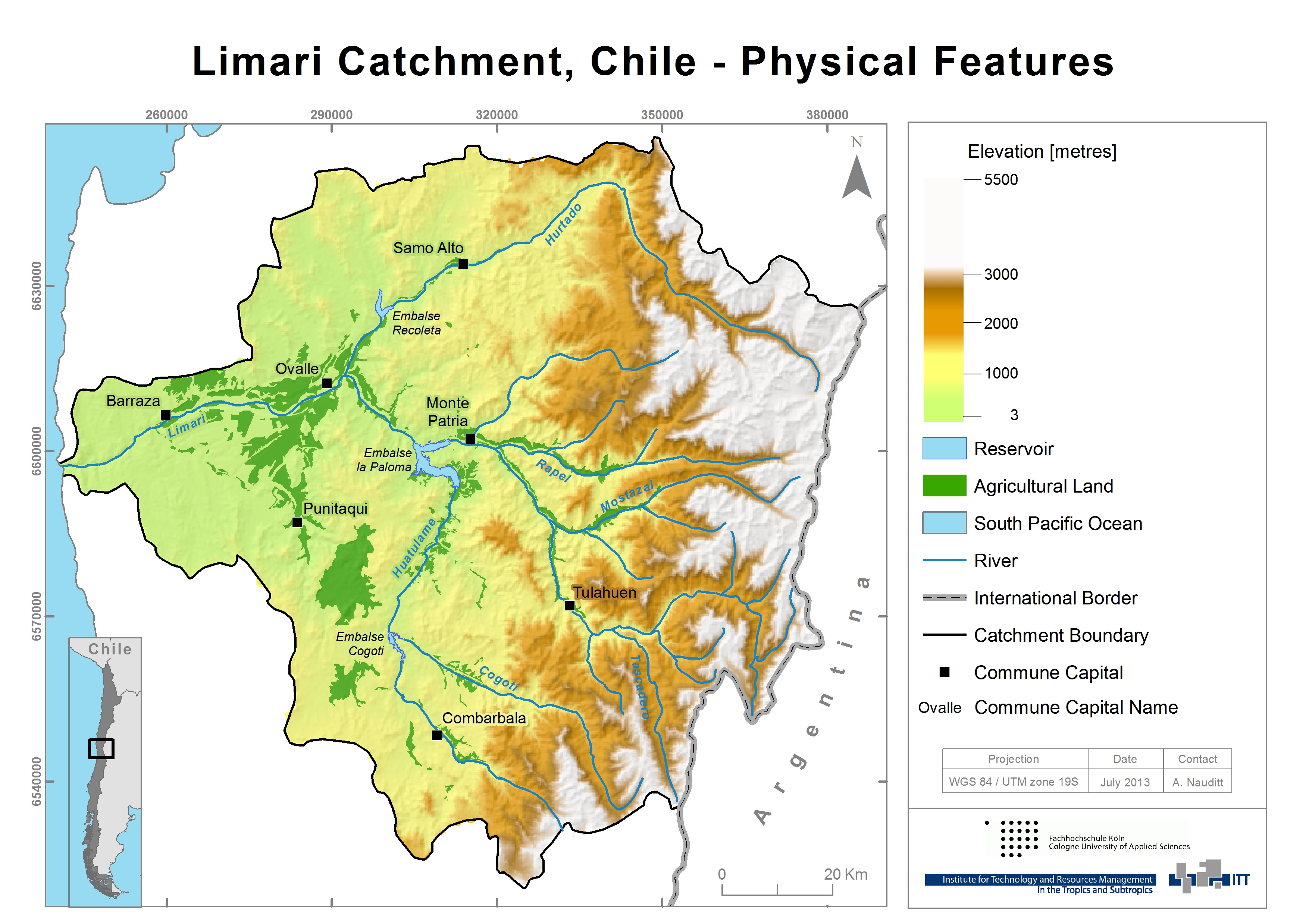
The Central Chilean semi-arid Limarí River Basin is located at the latitude of 30º 15’ to 31º 30’ S and longitude between 70º 15’ and 71º 45’ W and covers an area of 11.696 km². The basin is situated between the valleys of the Elqui basin in the North and the Choapa basin in the South and reaches from the Andes at >5500masl in the East to the coast of the Pacific Ocean in the West. The following map illustrates topography, agricultural land use and hydrology in the Limarí basin:
GEOMORPHOLOGY
Regarding the geomorphology, the basin can be characterized by the main landforms of the High Andean Mountain, the Middle Height Mountains, the Transverse Fluvial Valleys and the Coastal Stripe.
The High Mountains are corresponding to the mountain range of the Andes. Its summits overcome 3.500 meter above sea level, reaching on the Chilean-Argentine border at almost 6.000 masl. The Middle Height Mountains groups all those reliefs which height does not overcome 3.000 masl and it is separated from the Mountain range of the Andes by the fault of Vicuña. It appears like a relief dismembered and discontinuous, subject to the intense fluvial dissection. The Transverse Fluvial Valleys are characterized for presenting a complete system of terraces that correspond to the surfaces of marine sedimentation. And the coastal stripe described the area where the domain of marine terraces sedimentation starts. “Los Altos de Talinay”, a part of the coastal geomorphological structure, presents a set of platforms of marine abrasion that are correlated to the levels of sedimentation of the bays of Coquimbo and Tongoy.
GEOLOGY
The geology of the Limarí basin consists of a variety of rock formations ranging in age from Palaeozoic to Quaternary. The cordillera comprises the volcanic series of the Dona Ana Formation (Upper Oligocene-Lower Miocene). Unlike other parts of the Andes, there is no quaternary volcanism in the Coquimbo region. Nevertheless, in tectonic terms, two major phases are identified as Jurassic to lower Cretaceous (Marianas extensive type) and upper Cretaceous (Andean compressive type) (Oyarzún, 2008). The region hosts also one of the largest precious metal deposits, leading to an extensive mining exploitation. The coastal range primarily consists of Mesozoic intermediate calc‐alkaline rocks alternating with andesitic volcanic rocks. Quaternary alluvial sediments are concentrated in the river beds in the lower part of the catchments (Strauch et al., 2009; Oyarzún, 2010).
SOILS
Scarce information on soils is available for the region, especially above the cultivated areas. The entire region could be roughly divided into the coastal region and the upper Andean zone. In the coastal zone, alluvial clay rich fertile soils are found on marine terraces whereas Luvisols and Calcisols dominate in the valleys evolved from both marine and continental young sediments. Calcisols are common in arid and semiarid areas with calcareous parent materials (DGA, 2004; INIA, 2009). In the upper Andean area, where our pilot subcatchment is located, eutric and dystric Leptosols are dominating. These are very shallow unfertile soils over hard rock common in steppe landscapes in mountainous regions and are not appropriate for arable cropping (FAO, 2002; DGA, 2004). The following photograph shows the upper mountainous region at around 1000m of elevation.
Recently a study of CIREN has been released (CIREN, 2012), about the soils of the cultivated area in the region. It is an update of CIREN (1994) and also contains some geographic information.
LANDUSE
A detailed land use and vegetation classification map is missing for the region. The dominant vegetation is “Matorral”, steppe, mainly presenting bushes of sparse distribution on bare ground. Agriculture is found mainly in the valleys and flood plains of the lower areas.
The following map shows the land cover in the Limarí according to a DGA source cited by Oyarzún (2010):
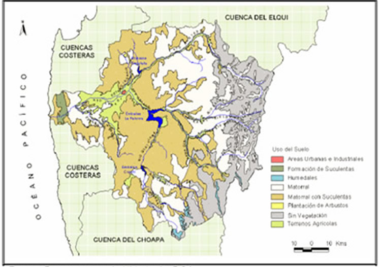
This map describes the main land cover types of the region. The brown surface represents “Matorral con Suculentas”, a sparse shrub vegetation with cacti on bare ground, which can be referred to as steppe. The light green corresponds to agricultural land, the white areas to arid mountainous “Matorral”, sparse bush vegetation, while the grey surface corresponds to rocks without vegetation.
In regard to the agricultural use, following land use characteristics can be described: the Limarí province is an important producer of high value wine grapes and table grapes. Citrus fruits, avocados and table grapes represent 34% of the cultivated area, annual crops to 24.5 % and wine to 21.5 % (Parga et al., 2005). The climatic conditions are especially favorable for the cultivation of mandarins in the Limarí Valley, which now contributes with 70% to the national production of mandarins (INIA, 2009). The total cultivated area has increased significantly since the construction of the Paloma reservoir system in 1973. Nowadays agricultural land covers an area of up to more than 62.000ha (Oyarzún, 2010). However more impressing than the total agricultural area is the change in crop types. The composition of crops has changed significantly from a large portion of annual plants as cereals to vineyards and fruit tree plantations as well as forage (Oyarzún, 2010). The extension of perennial plant types in the Limarí Valley is one of the main reasons why the permanent water demand in this area is increasing.
References and further reading:
Álvarez, P., Kretschmer, N., Oyarzún, R. (2006) Water Management for Irrigation in Chile: Causes and Consequences, paper presented at the international water fair Wasser Berlin 2006.
Ciren (1994) Estudio Agrológico de los valles de Choapa, Illapel y Limarí, Centro de Información de Recursos Naturales.
Ciren (2012) Describciones de suelos, Materiales y Simbolos, Publicación CIREN no. 129, Propiedad Intelectual N°151.231, ISBN956-7153-65-5, Esta edición complementa la cartografía digital de suelos, actualizada sobre 215 ortoimágenes satelitales año 2010-2011 en escala de salida 1:10.000 (the map in the annex shows the area of study).
DGA (2004) Diagnóstico y Clasificación de los Cursos y Cuerpos de Agua según Objetivos de Calidad. Cuenca del Río Limarí, Elaborado por CADE‐IDEPE Consultores en Ingeniería.
FAO (2002) Digital Soil Map of the World and derived soil properties, Land and Water Digital Media Series #1 rev 1. FAO, Rome.
INE (2007) Censo Agropecuario (2007), www.inecoquimbo.cl, accessed: 18.04.2012.
INIA (2009) Tierra adentro, frutales y viñas, Valle del Limarí, un aporte a la fruticultura chilena, http://www.inia.cl/link.cgi/; accessed: 12.03.2012.
Oyarzún, R., Arumí, J. L., Álvarez, P., Rivera, D. (2008) Water use in the Chilean agriculture: current situation and areas for research development, Sorensen ML (ed) Agricultural water management trends, Nova Publishers, New York, 213-236.
Oyarzún, R. (2010) Estudio de caso: Cuenca del Limarí, Región de Coquimbo, Chile, Compilación Resumida de Antecedentes, Centro de Estudios Avanzados en Zonas Aridas- Universidad de la Serena (CEAZA-ULS).
Parga, F., León, A., Vargas, X., Fuster, Y. (2006) El índice de pobreza hídrica aplicado a la cuenca del río Limarí en Chile semiárido, Eval. Usos del Agua en Tierras Secas de Iberoamérica, 12: 93-109.
Strauch, G., Oyarzún, R., Reinstorf, F., Oyarzún, J., Schirmer, M., Knöller, K. (2009) Interaction of water components in the semi-arid Huasco and Limarí river basins, North Central Chile, Advances in Geosciences, 22, 51–57.
LIMARÍ (CHILE)
Climate
The semi-arid Limarí River Basin, located in the Region of Coquimbo is bounded by the Pacific Ocean and the high Andes. The area’s climate records show vast spatial, intra- and inter-annual climate variations. Mean annual precipitation has a strong geographical modulation, ranging between approx. 43 and 270 mm per year from the coastal area to the Andes, with an average of only 125.7 mm (Oyarzún, 2010; Verbist et al., 2010).

The seasonal cycle of rainfall is well pronounced, as almost 85% of annual precipitation falls between May and June (Souvignet et al., 2010). Extended dry spells are a common feature and dry periods without precipitation may last from one up to multi-years (Favier et al., 2009). This inter-annual variability of rainfall is linked to ENSO (El Niño Southern Oscillation), with often positive rainfall anomalies during El Niño events and below normal rainfall during La Niña conditions (Verbist et al., 2010). This frequently causes a natural shortage of water availability, leading to meteorological droughts.
Temperature also displays a strong seasonality. Minimum temperatures occur in June-August, coinciding with precipitation maximums and hence snowfall above 1000m of elevation. The central climate station in Ovalle between 1965-2009 recorded a mean annual temperature of 16,6 °C with a minimum of 9, 4°C and a maximum of 23,8°C. Furthermore, spatial temperature variation is strong depending on elevation and the South-North gradient.
THE ENSO PHENOMENON AND ITS IMPACT ON CLIMATE VARIABILITY IN CENTRAL CHILE
The El Niño–Southern Oscillation (ENSO) is a well-known phenomenon in dry Central Chile. The irregular – every 2-7 years – El Niño and La Niña years originate in the tropical Pacific and are accompanied by interactions between the ocean and the atmosphere and teleconnections over the tropical Indian and Pacific Oceans. They have clear signals in sea surface temperature (SST), atmospheric pressure patterns and a varying strength of the Pacific trade winds.
While El Niño years account for higher sea surface temperatures and lower air pressure in the Eastern Pacific, La Niña conditions are generated by cold sea surface temperatures originating in the tropical Pacific (Mc Phaden et al., 2006; Tudhope et al., 2001). Higher El Niño SSTs lead to higher evaporation rates and hence to above-average rainfall in the eastern Pacific and Central Chile during winter and late spring. At the same time, it causes severe droughts in eastern Australia and storms along the equator. Measuring sea surface temperature and atmospheric pressure enables the prediction of El Niño and la Niña events more than several months ahead (Montecinos & Aceituno, 2003). On the other hand, La Niña years lead to dry conditions in Central Chile in winter and late spring. However, there is no reliable correlation between the ENSO index value and precipitation rates.
It is believed that ENSO is sensitive to global warming. Tudhope et al. (2001) analyzed annually banded corals from Papua New Guinea to determine how ENSO has varied in response to both glacial and interglacial conditions during the past 130,000 years. They have found that in the past century, the ENSO signals have been stronger than during the seven earlier cool (glacial) and warm (interglacial) periods analyzed and they suggest that this change might be due to glacial retreat and solar forcing (Tudhope et al., 2001). Gomez et al. (2011) conducted a further paleoclimatic analysis of high-resolution Lake Tutira storm sediment records for the past 6800 years and derived historical rainfall events indicating ENSO patterns with teleconnections to records from New Zealand, the tropical Pacific and Antarctica. They also suggest that solar radiation strength plays a crucial role and therefore might be the reason for the accelerated ENSO cycle during the recent decades (Gomez et al., 2011).
References and further reading:
Álvarez, P., Kretschmer, N., Oyarzún, R. (2006) Water Management for Irrigation in Chile: Causes and Consequences, paper presented at the international water fair “Wasser Berlin 2006”.
Favier, V., Falvey, M., Rabatel, A., Praderio, E., López, D. (2009) Interpreting discrepancies between discharge and precipitation in high-altitude area of Chile’s Norte Chico region (26–32°S), Water Resources Research, 45, W02424, doi:10.1029/2008WR006802.
Gomez, B., Carter, L., Orpin, A. R., Cobb, K. M., Page, M. J., Trustrum, N. A., Palmer, A. S. (2011): ENSO/SAM interactions during the middle and late Holocene, The Holocene, DOI: 10.1177/0959683611405241.
McPhaden, M. J., Zebiak, S. E., Glantz, M. H. (2006) ENSO as an Integrating Concept in Earth Science, Science 15 December 2006: 314 (5806), 1740-1745, DOI:10.1126/science.1132588.
Montecinos, A., Aceituno, P. (2003) Seasonality of the ENSO-related rainfall variability in central Chile and associated circulation anomalies, Journal of Climate, 16, 281-296.
Oyarzún, R. (2010) Estudio de caso: Cuenca del Limarí, Región de Coquimbo, Chile, Compilación Resumida de Antecedentes, Centro de Estudios Avanzados en Zonas Aridas- Universidad de la Serena (CEAZA-ULS).
Parga, F., León, A., Vargas, X., Fuster, R. (2005) El índice de pobreza hídrica aplicado a la cuenca del Río Limarí en Chile semiárido, volumen XI, El Agua en Iberoamérica en 2005, http://www.cricyt.edu.ar/ladyot/publicaciones/cyted_libro_XII/articulos/093.pdf on the 15th of August 2011.
Peel, M. C., Finalyson, B. L., Mc Mahon, T. A. (2007) Updated World Map of the Köppen‐Geiger Climate Classification. Hydrology and Earth System Sciences, 11(5): 1633‐1644.
Souvignet, M., Gaese, H., Ribbe, L., Kretschmer, N., Oyarzún, R. (2010) Statistical downscaling of precipitation and temperature in north-central Chile: an assessment of possible climate change impacts in an arid Andean watershed, Hydrological Sciences Journal, 55(1), 41-57.
Tudhope, A. W., Chilcott, C. P., Mc Culloch, M. T., Cook, E. R., Chappell, J., Ellam, R. M., Lea, D. W., Lough, J. M., Shimmield, G. B. (2001) Variability in the El Niño Southern Oscillation Through a Glacial-Interglacial Cycle, Science, 291, 23.
Verbist, K., Robertson, A. W., Cornelis, W., Gabriels, D. (2010) Seasonal predictability of daily rainfall characteristics in central-northern Chile for dry-land management, Journal for Applied Meteorology and Climate, 49(9), 1938-1955.
VicuñA, S., Garreaud, R. D., McPhee, J. (2010) Climate change impacts on the hydrology of a snowmelt driven basin in semiarid Chile, Climatic Change, 105(3-4), 469-488.
LIMARÍ (CHILE)
Socioeconomic development
The Limarí River Basin covers almost the entire Limarí Province and belongs to the Coquimbo Region (IV. Región, El Norte Chico). Until the mid-1990s, the IVth Region of Coquimbo and the Limarí River Basin belonged to the poorest areas of Chile with 30% of the population living below the poverty line (Leon & Garay, 2005). The construction of an interconnected three reservoir system, initiated back in the 1920s and completed in 1967 (MOP, 1978) had the aim to increase the agricultural output and to strengthen the regional economy. Since the construction of the Paloma system reservoir with a storage capacity of 1,000 hm³ (INIA, 2009), the cultivated area has increased significantly and improved the incomes of the local population. 48% of the agricultural surface in the whole Coquimbo region is cultivated in the Limarí Valley and irrigated agriculture is the foremost employment opportunity (Soto, 2000).
Nowadays, the Limarí river basin is an intensively used agricultural zone with heterogeneous crop mix of vegetable, grain, wheat, cereals and meat. Citrus fruits, avocados and table grapes represent 34% of the cultivated area, annual crops 24.5 % and wine 21.5 % (Parga et al., 2005). The climatic conditions are especially favorable for the cultivation of mandarins and the Limarí Valley contributes with 70% to the national production of mandarins (INIA, 2009). High value wine grapes, table grapes, avocado or lemons that profit from the off-season in the northern hemisphere are exported to the U.S.A., the European Union, and Asia. Over 70% of the regional export is produced in the Limari-Basin (Oyarzún, 2010). The types of agriculture regimes range from medium-sized farms to large-scale multinational private holdings. Larger producers are mainly oriented on irrigated crop production for the international market.
The adoption of the neo-liberal economic model in Chile in the early 1980’s has led to major changes in the land and water property rights in the country. During the economic liberalization the ‘National Water Code’ has been established. The Water Code of 1981 determines that water is a national resource for private use and allows private transferable property rights (Bauer, 1997). Before implementing the Code, water resources were state owned. Water management in this region is managed by the Water User Associations, whose members are famers of the region. The monitoring boards (Juntas de Vigilancia) are responsible for the control of the natural river courses, while the associations take the responsibility of the canals. The organizations manage the distribution and the infrastructure of water.
As socio-economic development in the Limarí area is highly connected to irrigation water, changes in the flow regimes affect the agricultural productivity. Less runoff provides less water for irrigation. Recently, the area has been subject to severe droughts (León, 2005). The precipitation has decreased over the last years, so that long-term irrigation policies had high impact on the society. Therefore, water availability is the most important concern and it is in Chile´s interest to develop strategies to improve the efficient use.
The following map shows the study region illustrating topography, hydrology with reservoirs, human settlements, agricultural area and administrative boundaries:

References and further reading:
Bauer, C. (1997) Bringing Water Markets Down to Earth: The Political Economy of Water Rights in Chile, 1976-95, World Development, 25(5), 639-656.
INIA (2009) Tierra adentro, frutales y viñas, Valle del Limarí, un aporte a la fruticultura chilena, http://www.inia.cl/link.cgi/; accessed: 12.03.2012.
León, A., Montana, E., Fuster, R. (2002) Riego y pobreza rural: dos estudios de caso en la región semiárida de Chile y Argentina: la comparación de dos cuencas hidrográficas en Chile y Argentina, Eval. Usos del Agua en Tierras Secas de Iberoamérica 12, 65–92.
León, A., Garay-Flühmann, R. (2005) Public policy as a means to increase human security in agriculture in a drought-prone area of northern Chile, Department of Environmental Sciences and Renewable Natural Resources, Faculty of Agricultural Sciences, University of Chile, Human Security and Climate Change, An International Workshop, Holmen Fjord Hotel, Asker, near Oslo, 22–23 June 2005.
MOP (Ministerio de Obras Públicas) (1978) Annual Reports 1887/1977 1888/1978, Santiago,Chile.
Oyarzún, R. (2010) Estudio de caso: Cuenca del Limarí, Región de Coquimbo, Chile, Compilación Resumida de Antecedentes, Centro de Estudios Avanzados en Zonas Aridas- Universidad de la Serena (CEAZA-ULS).
Parga, F., León, A., Vargas, X., Fuster, R. (2005) El índice de pobreza hídrica aplicado a la cuenca del Río Limarí en Chile semiárido, volumen XI; El Agua en Iberoamérica en 2005, http://www.cricyt.edu.ar/ladyot/publicaciones/cyted_libro_XII/articulos/093.pdf, accessed: 15.08.2011.
Soto, G. (2000) Use of an environmental indicators based methodology for the evaluation of desertification on the Province of Limarí, Region IV. BS Thesis, Faculty of Forestry, University of Chile.
Young, G., Zavala, H., Wandel, J., Smit, B., Salas, S., Jimenez, E., Fiebig, E., Espinoza, R., Diaz, H., Cepeda, J. (2010) Vulnerability and adaptation in a dryland community of the Elqui Valley, Chile, Climatic Change (2010) 98:245–276, DOI 10.1007/s10584-009-9665-4.
LIMARÍ (CHILE)
Hydrology
HYDROLOGY AND WATER INFRASTRUCTURE
During the passage of cold fronts, the 0°C isotherm typically is located at about 2.500 masl. permitting snow accumulation in the upper half of the basins during winter. The upper watersheds in the basins are therefore typically snowmelt dominated, and due to the time lag between snow accumulation and melt, maximum river discharge is reached during late spring and summer month (October-January) (Vicuna et al., 2010). In lower altitudes, in wet years a two peak hydrograph is observed, where the first peak is a response to liquid precipitation, whereas the second peak in spring is related to snow or glacier melt (see Favier et al., 2009). The Hurtado River drains the driest north-eastern part of the basin, filling the Recoleta Reservoir which has a capacity of 100 million m³. The Rio Grande has a much larger drainage area of 544m² due to the southern contributions of the Río Rapel (Álvarez et al., 2006; Oyarzún, 2010). The Guatulame River is regulated through the Cogotí reservoir with 150 million m³ storage capacity. The river runoff from Río Guatulame downstream of the Cogotí reservoir and from the Río Grande is stored by the reservoir La Paloma, with a storage capacity of 750 million m³. Hence, the whole basin is regulated through the three reservoirs forming the ‘La Paloma’-System with a potential total capacity of 1 billion m³, to store and distribute the available water throughout the year and to irrigate 48.000 hectares of cropland (Parga et al., 2005; Álvarez, 2006; Oyarzún, 2010).

References and further reading:
Álvarez, P., Kretschmer, N., Oyarzún, R. (2006) Water Management for Irrigation in Chile: Causes and Consequences, paper presented at the international water fair “Wasser Berlin 2006”.
Favier, V., Falvey, M., Rabatel, A., Praderio, E., López, D. (2009) Interpreting discrepancies between discharge and precipitation in high-altitude area of Chile’s Norte Chico region (26–32°S), Water Resources Research, 45, W02424, doi:10.1029/2008WR006802.
Gomez, B., Carter, L., Orpin, A. R., Cobb, K. M., Page, M. J., Trustrum, N. A., Palmer, A. S. (2011): ENSO/SAM interactions during the middle and late Holocene, The Holocene, DOI: 10.1177/0959683611405241.
McPhaden, M. J., Zebiak, S. E., Glantz, M. H. (2006) ENSO as an Integrating Concept in Earth Science, Science 15 December 2006: 314 (5806), 1740-1745, DOI:10.1126/science.1132588.
Montecinos, A., Aceituno, P. (2003) Seasonality of the ENSO-related rainfall variability in central Chile and associated circulation anomalies, Journal of Climate, 16, 281-296.
Oyarzún, R. (2010) Estudio de caso: Cuenca del Limarí, Región de Coquimbo, Chile, Compilación Resumida de Antecedentes, Centro de Estudios Avanzados en Zonas Aridas- Universidad de la Serena (CEAZA-ULS).
Parga, F., León, A., Vargas, X., Fuster, R. (2005) El índice de pobreza hídrica aplicado a la cuenca del Río Limarí en Chile semiárido, volumen XI, El Agua en Iberoamérica en 2005, http://www.cricyt.edu.ar/ladyot/publicaciones/cyted_libro_XII/articulos/093.pdf on the 15th of August 2011.
Peel, M. C., Finalyson, B. L., Mc Mahon, T. A. (2007) Updated World Map of the Köppen‐Geiger Climate Classification. Hydrology and Earth System Sciences, 11(5): 1633‐1644.
Souvignet, M., Gaese, H., Ribbe, L., Kretschmer, N., Oyarzún, R. (2010) Statistical downscaling of precipitation and temperature in north-central Chile: an assessment of possible climate change impacts in an arid Andean watershed, Hydrological Sciences Journal, 55(1), 41-57.
Tudhope, A. W., Chilcott, C. P., Mc Culloch, M. T., Cook, E. R., Chappell, J., Ellam, R. M., Lea, D. W., Lough, J. M., Shimmield, G. B. (2001) Variability in the El Niño Southern Oscillation Through a Glacial-Interglacial Cycle, Science, 291, 23.
Verbist, K., Robertson, A. W., Cornelis, W., Gabriels, D. (2010) Seasonal predictability of daily rainfall characteristics in central-northern Chile for dry-land management, Journal for Applied Meteorology and Climate, 49(9), 1938-1955.
VicuñA, S., Garreaud, R. D., McPhee, J. (2010) Climate change impacts on the hydrology of a snowmelt driven basin in semiarid Chile, Climatic Change, 105(3-4), 469-488.
LIMARÍ (CHILE)
Water Users/Stakeholders
In the case of the Limarí basin, there are mainly surface water users associations and the provider for rural water supply (APR: Agua potable rural) usually linked to ground water extraction. Typically owners of ground water rights act individually without being related to organizations. Only recently (since 2 years) so called “Comunidades de Aguas Subterráneas” are being discussed and formed, especially north of the region of Coquimbo, since there the main source of water is groundwater. These formations are voluntary, but now also promoted by public stakeholders (CNR/DGA). It’s something recently and laws or norms are not existent so far: the process started out of the need of the users (privates) and its mainly form there that they are pushing the process and seeking for support. In the Limari basin until now they are no existent.
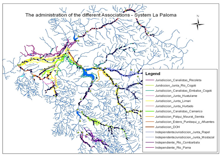
The organizations in the basin with major tradition are the ones belonging to the Paloma system (nine organizations), as well the state agencies (DOH, DGA). Indeed, the DOH (Direccion de Obras Hidraulicas) has been responsible for the largest reservoir, La Paloma during the last almost 40 years, as well as for the “canal Matriz” (main distribution canal). In 2008 a first memorandum of understanding (La Paloma, 2008) was signed between the state agencies, DOH and CNR and the private farmer organizations to be agreed upon to prepare the final transfer of the reservoir from state administration to the private organizations. This has been finalized around September 2012; the private organization had/have to find a form to manage the system. Now the macro-organization is called CASEP (Comunidades de aguas de embalse La Paloma), before that they were called: El cuerpo colegiado. All organizations of the System finally signed although not all are participating actively. Due to personal conversation of some of the stakeholders, until now there is no definition of the legal entity, or let’s say which legal status should the macro organization get etc. Unfortunately even though the transfer went with a lot of details the very important detail of how to organize it hasn’t been defined so far.
The Paloma System, a set of three reservoirs (La Paloma, Recoleta, and Cogotí) totalizing ca. 1,000 Mm3, consists basically of two different subsystems, the natural and the artificial system. In a simplified way, the “Juntas de Vigilancias” (i.e. river surveillance boards) are organizations dealing with the natural riverbed (four organisations), while the “Asociaciones de Canalistas” and “Comunidades de Aguas” refer on artificial aqueducts (five organisations). The latter are also responsible for irrigation in land areas above the channels.
Out of compiled GIS data (CEAZA, GORE, Rodhos, 2006, Alfaro, 2001, and field data from the organisations) the following map with the different administration areas could be generated. Herewith it can be distinguished which one are parts of the “La Paloma System”.
References and further reading:
Álvarez, P., Kretschmer, N., Oyarzún, R. (2006) Water Management for Irrigation in Chile: Causes and Consequences, paper presented at the international water fair “Wasser Berlin 2006”.
CIREN (1994) Estudio Agrológico de los valles de Choapa, Illapel y Limarí, Centro de Información de Recursos Naturales.
CIREN (2012) Describciones de suelos, Materiales y Simbolos, Publicación CIREN no. 129, Propiedad Intelectual N°151.231, ISBN956-7153-65-5, Esta edición complementa la cartografía digital de suelos, actualizada sobre 215 ortoimágenes satelitales año 2010-2011 en escala de salida 1:10.000 (the map in the annex shows the area of study).
DGA (2004) Diagnóstico y Clasificación de los Cursos y Cuerpos de Agua según Objetivos de Calidad, Cuenca del Río Limarí, elaborado por CADE‐IDEPE Consultores en Ingeniería.
FAO (2002) Digital Soil Map of the World and derived soil properties, Land and Water Digital Media Series #1 rev 1. FAO, Rome.
INE (2007) Censo Agropecuario (2007), www.inecoquimbo.cl, accessed: 18.04.2012.
INIA (2009) Tierra adentro, frutales y viñas, Valle del Limarí, un aporte a la fruticultura chilena, http://www.inia.cl/link.cgi/, accessed: 12.03.2012.
Oyarzún, R., Arumí, J. L., Álvarez, P., Rivera, D. (2008) Water use in the Chilean agriculture: current situation and areas for research development, in: Sorensen ML (ed) Agricultural water management trends, Nova Publishers, New York, 213-236.
Oyarzún, R. (2010) Estudio de caso: Cuenca del Limarí, Región de Coquimbo, Chile, Compilación Resumida de Antecedentes, Centro de Estudios Avanzados en Zonas Aridas-Universidad de la Serena (CEAZA-ULS).
Parga, F., León, A., Vargas, X., Fuster, Y. (2006) El índice de pobreza hídrica aplicado a la cuenca del río Limarí en Chile semiárido, Eval. Usos del Agua en Tierras Secas de Iberoamérica, 12: 93-109.
Strauch, G., Oyarzún, R., Reinstorf, F., Oyarzún, J., Schirmer, M., Knöller, K. (2009) Interaction of water components in the semi-arid Huasco and Limarí river basins, North Central Chile, Advances in Geosciences, 22, 51–57.